Who What Where WhenREMOVE |
REFINE
Browse All : Images of Mississippi River
1-28 of 28
Author
Jefferys, Thomas
Full Title
Course Of The River Mississipi, from the Balise to Fort Chartres; Taken on an Expedition to the Illinois, in the latter end of the Year 1765. By Lieut. Ross of the 34th Regiment: Improved from the Surveys of that River made by the French. London Printed for Robt. Sayer ... 1 June 1775.
Publisher
Sayer and Bennett
Author
Nicollet, J. N. (Joseph Nicolas), 1786-1843
Full Title
(Title Page to) Report Intended To Illustrate A Map Of The Hydrographical Basin of the Upper Mississippi River, Made by I.N. Nicollet ... February 16, 1841. Washington: Blair and Rives, Printers. 1843. [Senate.] 26th Congress, 2d Session. [237].
Publisher
Blair and Rives
Author
Nicollet, J. N. (Joseph Nicolas), 1786-1843
Full Title
Hydrographical Basin of the Upper Mississippi River From Astronomical and Barometrical Observations Surveys and Information by J.N. Nicollet ... assisted ... by Lieut. J.C. Fremont ... Reduced and compiled under the direction of Col. J.J. Abert in the Bureau of the Corps of Topl. Engrs. by Lieut. W.H. Emory ... 1843 ... W.J. Stone Sc.
Publisher
Blair and Rives
Author
[Colton, J. H., Norman, B.M., Persac, A.]
Full Title
Norman's Chart Of The Lower Mississippi River By A. Persac. Published by B.M. Norman, New Orleans, La. 1858. Entered ... 1858 by B.M. Norman ... Louisiana. Engraved, Printed & Mounted By J.H. Colton & Co. New York. (At top) From Natchez to New Orleans.
Publisher
B.M. Norman
Author
U.S. War Department, Topographical Engineers
Full Title
Map Of The United States And Their Territories Between The Mississippi and the Pacific Ocean And Of Part of Mexico. Compiled in the Bureau of the Corps of Topogl. Engs. under a Resolution of the U.S. Senate. From the best authorities which could be obtained. 1850. Engraved by Sherman and Smith, New-York.
Publisher
Sherman and Smith
Author
[Vorzet, Ed.Dumas, Le Comte de Paris]
Full Title
Planche XX. Cours du Mississippi de Vicksburg a Baton-Rouge. Dessine par Ed. Dumas Vorzet. Michel Levy, freres. Editeurs. Imp. Becquet, Paris. Grave par L. Wuhrer, R. Gay-Lussac 52.
Publisher
Michel Levy Freres
Author
[Vorzet, Ed.Dumas, Le Comte de Paris]
Full Title
Planche XXX. Cours Inferieur du Mississippi. Dessine par Ed. Dumas Vorzet. Michel Levy, freres. Editeurs. Imp. Becquet, Paris. Grave par L. Wuhrer, R. Gay-Lussac 52.
Publisher
Michel Levy Freres
Author
Coloney, Fairchild & Co.
Full Title
Coloney & Fairchild's Patent Ribbon Maps ... Ribbon Map Of The Father Of Waters. Geographical and Scenic Maps upon this plan of all the rivers, rail road routes, stage and coast lines in the country are in preparation.
Publisher
Gast, Moeller & Co. Lith.
Author
[Raynolds,W.F., Maynadier, H.E., Gillespie,G.]
Full Title
(Covers to) Western Sheet. Map Of The Yellowstone And Missouri Rivers. From Capt. Raynolds exploration 1859-60, with additions by Major Gillespie. Published by authority of the Hon. the Secretary Of War...
Publisher
U.S.
Author
[Raynolds,W.F., Maynadier, H.E., Gillespie,G.]
Full Title
Western Sheet. Map Of The Yellowstone And Missouri Rivers. From Capt. Raynolds exploration 1859-60, with additions by Major Gillespie. Published by authority of the Hon. the Secretary Of War...
Publisher
U.S.
Author
Lloyd, J.T.
Full Title
Lloyd's Map of the Lower Mississippi River From St. Louis To The Gulf Of Mexico. Compiled From Government Surveys In The Topographical Bureau, Washington, D.C. Revised and corrected to the present time by Captains Bart and William Bowen ... Price, in sheets, Colored, 50 Cents per copy. Pocket Edition, $1.00. Mounted Edition on Rollers and Varnished, $1.00 ... J.T. Lloyd, Publisher. 164 Broadway, New York 1863. Entered ... 1862, by J.T. Lloyd ... New York. (on verso) Lloyd's New Map of the United States, The Canadas And New Brunswick ... 1864 ... Entered ... 1863, by J.T Lloyd ... New York. (untitled inset map of Southern Florida).
Publisher
J.T. Lloyd
Author
Lloyd, J.T.
Full Title
Lloyd's New Map of the United States, The Canadas And New Brunswick ... 1864 ... Entered ... 1863, by J.T Lloyd ... New York. (untitled inset map of Southern Florida). (on verso) Lloyd's Map of the Lower Mississippi River From St. Louis To The Gulf Of Mexico. Compiled From Government Surveys In The Topographical Bureau, Washington, D.C. Revised and corrected to the present time by Captains Bart and William Bowen ... Price, in sheets, Colored, 50 Cents per copy. Pocket Edition, $1.00. Mounted Edition on Rollers and Varnished, $1.00 ... J.T. Lloyd, Publisher. 164 Broadway, New York 1863. Entered ... 1862, by J.T. Lloyd ... New York.
Publisher
J.T. Lloyd
Author
[Poirson, J.B., Herbin de Halle, Etienne de.]
Full Title
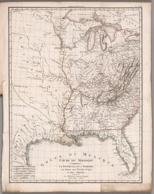
Cours du Mississippi comprenant la Louisiane, les 2 Florides, une partie des Etats-Unis et pays adjacents. Par J. B. Poirson, ingenieur geographe ; Nivose An XI (1803), grave par Tardieu l'aine rue de Sorbonne, no. 385. (on upper right margin) No.XVIII. (to accompany) Statistique Generale et Particuliere De La France et De Ses Colonies, avec une Nouvelle Description ... 1804.
Publisher
F. Buisson
Author
Magnus, Charles
Full Title
Panorama Of The Mississippi Valley And Its Fortifications. Published by C. Magnus, 12 Frankfort Street, New York. Eng. by F.W. Boell.
Publisher
Charles Magnus
Author
[Collot, George Henri Victor, Tardieu, P.F.]
Full Title
Map of the Course of The Mississippi from the Missouri and the Country of The Illinois to the mouth of this River. PL. 23.
Publisher
Arthus Bertrand
Author
[Collot, George Henri Victor, Tardieu, P.F.]
Full Title
Plan of Cape Girardo. Grave par Tardieu l'aine. PL. 26.
Publisher
Arthus Bertrand
Author
[Collot, George Henri Victor, Tardieu, P.F.]
Full Title
Plan of St. Lewis With the Project of an intrenched Camp French. Grave par Tardieu l'aine. PL. 27.
Publisher
Arthus Bertrand
Author
[Collot, George Henri Victor, Tardieu, P.F.]
Full Title
Map of the Country Of The Illinois. PL. 28.
Publisher
Arthus Bertrand
Author
[Collot, George Henri Victor, Tardieu, P.F.]
Full Title
Plan of the Fort of New Madrid or Anse A La Graisse. Grave par Tardieu l'aine. PL. 30.
Publisher
Arthus Bertrand
Author
[Collot, George Henri Victor, Tardieu, P.F.]
Full Title
Plan Of Fort Des Ecores at Margot. PL. 31.
Publisher
Arthus Bertrand
Author
[Collot, George Henri Victor, Tardieu, P.F.]
Full Title
Plan Of Nogales. Grave par Tardieu l'aine. PL. 32.
Publisher
Arthus Bertrand
Author
[Collot, George Henri Victor, Tardieu, P.F.]
Full Title
Town and Fort of Natchez. Grave par Tardieu l'aine. PL. 34.
Publisher
Arthus Bertrand
Author
[Collot, George Henri Victor, Tardieu, P.F.]
Full Title
Plan Of Fort Baton Rouge. Grave par Tardieu l'aine. PL. 35.
Publisher
Arthus Bertrand
Author
[Collot, George Henri Victor, Tardieu, P.F.]
Full Title
Sketch of new Orleans taken from fort St. Charles. Sketch of Plaquemine Fort. Grave par Tardieu l'aine. PL. 36.
Publisher
Arthus Bertrand
Author
[Bowen, Bart, Bowen, William, Lloyd, J. T.]
Full Title
Lloyd's map of the Lower Mississippi River from St. Louis to the Gulf of Mexico. Compiled from government surveys in the Topographical Bureau, Washington, D.C. Revised and corrected to the present time by Captains Bart and William Bowen, pilots of twenty years' experience on that River. Exhibiting the sugar and cotton plantations, cities, towns, landings, sand bars, islands, bluffs, bayous, cut-offs, the steamboat channel, mileage, fortifications, railroads. &c. along the River. J.T. Lloyd, Publisher. 164 Broadway, New York 1862. Entered ... 1862, by J.T. Lloyd ... New York.
Publisher
J.T. Lloyd
Author
Ross, Lieut.
Full Title
Course of the River Mississipi, from the Balise to Fort Chartres; taken on an expedition to the Illinois, in the latter end of the year 1765. By Lieut. (John) Ross of the 34th Regiment: Improved from the surveys of the river made by the French. London, printed for Robt. Sayer, no. 53 in Fleet Street, published as the Act directs, 1 June 1775.
Publisher
Robert Sayer
Author
Pike, Zebulon Montgomery
Full Title
Map of the Mississippi River from its Source to the Mouth of the Missouri: Laid down from the notes of Lieut. Z.M. Pike by Anthony Nau. Reduced and corrected by the Astronomical Observations of Mr. Thompson at its source; and of Captn. M. Lewis, where it receives the waters of the Missouri. By Nichs. King. Engraved by Francis Shallus, Philadelphia.
Publisher
C. & A. Conrad
Author
Coloney, Fairchild & Co.
Full Title
Coloney & Fairchild's Patent Ribbon Maps ... Ribbon Map Of The Father Of Waters. Geographical and Scenic Maps upon this plan of all the rivers, rail road routes, stage and coast lines in the country are in preparation.
Publisher
Gast, Moeller & Co. Lith.
1-28 of 28
|