Browse All

1776 Course Of The River Mississipi, from the … National Atlas Course Of The River Mississipi, from the … |

1843 Title Page: Report intended to illustrat … Exploration Book (Title Page to) Report Intended To Illus … |

1843 Hydrographical Basin of the Upper Missis … Exploration Book Hydrographical Basin of the Upper Missis … |

1858 Chart Of The Lower Mississippi River. Pocket Map Norman's Chart Of The Lower Mississippi … |

1850 Map of the United States. Separate Map Map Of The United States And Their Terri … |

1875 Planche XX. Cours du Mississippi de Vick … Military Atlas Planche XX. Cours du Mississippi de Vick … |

1875 Planche XXX. Cours Inferieur du Mississi … Military Atlas Planche XXX. Cours Inferieur du Mississi … |

1866 Ribbon Map Of The Father Of Waters. Separate Map Coloney & Fairchild's Patent Ribbon Maps … |

1877 Covers: Map Of The Yellowstone And Misso … Pocket Map (Covers to) Western Sheet. Map Of The Ye … |

1877 Map Of The Yellowstone And Missouri Rive … Pocket Map Western Sheet. Map Of The Yellowstone An … |

1863 Map of the Lower Mississippi River From … Separate Map Lloyd's Map of the Lower Mississippi Riv … |

1864 New Map of the United States The Canadas … Separate Map Lloyd's New Map of the United States, Th … |
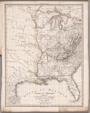
1803 Cours du Mississippi comprenant la Louis … Geography Book Cours du Mississippi comprenant la Louis … |

1863 Panorama Of The Mississippi Valley And I … Separate Map Panorama Of The Mississippi Valley And I … |

1796 Map of the Course of The Mississippi fro … National Atlas Map of the Course of The Mississippi fro … |

1796 Plan of Cape Girardo. National Atlas Plan of Cape Girardo. Grave par Tardieu … |

1796 Plan of St. Lewis With the Project of an … National Atlas Plan of St. Lewis With the Project of an … |

1796 Map of the Country Of The Illinois. National Atlas Map of the Country Of The Illinois. PL. … |

1796 Plan of the Fort of New Madrid or Anse A … National Atlas Plan of the Fort of New Madrid or Anse A … |

1796 Plan Of Fort Des Ecores at Margot. National Atlas Plan Of Fort Des Ecores at Margot. PL. 3 … |

1796 Plan Of Nogales. National Atlas Plan Of Nogales. Grave par Tardieu l'ain … |

1796 Town and Fort of Natchez. National Atlas Town and Fort of Natchez. Grave par Tard … |

1796 Plan Of Fort Baton Rouge. National Atlas Plan Of Fort Baton Rouge. Grave par Tard … |

1796 Sketch of new Orleans taken from fort St … National Atlas Sketch of new Orleans taken from fort St … |

1862 Lloyd's map of the Lower Mississippi Riv … Separate Map Lloyd's map of the Lower Mississippi Riv … |

1775 Course Of The River Mississipi, from the … World Atlas Course of the River Mississipi, from the … |

1810 Map of the Mississippi River from its So … Exploration Book Map of the Mississippi River from its So … |
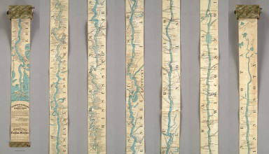
1866 Ribbon Map Of The Father Of Waters. Separate Map Coloney & Fairchild's Patent Ribbon Maps … |