Who What Where When |
REFINE
Browse All : Images of Nebraska from 1859
1-12 of 12
Author
[Colton, J. H., Warren, Gouverneur Kemble, 1830-1882, Redpath, James, Hinton, Richard J]
Full Title
(Covers to) Hand Book To Kansas Territory And The Rocky Mountains' Gold Region; Accompanied By Reliable Maps and a Preliminary Treatise on the Pre-emption Laws of the United States. By James Redpath and Richard J. Hinton, of Kansas. New York: J.H. Colton, Publisher, 172 William Street. 1859. (on verso) Entered ... in the year 1859, (Published) by J.H. Colton ... New York.
Publisher
J. H. Colton.
Author
[Colton, J. H., Warren, Gouverneur Kemble, 1830-1882, Redpath, James, Hinton, Richard J]
Full Title
Catalog) Hand Book To Kansas Territory And The Rocky Mountains' Gold Region; Accompanied By Reliable Maps and a Preliminary Treatise on the Pre-emption Laws of the United States. By James Redpath and Richard J. Hinton, of Kansas. New York: J.H. Colton, Publisher, 172 William Street. 1859. (on verso) Entered ... in the year 1859, (Published) by J.H. Colton ... New York.
Publisher
J. H. Colton.
Author
[Colton, J. H., Warren, Gouverneur Kemble, 1830-1882, Redpath, James, Hinton, Richard J]
Full Title
(Title Page to) Hand Book To Kansas Territory And The Rocky Mountains' Gold Region; Accompanied By Reliable Maps and a Preliminary Treatise on the Pre-emption Laws of the United States. By James Redpath and Richard J. Hinton, of Kansas. New York: J.H. Colton, Publisher, 172 William Street. 1859. (on verso) Entered ... in the year 1859, (Published) by J.H. Colton ... New York.
Publisher
J. H. Colton.
Author
[Colton, J. H., Warren, Gouverneur Kemble, 1830-1882, Redpath, James, Hinton, Richard J]
Full Title
Kansas and Nebraska. 1859. (inset map) Nebraska and Kansas, Showing Pikes Peak And The Gold Region. 1859. (Published) by J.H. Colton & Co., 172 William St., New York.
Publisher
J. H. Colton.
Author
[Colton, J. H., Warren, Gouverneur Kemble, 1830-1882, Redpath, James, Hinton, Richard J]
Full Title
Military Map of Parts of Kansas, Nebraska and Dakota. By Lieut. G.K. Warren Top. Engrs. from the Explorations made by him in 1855, 56 & 57. (Published) by J.H. Colton & Co., 172 William St., New York.
Publisher
J. H. Colton.
Author
Warren, Gouverneur Kemble, 1830-1882
Full Title
Military Map of Nebraska and Dakota...From the Explorations made by him in 1855, 6...and in 1857...
Publisher
U.S.
Author
Campbell, Albert
Full Title
Map of the Fort Ridgely & South Pass Road. To accompany the report of William H. Nobles, Superintendent, by Samuel A. Medary, Engr. 1858. T.S. Wagner's Lith., Philada. Drawn by John R. Key. (Sen. Ex. Doc. No. 36. Ho. Ex. Doc. No. 108 - 2nd Sess. 35 Cong.)
Publisher
T.S. Wagner's Lith.
Author
Mitchell, Samuel Augustus
Full Title
A New Map of Nebraska, Kansas, New Mexico, and Indian Territories. Published By Charles Desilver, Philadelphia. Entered according to Act of Congress in the year 1856 by Charles Desilver in the Clerk's office if the District Court of the Eastern District of Pennsylvania. 38.
Publisher
Charles Desilver.
Author
Mitchell, Samuel Augustus
Full Title
A New Map of Kansas by W.H. Holmes. Published by C. Desilver. No. 714 Chesnut St., Philadelphia. Herline & Hensel, Philada. Entered according to Act of Congress in the year 1859 by C. Desilver in the Clerk's office if the District Court of the Eastern District of Pennsylvania.
Publisher
Charles Desilver.
Author
Mitchell, Samuel Augustus
Full Title
A New Map of Nebraska, Kansas, New Mexico, and Indian Territories. Published By Charles Desilver, Philadelphia. Entered according to Act of Congress in the year 1859 by Charles Desilver in the Clerk's office if the District Court of the Eastern District of Pennsylvania. 38.
Publisher
Charles Desilver.
Author
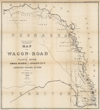
Campbell, Albert
Full Title
Map of the Wagon-Road from Platte River via Omaha Reserve and Dakota City to Running Water River. Geo. L. Sites, Supt. 1858. T.S. Wagner's Lith. Philada. Department of the Interior, Pacific Wagon Roads. (Sen. Ex. Doc. No. 36. Ho. Ex. Doc. No. 108 - 2nd Sess. 35 Cong.)
Publisher
T.S. Wagner's Lith.
1-12 of 12
|