Browse All

1868 Covers: California And Nevada Pocket Map (Covers to) Bancroft's Map Of California … |

1868 California And Nevada Pocket Map Bancroft's Map Of California And Nevada. … |

1868 Covers: White Pine District Lander Co. N … Pocket Map (Covers to) Map Of White Pine District L … |

1868 White Pine District Lander Co. Nev. Pocket Map Map Of White Pine District Lander Co. Ne … |

1883 Covers: California And Nevada Pocket Map (Covers to) Colton's California And Neva … |

1883 California And Nevada Pocket Map Colton's California And Nevada Edition P … |

1884 Covers: California and Nevada Pocket Map (Covers to) Colton's California and Neva … |

1884 California and Nevada Pocket Map Colton's California and Nevada. Publishe … |

1868 Covers: California And Nevada Pocket Map (Covers to) A New Map Of The States Of C … |

1868 California And Nevada Pocket Map A New Map Of The States Of California An … |

1934 Index: Nevada, Railway Distance Maps Guide Book (Index to) Leahy's Hotel Guide and Railw … |

1934 Railway Distance Map of the State of Nev … Guide Book Leahy's Hotel Guide and Railway Distance … |

1875 Covers: Map of the States Of California … Pocket Map (Covers to) Map of the States Of Califor … |

1875 Map of the States Of California And Neva … Pocket Map Map of the States Of California And Neva … |

1872 California and Nevada. State Atlas Atlas of the United States. California a … |

1997 California -- Physical (Raised Relief) Wall Map California, Nevada. |

1906 California, Nevada, Oregon (South). Neva … World Atlas California (North), Nevada, Oregon (Sout … |

1871 Bancroft's Map Of California, Nevada, Ut … Separate Map Bancroft's Map Of California, Nevada, Ut … |

1878 (Map 14 - California, Arizona, Nevada). Case Map (Map 14 - California, Arizona, Nevada). |

1878 (Map 15 - California, Nevada, Utah, Idah … Case Map (Map 15 - California, Nevada, Utah, Idah … |

1880 Nevada Mining Atlas Nevada. (to accompany) Pocket Mining Atl … |

1880 Comstock District, Nevada. No.1 Mining Atlas Comstock District, Nevada. No. 1. (to ac … |

1880 Comstock District, Nevada. No.2 Mining Atlas Comstock District, Nevada. No. 2. (to ac … |

1880 Eureka Mining District, Nevada Mining Atlas Eureka Mining District, Nevada. (to acco … |

1880 Eureka Mining District, Nevada Mining Atlas Eureka Mining District, Nevada. (to acco … |

1880 Map of Treasure Hill, White Pine County, … Mining Atlas Map of Treasure Hill, White Pine County, … |

1880 Tuscarora Mining District, Elco County, … Mining Atlas Tuscarora Mining District, Elco County, … |

1987 Nevada -- Physical Wall Map Nevada. |

1865 County map of Utah and Nevada World Atlas County map of Utah and Nevada. Drawn & E … |

1941 State of Nevada ; compiled from the offi … Separate Map State of Nevada ; compiled from the offi … |

1907 Map Of California, Nevada And Southern O … Wall Map Weber's Township And County Map Of Calif … |

1874 County map of Utah and Nevada World Atlas County map of Utah and Nevada. Drawn and … |

1885 Plate XXXVIII: An island of Tufa in Pyra … Geology Book An island of Tufa in Pyramid Lake, Nevad … |

1885 Plate XXXIX: Tufa towers on the shore of … Geology Book Tufa towers on the shore of Pyramid Lake … |

1885 Plate XL: Tufa castle, west of Pyramid L … Geology Book Tufa castle, west of Pyramid Lake, Nevad … |

1885 Plate XLI: Tufa domes in Pyramid Lake, N … Geology Book Tufa domes in Pyramid Lake, Nevada. (to … |

1885 Plate XLII: Tufa tower on the shore of W … Geology Book Tufa tower on the shore of Winnemucca La … |

1885 Plate XLIII: Tufa domes in Mono Lake, Ca … Geology Book Tufa domes in Mono Lake, California. (to … |

1885 Plate XLIV: Post - quaternary fault line … Geology Book Post - quaternary fault lines. Julius Bi … |

1885 Plate XLV: Post - quaternary fault on th … Geology Book Post - quaternary fault on the south sho … |
1885 Plate XLVI: Lake Lahontan : a quaternary … Geology Book Lake Lahontan : a quaternary lake of nor … |

1877 County map of Utah and Nevada World Atlas County map of Utah and Nevada. Drawn and … |

1868 County map of Utah and Nevada World Atlas County map of Utah and Nevada. Drawn and … |

1885 Title Page: Monographs of the United Sta … Geology Book (Title Page to) Department of Interior : … |

1885 Title Page: Monographs of the United Sta … Geology Book (Title Page to) Geological history of La … |

1885 Plate I: Quaternary lakes of the Great B … Geology Book Quaternary lakes of the Great Basin. Jul … |

1885 Plate II: Routes traveled and areas surv … Geology Book Routes traveled and areas surveyed. Juli … |

1885 Plate III: Pre-Quternary fault lines Geology Book Pre-Quternary fault lines. Julius Bien & … |

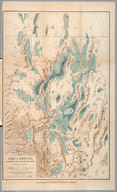
1885 Plate IV: Map of Lake Lahontan Geology Book Map of Lake Lahontan : showing water are … |

1885 Plate V: Depth of Lake Lahontan at highe … Geology Book Depth of Lake Lahontan at highest water … |