Browse All

1832 N.Y., Vt., Maine, N.H., Mass., Conn., R. … World Atlas North America sheet VI. New-York, Vermon … |

1874 N.H., Vt., Mass., R.I., Conn. National Atlas Asher & Adams' New Hampshire, Vermont, M … |

1925 Covers: New England Pocket Map (Covers to) Rand McNally Junior Road Map … |

1925 New England Pocket Map Rand McNally Junior Road Map New England … |

1847 Covers: Maine, New Hampshire, Vermont, M … Pocket Map (Covers to) Map Of The States Of Maine, … |

1847 Map of the States of Maine, New Hampshir … Pocket Map Map Of The States Of Maine, New Hampshir … |

1847 Map Of New England Broadside Map Of New England. Published By Ensign … |

1872 Atlas of the United States, New England, … [National Atlas, State Atlas] Atlas of the United States, New England, … |

1877 New England with adjacent portions of Ne … State Atlas Map of New England with adjacent portion … |

1910 Covers: New England Pocket Map (Covers to) Map Of New England With popu … |

1910 Text Page: New England Census of 1910 Pocket Map (Text Page to) Map Of New England With p … |

1910 New England Pocket Map Map Of New England With population and L … |

1833 States of Maine, New Hampshire, Vermont, … World Atlas Map of the States of Maine, New Hampshir … |

1816 Canada. World Atlas Canada, &c. 8. H.S. Tanner, sc. (1816) |

1815 Composite: Lower Canada National Atlas (Composite of) To His Royal Highness Geo … |

1815 Composite: Lower Canada western. National Atlas (Composite of western sheets). (To His R … |

1815 Composite: Lower Canada eastern National Atlas (Composite of eastern sheets) To His Roy … |

1822 Canada &c. World Atlas Canada &c. S. Lewis, del. H.S. Tanner, S … |

1827 Cover: New England States. Case Map (Covers to) A Map of the New England Sta … |

1827 A Map of the New England States. Case Map A Map of the New England States, Maine, … |

1872 New England and New York. State Atlas Atlas of the United States. New England … |

1677 A map of New England Geography Book A map of New England, being the first th … |

1828 The north eastern coast, North America, … Chart Atlas (The north eastern coast of North Americ … |

1828 Composite: NE coast North America, N.Y. … Chart Atlas (Composite of) The north eastern coast o … |

1830 New England, N.Y. 1697. National Atlas New England and New York in 1697. From t … |

1819 United States. School Atlas United States. (with) New England States … |

1832 New England, Middle States. School Atlas New England States. Middle States. H. Mo … |

1830 New England. School Atlas New England States. J.H. Young Sc. (Phil … |

1830 New England States. School Atlas New England States. Entered ... 12th day … |

1836 New England. School Atlas New England. Entered ... 1836, by Eleaze … |

1873 New England and New York. State Atlas Atlas of the United States. New England … |

1829 Eastern States. School Atlas Eastern States. Entered according to Act … |

1831 Connecticut, New-England. World Atlas Connecticut. New-England. G. Boynton Sc. … |

1847 New England. School Atlas Map of the New England or Eastern States … |

1755 Nova Scotia, Cape Britain. Geography Book A new map of Nova Scotia and Cape Britai … |

1758 New England World Atlas New England. (to accompany) Atlas Minimu … |
1888 Intl. Steamship Co.'s routes. Timetable Map Map showing the International Steamship … |

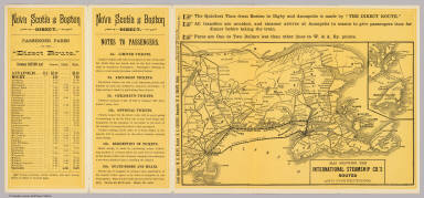
1888 Cover: Nova Scotia excursion route. Timetable Map (Covers to) Nova Scotia excursion route. … |

1888 Text Page: Nova Scotia excursion route. Timetable Map (Text Page to) Nova Scotia excursion rou … |

1871 Railway map New England States. Timetable Map Railway map of the New England States, e … |

1871 Text Page: Pathfinder railway guide supp … Timetable Map (Text Page to) Pathfinder railway guide … |

1871 Railway map New England States. Timetable Map Railway map of the New England States, e … |

1871 Text Page: Pathfinder railway guide supp … Timetable Map (Text Page to) Pathfinder railway guide … |

1828 New England National Atlas New England. (to accompany) A New Pocket … |

1907 Trolley Wayfinder : birds eye view of tr … Pocket Map Trolley Wayfinder : birds eye view of tr … |

1939 Pictorial Map of the New England States … Separate Map A Pictorial Map of the New England State … |

1871 New England. State Atlas Map of New England with adjacent portion … |

1878 New England. National Atlas Cram's Rail Road & County Map of New Eng … |

1747 N.J., Pa., N.Y. & New England. Geography Book A new and accurate map of New Jersey, Pe … |

1832 New-York State, surrounding country. State Atlas Map of the State of New-York and the sur … |