Browse All

1867 Covers: New Haven, Middletown And Boston … Pocket Map (Covers to) Map showing the Line of The … |

1867 New Haven, Middletown And Boston Railroa … Pocket Map Map showing the Line of The New Haven, M … |
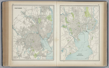
1901 Providence. New Haven. World Atlas Providence. New Haven. |

1855 Map of Connecticut World Atlas Map of Connecticut. Published by Thomas, … |

1893 Smith, Bourn & Co. Forsyth Dyeing Co. State Atlas Smith, Bourn & Co., harness and saddlery … |

1893 F.M. Brown & Co. State Atlas F.M. Brown & Company, importers and reta … |

1893 New Haven S. State Atlas South part of city of New Haven, town of … |

1893 New Haven N. State Atlas North part of city of New Haven, town of … |

1893 New Haven E. State Atlas East part of city of New Haven, Fairhave … |

1848 Connecticut. World Atlas Connecticut. Entered according to Act of … |

1846 New Haven Harbor. Chart Atlas New Haven Harbor. Founded upon a trigono … |

1859 Connecticut. World Atlas Map of Connecticut. Philadelphia, Publis … |

1893 Ward 15, New Haven. State Atlas Ward 15, town of New Haven. (with) Stony … |

1893 Peck Bros. & Co. State Atlas Manufactory and warerooms of Peck Bros. … |
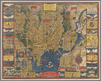
1928 New Haven. Separate Map New Haven. Published by the Edward P. Ju … |

1836 Connecticut. World Atlas Connecticut By H.S. Tanner. Engraved by … |

1859 Connecticut. World Atlas Map of Connecticut. Philadelphia, Publis … |

1845 Connecticut. World Atlas Connecticut By H.S. Tanner. Engraved by … |