Who What Where WhenREMOVE |
REFINE
Browse All : Images of New York and New Jersey from 1891
1-19 of 19
Author
[Bien, Joseph Rudolf, Vermeule, C. C. (Cornelius Clarkson), 1858-1950]
Full Title
Index map showing the area covered by this atlas, and boundaries and numbers of the various maps. Copyrighted by Julius Bien & Co., 1890. (1891)
Publisher
Julius Bien
Author
[Bien, Joseph Rudolf, Vermeule, C. C. (Cornelius Clarkson), 1858-1950]
Full Title
City and county of New York. Copyrighted by Julius Bien & Co., 1890. (1891)
Publisher
Julius Bien
Author
[Bien, Joseph Rudolf, Vermeule, C. C. (Cornelius Clarkson), 1858-1950]
Full Title
Brooklyn, New York Bay, Jersey City, Hoboken, Bayonne and Newark Bay. Copyrighted by Julius Bien & Co., 1890. (1891)
Publisher
Julius Bien
Author
[Bien, Joseph Rudolf, Vermeule, C. C. (Cornelius Clarkson), 1858-1950]
Full Title
Richmond County, Staten Island. Copyrighted by Julius Bien & Co., 1890. (1891)
Publisher
Julius Bien
Author
[Bien, Joseph Rudolf, Vermeule, C. C. (Cornelius Clarkson), 1858-1950]
Full Title
Westchester County, Yonkers to Dobbs Ferry, east to state line. Copyrighted by Julius Bien & Co., 1890. (1891)
Publisher
Julius Bien
Author
[Bien, Joseph Rudolf, Vermeule, C. C. (Cornelius Clarkson), 1858-1950]
Full Title
(Contents to) Atlas of the Metropolitan District and adjacent country comprising the counties of New York, Kings, Richmond, Westchester and part of Queens in the state of New York, the County of Hudson and parts of the counties of Bergen, Passaic, Essex and Union in the state of New Jersey ... From original surveys by J.R. Bien and C.C. Vermeule, the U.S. Coast and Geodetic Survey and the Geological Survey of New Jersey. Published by Julius Bien & Co. New York. 1891.
Publisher
Julius Bien
Author
[Bien, Joseph Rudolf, Vermeule, C. C. (Cornelius Clarkson), 1858-1950]
Full Title
(Covers to) Atlas of the Metropolitan District and adjacent country comprising the counties of New York, Kings, Richmond, Westchester and part of Queens in the state of New York, the County of Hudson and parts of the counties of Bergen, Passaic, Essex and Union in the state of New Jersey ... From original surveys by J.R. Bien and C.C. Vermeule, the U.S. Coast and Geodetic Survey and the Geological Survey of New Jersey. Published by Julius Bien & Co. New York. 1891.
Publisher
Julius Bien
Author
[Bien, Joseph Rudolf, Vermeule, C. C. (Cornelius Clarkson), 1858-1950]
Full Title
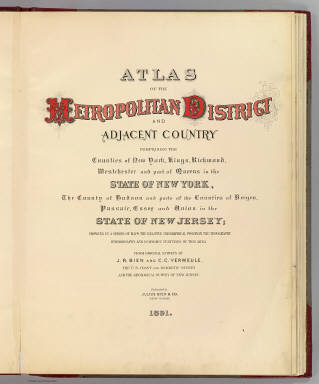
(Title Page to) Atlas of the Metropolitan District and adjacent country comprising the counties of New York, Kings, Richmond, Westchester and part of Queens in the state of New York, the County of Hudson and parts of the counties of Bergen, Passaic, Essex and Union in the state of New Jersey ... From original surveys by J.R. Bien and C.C. Vermeule, the U.S. Coast and Geodetic Survey and the Geological Survey of New Jersey. Published by Julius Bien & Co. New York. 1891.
Publisher
Julius Bien
Author
[Beers, F. W. (Frederick W.), Watson & Co. (New York, N.Y.)]
Full Title
Portion of Yonkers and 24th ward. Portion of Bergen County, N.J. Copyrighted, 1891, by Watson & Co.
Publisher
Watson & Co.
Author
[Beers, F. W. (Frederick W.), Watson & Co. (New York, N.Y.)]
Full Title
Portion of Bergen County, N.J. Portion of city of Yonkers and Westchester County. Copyrighted, 1891, by Watson & Co.
Publisher
Watson & Co.
Author
[Beers, F. W. (Frederick W.), Watson & Co. (New York, N.Y.)]
Full Title
Portion of Rockland County. Portion of Westchester County. Copyrighted, 1891, by Watson & Co.
Publisher
Watson & Co.
Author
Beers, F. W. (Frederick W.)
Full Title
(Covers to) Atlas of the Hudson River Valley from New York City to Troy, including a section of about 8 miles in width. Published by Watson & Co., 278 Pearl Street and 36 Vesey Street, New York. Compiled from official records and careful surveys, under the supervision of F.W. Beers, C.E., 1891. Copyright 1891, by Watson & Co.
Publisher
Watson & Co.
Author
Beers, F. W. (Frederick W.)
Full Title
(Title Page to) Atlas of the Hudson River Valley from New York City to Troy, including a section of about 8 miles in width. Published by Watson & Co., 278 Pearl Street and 36 Vesey Street, New York. Compiled from official records and careful surveys, under the supervision of F.W. Beers, C.E., 1891. Copyright 1891, by Watson & Co.
Publisher
Watson & Co.
Author
Beers, F. W. (Frederick W.)
Full Title
Index to maps in Hudson River Valley atlas. Copyrighted 1891, by Watson & Co.
Publisher
Watson & Co.
Author
[Beers, F. W. (Frederick W.), Watson, Gaylord]
Full Title
Map of New-York, Brooklyn, Jersey City &c. Published by Gaylord Watson, 278 Pearl Street, New York. 1891.
Publisher
Watson & Co.
Author
[Beers, F. W. (Frederick W.), Watson, Gaylord]
Full Title
Watson's new map of New-York and adjacent cities. Published by Gaylord Watson, 278 Pearl Street, New York. 1891.
Publisher
Watson & Co.
Author
[Beers, F. W. (Frederick W.), Watson & Co. (New York, N.Y.)]
Full Title
Portion of Bergen County, N.J. Copyrighted, 1891, by Watson & Co.
Publisher
Watson & Co.
Author
Rand McNally and Company
Full Title
(Covers to) Rand, McNally & Co.'s New Shippers' Railroad Map of the United States. Scale: 8 miles to one inch. Showing all railroads, each in a separate color, and all railroad stations in large, plain type. This is the New York section, only, of the above-named map. (Below the neatline) Rand, McNally & Co.'s New Shippers' Railroad Map of the United States, Copyright, 1888 by Rand, McNally & Co. Copyright, 1891 by Rand, McNally & Co.
Publisher
Rand McNally & Co.
Author
Rand McNally and Company
Full Title
Rand, McNally & Co.'s New Shippers' Railroad Map of the United States. Scale: 8 miles to one inch. Showing all railroads, each in a separate color, and all railroad stations in large, plain type. This is the New York section, only, of the above-named map. (Below the neatline) Rand, McNally & Co.'s New Shippers' Railroad Map of the United States, Copyright, 1888 by Rand, McNally & Co. Copyright, 1891 by Rand, McNally & Co.
Publisher
Rand McNally & Co.
1-19 of 19
|