Who What Where WhenREMOVEWHATShow More |
Author
Mitchell, Samuel Augustus
Full Title
Map Of North and South Carolina And Georgia, Constructed from the Latest Authorities. Published by S. Augustus Mitchell Philadelphia. 1831. J.H. Young Sc.
Publisher
S.A. Mitchell
Author
Burr, David H., 1803-1875
Full Title
Map of North And South Carolina Exhibiting the Post Offices, Post Roads, Canals, Rail Roads, &c. By David H. Burr. (Late Topographer to the Post Office.) Geographer to the House of Representatives of the U.S. John Arrowsmith. Entered ... July 10th, 1839, by David H. Burr ... District of Columbia.
Publisher
John Arrowsmith
Author
Colton, J. H.
Full Title
Colton's New Topographical Map Of The Eastern Portion Of The State Of North Carolina With Part Of Virginia & South Carolina From The Latest & Best Authorities. Published by J.H. Colton, No. 172 William St. N.Y. 1863. Entered ... 1860 by J.H. Colton ... New York. Printed by Lang & Cooper, 117 Fulton St. N.Y. (inset) Plan Of The Sea Coast From Virginia To Florida.
Publisher
J.H. Colton
Author
Bachmann, John
Full Title
(Composite of) Panorama of the Seat of War. Birds eye view of Florida and part of Georgia and Alabama .. North and South Carolina and part of Georgia .. Virginia, Maryland, Delaware and the District of Columbia. John Bachmann, Publisher, 115 & 117 Nassau St., New York. Entered ... 1861 by John Bachmann ... New York. Drawn from Nature and Lith. by John Bachmann.
Publisher
John Bachmann
Author
Jefferys, Thomas
Full Title
An Accurate Map Of North And South Carolina With Their Indian Frontiers, Shewing in a distinct manner all the Mountains, Rivers, Swamps, Marshes, Bays, Creeks, Harbours, Sandbanks and Soundings on the Coasts; with The Roads and Indian Paths; as well as The Boundary or Provincial Lines, The Several Townships and other divisions of the Land In Both The Provinces; the whole From Actual Surveys By Henry Mouzon And Others. London. Printed for Robt. Sayer and J. Bennett ... May 30th 1775. (Northern Section)
Publisher
Sayer and Bennett
Author
Jefferys, Thomas
Full Title
(Composite of) An Accurate Map Of North And South Carolina With Their Indian Frontiers, Shewing in a distinct manner all the Mountains, Rivers, Swamps, Marshes, Bays, Creeks, Harbours, Sandbanks and Soundings on the Coasts; with The Roads and Indian Paths; as well as The Boundary or Provincial Lines, The Several Townships and other divisions of the Land In Both The Provinces; the whole From Actual Surveys By Henry Mouzon And Others. London. Printed for Robt. Sayer and J. Bennett ... May 30th 1775.
Publisher
Sayer and Bennett
Author
Schonberg & Co.
Full Title
North Carolina. South Carolina and Georgia.
Publisher
Schonberg & Co.
Author
Schonberg & Co.
Full Title
Schonberg's Map of the Carolinas: North & South. Entered ... 1866 ... New York.
Publisher
Schonberg & Co.
Author
Mitchell, Samuel Augustus
Full Title
(Covers to) Map Of The States Of North Carolina South Carolina and Georgia. Philadelphia: Published by S. Augustus Mitchell. 1836. Sold By Mitchell & Hinman No. 6 North Fifth Street. Entered ... 1835, by S. Augustus Mitchell ... Pennsylvania. Engraved by J.H. Young. (inset) Vicinity Of Charleston.
Publisher
S. Augustus Mitchell
Author
Mitchell, Samuel Augustus
Full Title
Map Of The States Of North Carolina South Carolina and Georgia. Philadelphia: Published by S. Augustus Mitchell. 1836. Sold By Mitchell & Hinman No. 6 North Fifth Street. Entered ... 1835, by S. Augustus Mitchell ... Pennsylvania. Engraved by J.H. Young. (inset) Vicinity Of Charleston.
Publisher
S. Augustus Mitchell
Author
Cram, George Franklin
Full Title
New Railroad and County Map of North & South Carolina.
Publisher
George F. Cram
Author
Colton, G.W.
Full Title
Colton's North Carolina And south Carolina. (insets) Beaufort Harbor, Plan of Charleston Vicinity & Harbor. Published By G. W & C. B. Colton & Co., No. 182 William St. New York.
Publisher
G. W & C. B. Colton & Co.
Author
Society for the Diffusion of Useful Knowledge (Great Britain)
Full Title
North America sheet XI. Parts of North and South Carolina. Published under the superintendence of the Society for the Diffusion of Useful Knowledge. J. & C. Walker sculpt. Published June 1st. 1833 by Baldwin & Cradock, 47 Paternoster Row, London. Printed by J. & C. Walker. (London: Chapman & Hall, 1844)
Publisher
Chapman and Hall
Author
Asher & Adams
Full Title
Asher & Adams' North Carolina and South Carolina. Entered according to Act of Congress in the year 1874 by Asher & Adams ... at Washington. (New York, 1874)
Publisher
Asher and Adams
Author
Tanner, Henry S.
Full Title
(Covers to) Map Of North & South Carolina. By H.S. Tanner. 1840. Published by H.S. Tanner, Philadelphia. Engraved by H.S. Tanner & Assistants. (above the neat line) American Atlas.
Publisher
H.S. Tanner
Author
Tanner, Henry S.
Full Title
Map Of North & South Carolina. By H.S. Tanner. 1840. Published by H.S. Tanner, Philadelphia. Engraved by H.S. Tanner & Assistants. (above the neat line) American Atlas.
Publisher
H.S. Tanner
Author
Cram, George Franklin
Full Title
Western Part of North and South Carolina.
Publisher
George F. Cram
Author
Cram, George Franklin
Full Title
Eastern Part of North and South Carolina.
Publisher
George F. Cram
Author
Cram, George Franklin
Full Title
(Composite of) North and South Carolina.
Publisher
George F. Cram
Author
Cram, George Franklin
Full Title
North and South Carolina.
Publisher
George F. Cram
Author
Johnson, A.J.
Full Title
Johnson's North And South Carolina By Johnson and Ward. (inset) Plan of Charleston, Vicinity & Harbor. (inset diagram) Fort Sumter.
Publisher
Johnson and Ward
Author
[Bayer, Herbert, Container Corporation of America]
Full Title
North Carolina. South Carolina. U.S. States. (inset) (Vicinity of Charleston).
Publisher
Container Corporation of America
Author
Engineer Bureau War Dept
Full Title
Map Showing Route of Marches of the Army of Genl. W.T. Sherman From Atlanta, Ga. to Goldsboro, N.C. To accompany the report of operations From Savannah, Ga. to Goldsboro, N.C. Engineer Bureau. War Department. Prepared by Order of the Secretary of War For the Officers of the U.S. Army under the Command of Maj. Gen. W.T. Sherman.
Publisher
War Dept.
Author
[Howe, Samuel Gridley, Ruggles, Samuel P.]
Full Title
Map of North & South Carolina.
Publisher
New England Institution for the Education of the Blind
Author
Johnson, A.J.
Full Title
Johnson's North Carolina and South Carolina. (inset) Map of Charleston Harbor. Entered ... 1865.
Publisher
A.J. Johnson
Author
[Duane, James C., United States. War Department]
Full Title
Map showing the operations of the Army of the Potomac under command of Maj. Gen. George G. Meade, from March 29th to April 9th, 1865. J.C. Duane, Major of Engineers ... (with) Map of portions of Mississippi, Alabama and Georgia showing march of Cavalry Corps, Military Division of the Mississippi, from March 22d to April 20th 1865. (with) No. 3. Map showing routes of marches of the army of Gen. W.T. Sherman from Atlanta, Ga. to Goldsborough, N.C. ... (with) Plat showing the battle-ground at Rivers' Bridge, Big Salkehatchie River, S.C. (with) Chart accompanying project for effectually closing Cape Fear River and the port of Wilmington, N.C. to blockade runners. (with) Plans, sections and elevation of pile bridge, James River near Varina, Va., January 1865. W.R. King, 1st Lieut. U.S. Engrs. ... Julius Bien & Co., Lith., N.Y. (1891-1895)
Publisher
U.S. Government Printing Office
Author
United States. War Department
Full Title
Map of the environs of Petersburg, Va. from the Appomattox River to Ft. Howard, showing the positions of the intrenched lines occupied by the 9th Army Corps, A.P., during the siege. Plat showing the positions of the Army of the Tennessee under command of Maj. Gen. O.O. Howard during the battle of Bentonville, N.C., March 20th and 21st 1865. Map showing the march routes of the Army of the Tennessee under the command of Maj. Gen. O.O. Howard during the winter campaign in the Carolinas. Surveyed and compiled under the direction of Col. C.B. Reese ... Drawn and compiled by L. Helmle ... Surveys by W. Griswold and J. Weld ... Topographical map showing the positions of the 14th and 20th Corps commanded by Maj. Gen. H.W. Slocum, and Kilpatrick's Cavalry in an engagement near Bentonville, N.C., March 19th, 1865. R.M. McDowell, Capt. and Top. Engr, Army of Ga. Map of battle of Averysborough, N.C., fought March 16th, 1865. Map of the battle-field of Pea Ridge, Ark. showing the positions of the United States and Confederate forces on the 8th of March, 1862. ... Published ... 1876. Plan no. 8, siege operations at Spanish Fort, Mobile Bay, by the U.S. forces under Maj. Gen. E.R. Canby. Captured by the Army of West Mississippi, on the night of April 8 and 9, 1865, Major M.D. McAlester, Senior Engr., Major J.C. Palfrey, Asst. Engr., Capt. C.J. Allen, Asst. Engr., Capt. Patten ... Asst. Engr. Julius Bien & Co., Lith., N.Y. (1891-1895)
Publisher
U.S. Government Printing Office
Author
[Asmussen, Charles W., United States. War Department]
Full Title
Campaign maps exhibiting the line of march of the 20th Corps from Savannah, Ga. to Goldsborough, N.C., with the plans of the battle-fields of Averysborough and Bentonville, N.C., from surveys of Topographical Engineers 20th Corps. Position of troops by Lieut. Col. C.W. Asmussen ... Rough sketch of Taylor's store, Ala. and surrounding country. Julius Bien & Co., Lith., N.Y. (1891-1895)
Publisher
U.S. Government Printing Office
Author
United States. War Department
Full Title
Campaign maps accompanying report of Bvt. Maj. Gen. J.W. Geary, U.S. Army, for the campaign from Savannah, Ga. to Goldsborough, N.C. 2d Division, 20th Corps. Campaign maps to accompany report of Bvt. Maj. Gen. J.W. Geary, U.S. Army for the campaign from Goldsborough, S.C. to Washington, D.C. 2d Division, 20th Corps, by Capt. O.L.F. Browne, A.T. Engr., 2d Division, 20th Corps. Operations about Bottom's Bridge, Va., May 20-23, 1862. Julius Bien & Co., Lith., N.Y. (1891-1895)
Publisher
U.S. Government Printing Office
Author
[Campbell, Albert H., Confederates States of America. Army of Northern Virginia, Henderson, D. E.]
Full Title
Chief Engineer's Office, D.N.V. Maj. Gen. J.F. Gilmer, Chief Engineer. Map of Spotsylvania County. Made under direction of A.H. Campbell, Capt. Engrs. in chg. Topl. Dept. General map. The vicinity of Hanover Junction, Va. and its defenses. Made under the direction of Capt. A.H. Campbell ... by Lieut. D.E. Henderson, Provl. Engrs., C.S. Army. (with) D. Sketch showing route pursued in the advance to Goldsborough, N.C. in December 1862. (with) Sketch showing position of Boyd's Neck, Honey Hill and Devaux's Neck, S.C. in December 1864. (with) Sketch of Spanish Fort defenses made during the siege by Lieut. J.A. Chalaron. Julius Bien & Co., Lith., N.Y. (1891-1895)
Publisher
U.S. Government Printing Office
Author
Johnson, A.J.
Full Title
Johnson's North Carolina and South Carolina. Published by A. J. Johnson, New York. 51. 52. Entered according to the Act of Congress, in the year 1865, by A.J. Johnson in the Clerk's Office of the District Court of the United States for the Southern District of New York.
Publisher
A.J. Johnson.
Author
Asher & Adams
Full Title
Asher & Adams' North Carolina and South Carolina. Entered according to Act of Congress 1874 by Asher & Adams in the Office of the Librarian of Congress at Washington.
Publisher
Asher & Adams.
Author
Tanner, Henry S.
Full Title
Map of North & South Carolina. By H.S. Tanner. 1827. American Atlas. Published by H.S. Tanner, Philadelphia. Entered according to Act of Congress, 20th Day of August, 1823, by H.S. Tanner, of the State of Pennsylvania.
Publisher
Henry Tanner
Author
Cram, George Franklin
Full Title
Cram's Rail Road & Township Map of North and South Carolina. Published by Geo. F. Cram. Proprietor of the Western Map Depot. 66, Lake St. Chicago Ills. 1875.
Publisher
Cram Atlas Company
Author
Rand McNally and Company
Full Title
Rand McNally junior auto road map North Carolina, South Carolina. Copyright by Rand McNally & Co., Chicago, Ill. (1927)
Publisher
Rand McNally
Author
Greenleaf, Jeremiah
Full Title
North and South Carolina.
Publisher
J. Greenleaf.
Author
Marshall, John
Full Title
Carte des Provinces Meridionales des Etats-Unis. (1807)
Publisher
Dentu, Imprimeur-Libraire.
Author
Marshall, John
Full Title
Theatre des Operations les plus importantes de l'Armee du Sud, dans la Virginie, dans les deux Carolines, et dans la Georgie. (1807)
Publisher
Dentu, Imprimeur-Libraire.
Author
Marshall, John
Full Title
A Map of those parts of Virginia, North Carolina, South Carolina, & Georgia, which were the scenes of the most important Operations of the Southern Armies. Compiled by S. Lewis. Engraved for the Life of Washington. Plate VIII. Engraved by Francis Shallus. Published by C.P. Wayne. Philadelphia. (1807)
Publisher
C.P. Wayne
Author
Burr, David H., 1803-1875
Full Title
North and South Carolina. W.F.H. Jr. Entered ... 1834 by Illman & Pilbrow ... New York.
Publisher
D.S. Stone
Author
Finley, Anthony
Full Title
Map Of North and South Carolina And Georgia, Constructed from the Latest Authorities. 1825. Copyright secured. J.H. Young Sculp. Published by A. Finley Philada. 1824.
Publisher
Anthony Finley
Author
Bellin, Jacques Nicolas, 1703-1772
Full Title
La Caroline : dans l'Amérique Septentrionale Suivant les Cartes Angloises.
Publisher
J.N. Bellin
Author
Asher & Adams
Full Title
(Covers to) Asher & Adams' New Commercial And Topographical Rail-Road Map And Guide Of North Carolina And South Carolina. Comprising A New Map, Colored By Counties, On A Scale Of Twenty Miles To An Inch; Delineating Rivers, Landings, Railroads, Stations with Distances, Etc. ... New York: American Rail Road Map And Guide Publishing Company, 39 Beekman Street. Entered... in the year one thousand eight hundred and seventy-four, by Asher & Adams ... Washington. (with map) Asher & Adams' North Carolina And South Carolina. Entered ... 1874 by Asher & Adams ... Washington.
Publisher
American Rail Road Map And Guide Publishing Company
Author
Asher & Adams
Full Title
Asher & Adams' New Commercial And Topographical Rail-Road Map And Guide Of North Carolina And South Carolina. Comprising A New Map, Colored By Counties, On A Scale Of Twenty Miles To An Inch; Delineating Rivers, Landings, Railroads, Stations with Distances, Etc. ... New York: American Rail Road Map And Guide Publishing Company, 39 Beekman Street. Entered... in the year one thousand eight hundred and seventy-four, by Asher & Adams ... Washington. (with map) Asher & Adams' North Carolina And South Carolina. Entered ... 1874 by Asher & Adams ... Washington.
Publisher
American Rail Road Map And Guide Publishing Company
Author
Asher & Adams
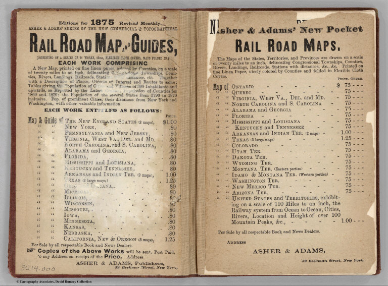
Full Title
(Text page to) Asher & Adams' New Commercial And Topographical Rail-Road Map And Guide Of North Carolina And South Carolina. Comprising A New Map, Colored By Counties, On A Scale Of Twenty Miles To An Inch; Delineating Rivers, Landings, Railroads, Stations with Distances, Etc. ... New York: American Rail Road Map And Guide Publishing Company, 39 Beekman Street. Entered... in the year one thousand eight hundred and seventy-four, by Asher & Adams ... Washington. (with map) Asher & Adams' North Carolina And South Carolina. Entered ... 1874 by Asher & Adams ... Washington.
Publisher
American Rail Road Map And Guide Publishing Company
Author
Asher & Adams
Full Title
(Text page to) Asher & Adams' New Commercial And Topographical Rail-Road Map And Guide Of North Carolina And South Carolina. Comprising A New Map, Colored By Counties, On A Scale Of Twenty Miles To An Inch; Delineating Rivers, Landings, Railroads, Stations with Distances, Etc. ... New York: American Rail Road Map And Guide Publishing Company, 39 Beekman Street. Entered... in the year one thousand eight hundred and seventy-four, by Asher & Adams ... Washington. (with map) Asher & Adams' North Carolina And South Carolina. Entered ... 1874 by Asher & Adams ... Washington.
Publisher
American Rail Road Map And Guide Publishing Company
Author
U.S. General Land Office
Full Title
(Map 2 - North Carolina, South Carolina, Georgia) (portion of title block shown reads:) 1876 Centennial Map.
Publisher
Julius Bien
Author
Mitchell, Samuel Augustus Jr.
Full Title
North and South Carolina. Entered ... 1874, by S. Augustus Mitchell ... Washington. (with inset maps) Plan of Charleston. Map of Charleston Harbor.
Publisher
S.A. Mitchell Jr.
|