Who What Where WhenREMOVE |
Author
Duflot de Mofras, Eugene
Full Title
(Covers to) Exploration Du Territoire De L'Oregon, Des Californies Et De La Mer Vermeille, Executee Pendant Les Annees 1840, 1841 Et 1842, Par M. Duflot De Mofras, Attache A La Legation De France A Mexico. Ouvrage Publie Par Ordre Du Roi, Sous Les Auspices De M. Le Marechal Soult, Duc De Dalmatie, President du Conseil, Et De M. Le Ministre Des Affaires Etrangeres. Tome Premier. Paris, Arthus Bertrand, Editeur, Libraire De La Societe De Geographie, Rue Hautefeuille, No. 23. 1844. Paris. - Typographie de Firmin Didot Freres, rue Jacob, 56 ... Tome Second ... Atlas (with map) Carte De La Cote De L'Amerique Sur L'Ocean Pacifique Septentrional comprenant Le Territoire De L'Oregon, Les Californies, La Mer Vermeille ...
Publisher
Arthus Bertrand
Author
Duflot de Mofras, Eugene
Full Title
(Half Title Page to) Exploration Du Territoire De L'Oregon, Des Californies Et De La Mer Vermeille, Executee Pendant Les Annees 1840, 1841 Et 1842, Par M. Duflot De Mofras, Attache A La Legation De France A Mexico. Ouvrage Publie Par Ordre Du Roi, Sous Les Auspices De M. Le Marechal Soult, Duc De Dalmatie, President du Conseil, Et De M. Le Ministre Des Affaires Etrangeres. Tome Premier. Paris, Arthus Bertrand, Editeur, Libraire De La Societe De Geographie, Rue Hautefeuille, No. 23. 1844. Paris. - Typographie de Firmin Didot Freres, rue Jacob, 56 ... Tome Second ... Atlas (with map) Carte De La Cote De L'Amerique Sur L'Ocean Pacifique Septentrional comprenant Le Territoire De L'Oregon, Les Californies, La Mer Vermeille ...
Publisher
Arthus Bertrand
Author
Duflot de Mofras, Eugene
Full Title
(Title Page to) Exploration Du Territoire De L'Oregon, Des Californies Et De La Mer Vermeille, Executee Pendant Les Annees 1840, 1841 Et 1842, Par M. Duflot De Mofras, Attache A La Legation De France A Mexico. Ouvrage Publie Par Ordre Du Roi, Sous Les Auspices De M. Le Marechal Soult, Duc De Dalmatie, President du Conseil, Et De M. Le Ministre Des Affaires Etrangeres. Tome Premier. Paris, Arthus Bertrand, Editeur, Libraire De La Societe De Geographie, Rue Hautefeuille, No. 23. 1844. Paris. - Typographie de Firmin Didot Freres, rue Jacob, 56 ... Tome Second ... Atlas (with map) Carte De La Cote De L'Amerique Sur L'Ocean Pacifique Septentrional comprenant Le Territoire De L'Oregon, Les Californies, La Mer Vermeille ...
Publisher
Arthus Bertrand
Author
Duflot de Mofras, Eugene
Full Title
(Index to) Exploration Du Territoire De L'Oregon, Des Californies Et De La Mer Vermeille, Executee Pendant Les Annees 1840, 1841 Et 1842, Par M. Duflot De Mofras, Attache A La Legation De France A Mexico. Ouvrage Publie Par Ordre Du Roi, Sous Les Auspices De M. Le Marechal Soult, Duc De Dalmatie, President du Conseil, Et De M. Le Ministre Des Affaires Etrangeres. Tome Premier. Paris, Arthus Bertrand, Editeur, Libraire De La Societe De Geographie, Rue Hautefeuille, No. 23. 1844. Paris. - Typographie de Firmin Didot Freres, rue Jacob, 56 ... Tome Second ... Atlas (with map) Carte De La Cote De L'Amerique Sur L'Ocean Pacifique Septentrional comprenant Le Territoire De L'Oregon, Les Californies, La Mer Vermeille ...
Publisher
Arthus Bertrand
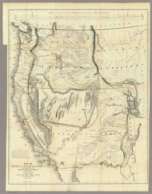
Author
Duflot de Mofras, Eugene
Full Title
Carte De La Cote De L'Amerique Sur L'Ocean Pacifique Septentrional Le Territoire De L'Oregon, Les Californies, La Mer Vermeille, Partie des Territoires de la Compagnie de la Baie d'Hudson, Et De L'Amerique Russe. Dressee par Mr. Duflot de Mofras, Attache a la Legation de France a Mexico; Pour servir a l'intelligence de son Voyage d'exploration Publie Par Ordre Du Roi, sous les Auspices De Mr. Le Marechal Duc De Dalmatie, Mr. Le Ministre Des Affaires Etrangeres. Paris, 1844. Le plan grave par Jacobs. L'ecriture gravee par Hacq. Publie par Arthus Bertrand.
Publisher
Arthus Bertrand
Author
Fremont, J.C.
Full Title
(Title Page to) Report of The Exploring Expedition to The Rocky Mountains in the Year 1842, and to Oregon and North California in the Years 1843-'44.
Publisher
Blair and Rives
Author
Fremont, J.C.
Full Title
Map Of An Exploring Expedition To The Rocky Mountains in the Year 1842, Oregon & North California In The Years 1843-44. By Brevet Capt. J. C. Fremont Of The Corps Of Topographical Engineers Under the orders of Col. J.J. Abert, Chief Of The Topographical Bureau. Lith. by E. Weber & Co. Baltimore, Md.
Publisher
Blair and Rives
Author
Fremont, J.C.
Full Title
(Title Page to) Geographical Memoir upon Upper California In Illustration of His Map of Oregon and California, by John Charles Fremont: Addressed to the Senate of the United States. Washington: Wendell and Van Benthuysen, Printers. 1848. [Senate.] 30th Congress, 1st Session. Miscellaneous. No. 148.
Publisher
Wendell and Van Benthuysen
Author
Fremont, J.C.
Full Title
Map Of Oregon And Upper California From the Surveys of John Charles Fremont And other Authorities. Drawn By Charles Preuss Under the Order of the Senate Of The United States, Washington City 1848. Lithy. by E. Weber & Co. Balto. (inset) Profile of the travelling route from the South Pass of the Rocky Mountains to the Bay of San Francisco.
Publisher
Wendell and Van Benthuysen
Author
Schonberg & Co.
Full Title
Schonberg's Map of California, Oregon & Nevada with Part of Idaho, Utah & Arizona. Entered ... 1866 .. New York.
Publisher
Schonberg & Co.
Author
Vancouver, George, 1757-1798
Full Title
Cote nord-ouest de l'Amerique. Reconnue par le Cape. Vancouver. 2e. partie, depuis 38015' de latitude septle. et 237027' de longitude jusqu'a 45046' de late. et 236015' de longe. (with) Baie de la Trinidad. Voyage de Vancouver. No. 5. (Paris: Depot-general de la Marine, 1828)
Publisher
Depot de la Marine
Author
Mitchell, Samuel Augustus
Full Title
A new map of the State of California, the Territories of Oregon & Utah, and the Chief part of New Mexico. Entered ... 1853, by Thomas, Cowperthwait & Co. ... Pennsylvania.
Publisher
Thomas, Cowperthwait & Co.
Author
Mitchell, Samuel Augustus
Full Title
A new map of the state of California, the territories of Oregon, Washington, Utah and New Mexico. Published by Thomas, Cowperthwait & Co., no. 253 Market Street, Philadelphia. Entered ... 1853 by Thomas, Cowperthwait & Co. ... Pennsylvania.
Publisher
Cowperthwait, Desilver & Butler
Author
U.S. Coast Survey
Full Title
U.S. Coast Survey A.D. Bache, Superintendent Reconnaissance Of The Western Coast Of The United States, Middle Sheet, From San Francisco To Umpquah River. By the Hydrographic Party under the command of Lieut. James Alden U.S.N. Assist. Geographical Positions by G. Davidson Assistant. 1854. Corrected to 1869. Drawn by W.B. McMurtrie; Reduction for engraving by A. Lindenkohl. Engd. by G. McCoy, J. Knight, J.L Hazzard & G.B. Metzeroth. No. 602. Electrotype Copy No. 6 by G. Mathiot U.S.C.S.
Publisher
U.S. Coast Survey
Author
Haven, John
Full Title
Map Of The United States And Mexico, Including Oregon, Texas And The Californias.
Publisher
No. publisher
Author
Ensigns & Thayer
Full Title
Ornamental Map Of The United States & Mexico. Map Of The United States And Mexico Including Oregon, Texas and the Californias. Entered ... 1848, by Ensigns & Thayer ... New York. Published by Ensign & Thayer, 50 Ann Street New York. And 12 Exchange St., Buffalo. Sowle & Ward, 43 Cornhill, Boston. Rufus Blanchard: Cincinatti.
Publisher
[Ensigns & Thayer ; Rufus Blanchard, Sowle & Ward]
Author
Haven, John
Full Title
Map Of The United States And Mexico, Including Oregon, Texas And The Californias.
Publisher
No. publisher
Author
Williamson, R.S.
Full Title
Map of Parts of California, Nevada, Oregon And Idaho Territory, Showing the Routes to the Humboldt And Reese River Mines, Surproise Valley, Owyhee Mines, Idaho, etc. etc. Compiled from the latest Information and comprising the Results of Explorations ... By Bvt. Lieut. Col. R.S. Williamson, U.S.A. Maj. Of Engrs. John D. Hoffmann, C.E. & Topographer, In 1865, Lieut. W.H. Heuer, U.S. Engr. In 1866, U.S. Engineers Office, San Francisco, 1866. Published with Official Consent by Britton & Rey, San Francisco. ... (Reproduction).
Publisher
Britton & Rey
Author
Vancouver, George, 1757-1798
Full Title
A chart shewing part of the Coast of N.W. America, with the tracks of His Majesty's Sloop Discovery and armed tender Chatham, Commanded by George Vancouver Esq. and prepared under his immediate inspection by Lieut. Joseph Baker, in Which the Continental Shore has been finally traced and determined from Latd. 38¼15'N. and Longd. 237¼27'E. to Latd. 45¼46'N. and Longd. 236¼15'E. Engraved by B. Baker Islington. Plate 3. (with) Bay of Trinidad. London, published May 1, 1798 by J. Edwards Pall Mall, and G. Robinson Paternoster Row.
Publisher
G.G. & J. Robinson
Author
Vancouver, George, 1757-1798
Full Title
Views of Parts of the Coast of North West America. 4. W. Alexander delt. from Sketches made on the Spot. London. Published May 1st 1798, by R. Edwards New Bond Street, J. Edwards Pall Mall and G. Robinson Paternoster Row. Engraved by B.T. Pouncy.
Publisher
G.G. & J. Robinson
Author
La Perouse, Jean-Francois de Galaup, comte de, 1741-1788
Full Title
Chart of Part of the North West Coast of America Explored by the Boussole & Astrolabe laid down conformally to the position of the Boussole every day at noon as determinined Astronomically by Mr. Dagelet. Published as the Act directs Novr. 1st 1798, by G.G. & J. Robinson, Paternoster Row. S. Neele, sculpt, Strand. No. 16.
Publisher
G.G. & J. Robinson.
Author
La Perouse, Jean-Francois de Galaup, comte de, 1741-1788
Full Title
Chart of the North West Coast of America. Explored by the Boussole & Astrolabe in 1786. 3d. Sheet. Published as the Act directs Novr. 1st 1798, by G.G. & J. Robinson, Paternoster Row, London. No. 31.
Publisher
G.G. & J. Robinson.
Author
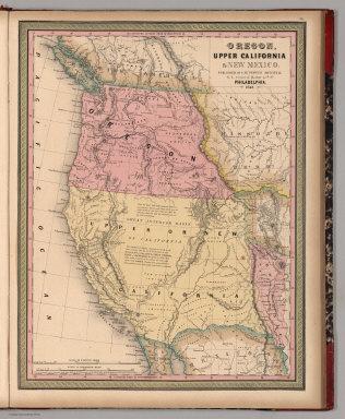
[Bourquin, Frederick, Mitchell, Samuel Augustus, Tanner, Henry S.]
Full Title
Oregon, Upper California & New Mexico. Published by S. Augustus Mitchell, N.E. Corner of Market & 7th. Streets Philadelphia. 1849. Entered according to Act of Congress in the 1845 by H.N. Burroughs - in the Clerk's Office of the Eastern District of Penna. 36.
Publisher
S. Augustus Mitchell.
Author
Mitchell, Samuel Augustus
Full Title
A New Map of the States of California, the Territories of Oregon, Washington, Utah & New Mexico. Published By Charles Desilver, No. 714 Chestnut Street, Philadelphia. Entered according to Act of Congress in the year 1856 by Charles Desilver in the Clerk's office if the District Court of the Eastern District of Pennsylvania. 37.
Publisher
Charles Desilver.
Author
[Abbot, Henry L., Williamson, R.S.]
Full Title
Routes in Oregon and California. Profiles sheet no. 1 from Benicia to Fort Reading and from Fort Reading to Vancouver; from explorations and surveys made under the direction of Hon. Jefferson Davis, Sec. of War by Lieut. R.S. Williamson, U.S. Topl. Engrs. and Lieut. H.L. Abbot, U.S. Topl. Engrs, H.C. Fillerbrown, C.D. Anderson and J. Young assts. 1855. (1861)
Publisher
[A.O.P. Nicholson I-XI, T. Ford XII.]
Author
[Abbot, Henry L., Williamson, R.S.]
Full Title
Routes in Oregon and California. Profiles sheet no. 2 from the head of Des Chutes Valley to Vancouver and from Vancouver to Fort Reading; from explorations and surveys made under the direction of Hon. Jefferson Davis, Sec. of War by Lieut. R.S. Williamson, U.S. Topl. Engrs. and Lieut. H.L. Abbot, U.S. Topl. Engrs, H.C. Fillerbrown, C.D. Anderson and J. Young assts. 1855. (1861)
Publisher
[A.O.P. Nicholson I-XI, T. Ford XII.]
Author
Mitchell, Samuel Augustus
Full Title
(Covers to) A New Map of Texas Oregon and California With The Regions Adjoining. Compiled from the most recent authorities. Philadelphia Published by S. Augustus Mitchell N.E. Corner Of Market & Seventh Streets. 1846. Entered ... 1845 by H.N. Burroughs ... Pennsylvania.
Publisher
S.A. Mitchell
Author
Mitchell, Samuel Augustus
Full Title
Oregon and Upper California. Published by S. Augustus Mitchell, N.E. corner of Market & Seventh Streets. Philadelphia. 1847. Entered according to Act of Congress in the year 1845 by H.N. Burroughs in the ... District Court of the eastern district of Pennsylvania.
Publisher
S.A. Mitchell
Author
Mitchell, Samuel Augustus
Full Title
Oregon, Upper California & New Mexico. Published by S. Augustus Mitchell, N.E. corner of Market & 7th Sts. Philadelphia. 1849. Entered according to Act of Congress in the year 1845 by H.N. Burroughs in the ... District Court of the eastern district of Penna.
Publisher
S.A. Mitchell
Full Title
A new map of the state of California, the territories of Oregon & Utah, and the chief part of New Mexico. Entered according to Act of Congress in the year 1850 by Thomas, Cowperthwait & Co. in the ... District Court of the eastern district of Pennsylvania. (1852)
Publisher
Thomas, Cowperthwait & Co.
Full Title
A new map of the state of California, the territories of Oregon, Washington, Utah and New Mexico. Published by Thomas, Cowperthwait & Co., no. 253 Market Street, Philadelphia. Entered according to Act of Congress in the year 1853 by Thomas, Cowperthwait & Co. in the ... District Court of the eastern district of Pennsylvania. (1854)
Publisher
Cowperthwait, Desilver, Butler
Author
W. & A.K. Johnston Limited
Full Title
California (North), Nevada, Oregon (South). California (South), Nevada (South), Arizona (West).
Publisher
W. & A.K. Johnston Limited
Full Title
A new map of the state of California, the territories of Oregon, Washington, Utah and New Mexico. Published by Charles Desilver, no. 251 Market Street, Philadelphia. Entered according to Act of Congress in the year 1856 by Charles Desilver in the ... District Court of the eastern district of Pennsylvania. (1857)
Publisher
Charles Desilver
Full Title
Map of the state of California, the territories of Oregon & Utah, and the chief part of New Mexico. Entered according to Act of Congress in the year 1851 by Thomas, Cowperthwait & Co. in the ... District Court of the eastern district of Pennsylvania.
Publisher
Thomas, Cowperthwait & Co.
Author
U.S. General Land Office
Full Title
(Map 16 - Washington, Oregon, Montana, Idaho).
Publisher
Julius Bien
Author
Mitchell, Samuel Augustus
Full Title
Oregon, Upper California & New Mexico. Published By S. Augustus Mitchell. N.E. corner of Market & 7th. Sts. Philadelphia. 1849. Entered ... 1845 by H.N. Burroughs ... Penna.
Publisher
S.A. Mitchell
Author
Weber, C.F.
Full Title
Weber's Township And County Map Of California, Nevada And Southern Oregon. Compiled & Drawn from the latest Data 1907. Published by C.F. Weber & Co. New Era Building, Corner Of Sutter And Polk Sts. San Francisco, Ca. 210 N. Main St. Los Angeles, Cal. Copyright, 1907, By C.F. Weber & Co. (inset) Map Of San Francisco And Adjacent Territory. (inset) Map Of Los Angeles And Adjacent Territory.
Publisher
C.F. Weber & Co.
Author
Mitchell, Samuel Augustus
Full Title
Map of the State of California, the Territories of Oregon & Utah, and the Chief Part of New Mexico.
Publisher
Thomas, Cowperthwait & Co.
Author
Mitchell, Samuel Augustus
Full Title
Oregon, Upper California & New Mexico. Published by S. Augustus Mitchell, N.E. corner of Market & 7th Sts. Philadelphia. Entered according to Act of Congress in the year 1845 by H.N. Burroughs in the ... District Court of the eastern district of Penna. (1850)
Publisher
Thomas, Cowperthwait & Co.
Author
Mitchell, Samuel Augustus
Full Title
A new map of the state of California, the territories of Oregon, Washington, Utah and New Mexico. Published by Charles Desilver, no. 251 Market Street, Philadelphia. Entered according to Act of Congress in the year 1856 by Charles Desilver in the ... District Court of the eastern district of Pennsylvania. (1857).
Publisher
Charles DeSilver
Author
[United States. Army. Corps of Engineers, Williamson, R.S.]
Full Title
Topographical map of California, Nevada, Oregon and part of Idaho. Prepared from field surveys and other reliable data. Under the direction of Bvt. Lt. Col. R.S. Williamson, Corps of Engineers, U.S.A. Drawn by W.B. Hyde. 1867.. Julius Bien & Co., Lith., N.Y. (1891-1895)
Publisher
U.S. Government Printing Office
Author
Cornell, S. S. (Sarah S.)
Full Title
Texas. (with) California. Drawn by E. Wells, N.Y. Entered ... 1856, by S.S. Cornell ... Southern District of New York. New York: D. Appleton & Co., 443 & 445 Broadway. (1864)
Publisher
Appleton & Co.
Author
California. State Earthquake Investigation Commission
Full Title
Geomorphic map of California and Nevada with portions of Oregon and Idaho showing the diastrophic character of the relief, the steep descent from the sub-continental shelf to the floor of the Pacific, and the more important known faults. Earthquake Investigation Commission. Drawn by M. Solem. A. Hoen & Co., Baltimore. (Carnegie Institution of Washington, 1908)
Publisher
Carnegie Institution
Author
California. State Earthquake Investigation Commission
Full Title
Map of California and Nevada showing the distribution of apparent intensity in the region affected by the earthquake of April 18, 1906. Drawn by M. Solem. Earthquake Investigation Commission. A. Hoen & Co., Baltimore. (Carnegie Institution of Washington. 1908)
Publisher
Carnegie Institution
Author
Wheeler, G.M.
Full Title
Parts Of N.E. California, N.W. Nevada And Southern Oregon. Atlas Sheet No. 38 B. Issued June 30th, 1882. Weyss, Rock and Karl, Del. Expeditions of 1877 & 1878 Under the Command of 1st Lieut. Geo. M. Wheeler, Corps of Engineers, U.S. Army. U.S. Geographical Surveys West Of The 100th Meridian.
Publisher
U.S.
Author
Mitchell, Samuel Augustus
Full Title
Map of Oregon and Upper California. Engraved to illustrate Mitchell's school and family geography. (with) Map of the Columbia River from the Cascades to the Pacific Ocean. Entered ... 1846 by S.A. Mitchell ... Eastern District of Pennsylvania.
Publisher
Thomas, Cowperthwait & Co.
Author
[Galpin, S. A., United States. Census Office]
Full Title
Maps of the Pacific Coast exhibiting various subjects. Compiled from the statistics of the eight and ninth census of the United States by S.A. Galpin. (Julius Bien, Lith., 1874)
Publisher
U.S.
Full Title
A new map of the state of California, the territories of Oregon, Washington, Utah and New Mexico. Published by Thomas, Cowperthwait & Co., no. 253 Market Street, Philadelphia. Entered according to Act of Congress in the year 1853 by Thomas, Cowperthwait & Co. in the ... District Court of the eastern district of Pennsylvania. (1854)
Publisher
Thomas, Cowperthwait & Co.
Author
Mitchell, Samuel Augustus
Full Title
Oregon and Upper California. Published by S. Augustus Mitchell, N.E. corner of Market & Seventh Streets. Philadelphia. 1846. Entered according to Act of Congress in the year 1845 by H.N. Burroughs in the ... District Court of the eastern district of Pennsylvania. (1847)
Publisher
S.A. Mitchell
|