Browse All

1844 Cover: Exploration du Territoire de L'Or … Exploration Book (Covers to) Exploration Du Territoire De … |

1844 Half Title: Exploration du Territoire de … Exploration Book (Half Title Page to) Exploration Du Terr … |

1844 Title Page: Exploration du Territoire de … Exploration Book (Title Page to) Exploration Du Territoir … |

1844 Index: Exploration du Territoire de l'Or … Exploration Book (Index to) Exploration Du Territoire De … |

1844 Carte De La Cote De L'Amerique. Exploration Book Carte De La Cote De L'Amerique Sur L'Oce … |

1845 Title Page: Report of the Exploring Expe … Exploration Book (Title Page to) Report of The Exploring … |

1845 Map Of An Exploring Expedition To The Ro … Exploration Book Map Of An Exploring Expedition To The Ro … |

1848 Title Page: Geographical memoir upon Upp … Exploration Book (Title Page to) Geographical Memoir upon … |
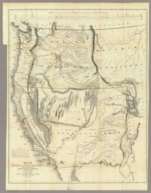
1848 Map Of Oregon And Upper California. Exploration Book Map Of Oregon And Upper California From … |

1867 California, Oregon & Nevada with Part of … National Atlas Schonberg's Map of California, Oregon & … |

1828 Cote NO, l'Amerique 2. Chart Atlas Cote nord-ouest de l'Amerique. Reconnue … |

1853 California, Oregon, Utah, New Mexico World Atlas A new map of the State of California, th … |

1855 California, Oregon, Washington, Utah and … World Atlas A new map of the state of California, th … |

1869 Western Coast Of The United States Chart Map U.S. Coast Survey A.D. Bache, Superinten … |

1846 Map Of The United States, Mexico, Oregon … Separate Map Map Of The United States And Mexico, Inc … |

1848 Map Of The United States And Mexico Separate Map Ornamental Map Of The United States & Me … |

1846 Map Of The United States, Mexico, Oregon … Separate Map Map Of The United States And Mexico, Inc … |

1866 Map of Parts of California, Nevada, Oreg … Separate Map Map of Parts of California, Nevada, Oreg … |

1798 The Coast of N.W. America Chart Atlas A chart shewing part of the Coast of N.W … |

1798 Views of Parts of the Coast of North Wes … Chart Atlas Views of Parts of the Coast of North Wes … |

1799 Chart of Part of the North West Coast of … Exploration Book Chart of Part of the North West Coast of … |

1799 Chart of the North West Coast of America … Exploration Book Chart of the North West Coast of America … |

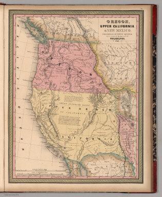
1848 Oregon, Upper California & New Mexico. World Atlas Oregon, Upper California & New Mexico. P … |

1859 California, Territories of Oregon, Washi … World Atlas A New Map of the States of California, t … |

1861 Profiles 1 Benicia-Ft. Reading & Ft. For … Exploration Book Routes in Oregon and California. Profile … |

1861 Profiles 2 Des Chutes Valley-Vancouver & … Exploration Book Routes in Oregon and California. Profile … |

1846 Cover: Texas, Oregon and California. Pocket Map (Covers to) A New Map of Texas Oregon an … |

1847 Oregon & Upper California. World Atlas Oregon and Upper California. Published b … |

1849 Oregon, Upper California & New Mexico. World Atlas Oregon, Upper California & New Mexico. P … |

1852 California, Oregon, Utah, New Mexico. World Atlas A new map of the state of California, th … |

1854 California, Oregon, Washington, Utah, Ne … World Atlas A new map of the state of California, th … |

1906 California, Nevada, Oregon (South). Neva … World Atlas California (North), Nevada, Oregon (Sout … |

1857 California, Oregon, Washington, Utah, Ne … World Atlas A new map of the state of California, th … |

1851 California, Oregon, Utah, New Mexico. World Atlas Map of the state of California, the terr … |

1878 (Map 16 - Washington, Oregon, Montana, I … Case Map (Map 16 - Washington, Oregon, Montana, I … |
1849 Oregon, Upper California & New Mexico World Atlas Oregon, Upper California & New Mexico. P … |

1907 Map Of California, Nevada And Southern O … Wall Map Weber's Township And County Map Of Calif … |

1850 California, Oregon, Utah and New Mexico. World Atlas Map of the State of California, the Terr … |

1850 Oregon, Upper California & New Mexico. World Atlas Oregon, Upper California & New Mexico. P … |

1857 California, Oregon, Washington, Utah, Ne … World Atlas A new map of the state of California, th … |

1895 California, Nevada, Oregon. Military Atlas Topographical map of California, Nevada, … |

1864 Texas, California. School Atlas Texas. (with) California. Drawn by E. We … |

1908 Geomorphic map, California, Nevada, port … Physical Atlas Geomorphic map of California and Nevada … |

1908 California, Nevada showing intensity. Physical Atlas Map of California and Nevada showing the … |

1882 38B. Parts Of N.E. California, N.W. Neva … National Atlas Parts Of N.E. California, N.W. Nevada An … |

1847 Oregon, Upper California. School Atlas Map of Oregon and Upper California. Engr … |

1874 Pacific Coast subjects. Statistical Atlas Maps of the Pacific Coast exhibiting var … |

1854 California, Oregon, Washington, Utah, Ne … World Atlas A new map of the state of California, th … |

1846 Oregon & Upper California. World Atlas Oregon and Upper California. Published b … |

1896 Pacific Coast Steamship Company. Timetable Map Map showing routes of the Pacific Coast … |