Who What Where WhenWHO
WHEN |
REFINE
Browse All : Images of Oregon from 1900
1-16 of 16
Author
[USGS (U.S. Geological Survey), Walcott, Charles D., Gannett, Henry, Leiberg, John B., Thompson, A.H.]
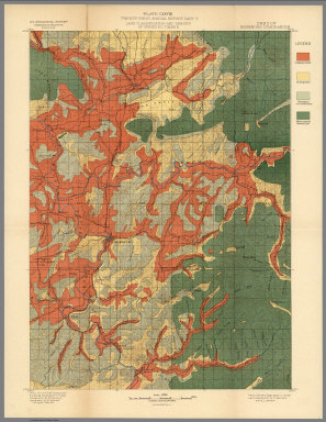
Full Title
Plate LXXII. Klamath Quadrangle, Oregon. Land Classification and Density of Standing Timber. Julius Bien & Co. Lith. N.Y.
Publisher
Government Printing Office
Author
[USGS (U.S. Geological Survey), Walcott, Charles D., Leiberg, John B.]
Full Title
(View) Plate LXXIII. A. Summit of Siskiyou Mountains, near Sterling Peak. B. Summit of Umpqua Divides, Looking Northeast from Abbots Butte.
Publisher
Government Printing Office
Author
[USGS (U.S. Geological Survey), Walcott, Charles D., Leiberg, John B.]
Full Title
(View) Plate LXXV. A. B. Yellow-Pine Type of Forest, near Johnson Prairie, Western Slope of Cascades.
Publisher
Government Printing Office
Author
[USGS (U.S. Geological Survey), Walcott, Charles D., Leiberg, John B.]
Full Title
(View) Plate LXXVII. A. Yellow-Pine Type of Forest East Side of Williamson River, Upper Klamath River Basin. B. Burnt Yellow Pine, Rogue River Valley, Near Mill Creek.
Publisher
Government Printing Office
Author
[USGS (U.S. Geological Survey), Walcott, Charles D., Leiberg, John B.]
Full Title
(View) Plate LXXVIII. Group of Red Firs, Rogue River Valley, near Mill Creek.
Publisher
Government Printing Office
Author
[USGS (U.S. Geological Survey), Walcott, Charles D., Leiberg, John B.]
Full Title
(View) Plate LXXIX. A. B. Burnt Alpine Hemlock, Noble Fir, and Lodgepole Pine, near Head of North Fork of Rogue River.
Publisher
Government Printing Office
Author
[USGS (U.S. Geological Survey), Walcott, Charles D., Leiberg, John B.]
Full Title
(View) Plate LXXXI. A. Logging Tracks and Load, near Snow. B. Method used in Hauling Logs to the Logging Railroad at Snow.
Publisher
Government Printing Office
Author
[USGS (U.S. Geological Survey), Walcott, Charles D., Leiberg, John B.]
Full Title
Plate LXXXII. Part of Southern Oregon Showing Distribution of Yellow Pine and White Bark Pine.
Publisher
Government Printing Office
Author
[USGS (U.S. Geological Survey), Walcott, Charles D., Leiberg, John B.]
Full Title
(View) Plate LXXXIII. A. Mount Pitt, from West End of Pelican Bay, Upper Klamath Lake. B. Mount Pitt, as Seen from Fish Lake.
Publisher
Government Printing Office
Author
[USGS (U.S. Geological Survey), Walcott, Charles D.]
Full Title
Plate CXXVI. Port Orford Quadrangle, Oregon, Land Classification and Density of Standing Timber.
Publisher
Government Printing Office
Author
[USGS (U.S. Geological Survey), Walcott, Charles D., Gannett, Henry]
Full Title
Plate CXXVII. Coos Bay Quadrangle, Oregon, Land Classification and Density of Standing Timber.
Publisher
Government Printing Office
Author
[USGS (U.S. Geological Survey), Walcott, Charles D., Gannett, Henry]
Full Title
Plate CXXVIII. Roseburg Quadrangle, Oregon, Land Classification and Density of Standing Timber.
Publisher
Government Printing Office
Author
[USGS (U.S. Geological Survey), Walcott, Charles D., Gannett, Henry, Leiberg, John B.]
Full Title
Plate LXXIV. Part of Southern Oregon Showing Distribution of Sugar Pine, Noble Fir, Western Hemlock, Incense Cedar by John B. Leiberg. 1899.
Publisher
Government Printing Office
Author
[USGS (U.S. Geological Survey), Walcott, Charles D., Gannett, Henry, Leiberg, John B.]
Full Title
Plate LXXVI. Part of Southern Oregon Showing Distribution of Red Fir, and Alpine Hemlock by John B. Leiberg. 1899.
Publisher
Government Printing Office
Author
[USGS (U.S. Geological Survey), Walcott, Charles D., Gannett, Henry, Leiberg, John B.]
Full Title
Plate LXXX. Part of Southern Oregon Showing Distribution of White Fir. By John B. Leiberg. 1899.
Publisher
Government Printing Office
Author
[USGS (U.S. Geological Survey), Walcott, Charles D., Gannett, Henry, Leiberg, John B.]
Full Title
Plate LXXXIV. Part of Southern Oregon Showing Distribution of Lodgepole Pine by John B. Leiberg. 1899.
Publisher
Government Printing Office
1-16 of 16
|