Browse All

1965 Northwest United States -- Physical Wall Map Pacific Northwest. |

1987 Oregon -- Physical Wall Map Oregon. |

1865 Map of Oregon, Washington, Idaho, and Pa … World Atlas Map of Oregon, Washington, Idaho, and Pa … |

1907 Map Of California, Nevada And Southern O … Wall Map Weber's Township And County Map Of Calif … |

1874 Map of Oregon, washington, Idaho, and pa … World Atlas Map of Oregon, Washington, Idahoe, and p … |

1891 Sectional map of Washington, Oregon, Ida … Separate Map C.H. Amerine's : Sectional map of Washin … |

1850 California, Oregon, Utah and New Mexico. World Atlas Map of the State of California, the Terr … |

1850 Oregon, Upper California & New Mexico. World Atlas Oregon, Upper California & New Mexico. P … |

1857 California, Oregon, Washington, Utah, Ne … World Atlas A new map of the state of California, th … |

1877 Map of Oregon, Washington, Idaho and par … World Atlas Map of Oregon, Washington, Idaho and par … |

1868 Map of Oregon, Washington, Idaho, and pa … World Atlas Map of Oregon, Washington, Idaho, and pa … |

1860 Washington And Oregon. World Atlas Johnson's Washington And Oregon By Johns … |

1927 Oregon National Atlas Oregon. (Copyrighted by) National Map Co … |

1857 Territories Of Washington And Oregon. National Atlas Territories Of Washington And Oregon. By … |

1895 California, Nevada, Oregon. Military Atlas Topographical map of California, Nevada, … |

1864 Texas, California. School Atlas Texas. (with) California. Drawn by E. We … |

1908 Geomorphic map, California, Nevada, port … Physical Atlas Geomorphic map of California and Nevada … |

1908 California, Nevada showing intensity. Physical Atlas Map of California and Nevada showing the … |

1882 38B. Parts Of N.E. California, N.W. Neva … National Atlas Parts Of N.E. California, N.W. Nevada An … |

1873 Oregon, and the Territory of Washington. State Atlas Atlas of the United States. Oregon, and … |

1847 Oregon, Upper California. School Atlas Map of Oregon and Upper California. Engr … |

1929 Legend: 138-39. Wash., Ore., Ida. World Atlas (Legend to) Stati Uniti, United States o … |

1929 138-39. Wash., Ore., Ida. World Atlas Stati Uniti, United States of America, W … |

1880 Ore., Wash., Ida., Mont. World Atlas Map of Oregon, Washington, Idaho, and pa … |

1890 Oregon, Washington. World Atlas County and township map of Oregon and Wa … |

1874 Pacific Coast subjects. Statistical Atlas Maps of the Pacific Coast exhibiting var … |

1870 Ore., Wash., Idaho, Mont. [State Atlas, World Atlas] Map of Oregon, Washington, Idaho, and pa … |

1840 Oregon Territory. World Atlas Oregon Territory. |

1946 Rogue River Outlet. [Aerial Photographs, Regional Atlas] Rogue River outlet. |

1946 Rogue River Outlet. [Aerial Photographs, Regional Atlas] Rogue River. |

1946 Port Orford. [Aerial Photographs, Regional Atlas] Port Orford. |
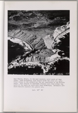
1946 Cape Blanco. [Aerial Photographs, Regional Atlas] Cape Blanco. |

1946 Cape Blanco. [Aerial Photographs, Regional Atlas] Cape Blanco. |

1946 Bandon. Coquille River. [Aerial Photographs, Regional Atlas] Bandon. Coquille River. |

1946 Bandon. Coquille River. [Aerial Photographs, Regional Atlas] Bandon. Coquille River. |

1946 Cape Arago. [Aerial Photographs, Regional Atlas] Cape Arago. |

1946 Coos Bay Entrance. [Aerial Photographs, Regional Atlas] Coos Bay Entrance. |

1946 Umpqua River entrance. [Aerial Photographs, Regional Atlas] Umpqua River entrance. |

1854 California, Oregon, Washington, Utah, Ne … World Atlas A new map of the state of California, th … |

1946 Umpqua River. Winchester Bay. [Aerial Photographs, Regional Atlas] Umpqua River. Winchester Bay. |

1946 Siuslaw River. Munsel Lake. [Aerial Photographs, Regional Atlas] Siuslaw River. Munsel Lake. |

1946 Alsea River Entrance. [Regional Atlas, Aerial Photographs] Alsea River Entrance. |

1946 Yaquina Bay. [Aerial Photographs, Regional Atlas] Yaquina Bay. |

1946 Yaquina Bay Entrance. [Regional Atlas, Aerial Photographs] Yaquina Bay Entrance. |

1946 Yaquina Head. [Aerial Photographs, Regional Atlas] Yaquina Head. |

1946 Yaquina Head. [Aerial Photographs, Regional Atlas] Yaquina Head. |

1946 Whale Cove. [Aerial Photographs, Regional Atlas] Whale Cove. |

1946 Depoe Bay, Cape Foulweather. [Aerial Photographs, Regional Atlas] Depoe Bay, Cape Foulweather. |

1946 Siletz Bay. [Aerial Photographs, Regional Atlas] Siletz Bay. |

1946 Salmon River Entrance. [Aerial Photographs, Regional Atlas] Salmon River Entrance. |