Who What Where WhenREMOVEWHERE
|
Author
[Smith, Ronald, Babcock, Chester]
Full Title
Pacific Northwest.
Publisher
AJ Nystrom & Co
Author
[United States Geological Survey (USGS), Allan Cartography, Raven Maps and Imaging]
Full Title
Oregon.
Publisher
Pikes Peak Lithographing
Author
Mitchell, Samuel Augustus Jr.
Full Title
Map of Oregon, Washington, Idaho, and Part of Montana. Entered ... 1860 by S. Augustus Mitchell, Jr. ... Pennsylvania.
Publisher
S.A. Mitchell Jr.
Author
Weber, C.F.
Full Title
Weber's Township And County Map Of California, Nevada And Southern Oregon. Compiled & Drawn from the latest Data 1907. Published by C.F. Weber & Co. New Era Building, Corner Of Sutter And Polk Sts. San Francisco, Ca. 210 N. Main St. Los Angeles, Cal. Copyright, 1907, By C.F. Weber & Co. (inset) Map Of San Francisco And Adjacent Territory. (inset) Map Of Los Angeles And Adjacent Territory.
Publisher
C.F. Weber & Co.
Author
Mitchell, Samuel Augustus Jr.
Full Title
Map of Oregon, Washington, Idahoe, and part of Montana. Entered ... 1874, by S. Augustus Mitchell ... Washington.
Publisher
S.A. Mitchell Jr.
Author
Amerine, C.H.
Full Title
C.H. Amerine's : Sectional map of Washington, Oregon, Idaho, and western Montana. Compiled from latest official data exploration and other sources. Compiled and published by C.H. Amerine, 1891. Copyrighted by C.H. Amerine, Tacoma, Wash. Photo - Litho by Schmidt Lable & Lith Co. S.F.
Publisher
[C.H.Amerine, Schmidt Lable & Lith Co.]
Author
Mitchell, Samuel Augustus
Full Title
Map of the State of California, the Territories of Oregon & Utah, and the Chief Part of New Mexico.
Publisher
Thomas, Cowperthwait & Co.
Author
Mitchell, Samuel Augustus
Full Title
Oregon, Upper California & New Mexico. Published by S. Augustus Mitchell, N.E. corner of Market & 7th Sts. Philadelphia. Entered according to Act of Congress in the year 1845 by H.N. Burroughs in the ... District Court of the eastern district of Penna. (1850)
Publisher
Thomas, Cowperthwait & Co.
Author
Mitchell, Samuel Augustus
Full Title
A new map of the state of California, the territories of Oregon, Washington, Utah and New Mexico. Published by Charles Desilver, no. 251 Market Street, Philadelphia. Entered according to Act of Congress in the year 1856 by Charles Desilver in the ... District Court of the eastern district of Pennsylvania. (1857).
Publisher
Charles DeSilver
Author
Mitchell, Samuel Augustus Jr.
Full Title
Map of Oregon, Washington, Idaho and part of Montana. Entered ... 1877 by S. Augustus Mitchell, . ... Washington.
Publisher
S.A. Mitchell Jr.
Author
Mitchell, Samuel Augustus Jr.
Full Title
Map of Oregon, Washington, Idaho, and part of Montana. Entered ... 1867 by S. Augustus Mitchell, Jr. ... Pennsylvania.
Publisher
S.A. Mitchell Jr.
Author
Johnson, A.J.
Full Title
Johnson's Washington And Oregon By Johnson & Browning. No. 46.
Publisher
Johnson and Browning
Author
National Map Company
Full Title
Oregon. (Copyrighted by) National Map Company, Indianapolis. (to accompany) Official Paved Road and Commercial Survey of the United States.
Publisher
National Map Company
Author
[Johnston, Alexander Keith, 1804-1871, Rogers, Henry Darwin]
Full Title
Territories Of Washington And Oregon. By Prof. H.D. Rogers & A. Keith Johnston, F.R.S.E. Entered in Sta. Hall. London ... & according to an act of Congress ... 1857, by H.D. Rogers ... Massachusetts. London, John Murray, Albemarle Street, Edinburgh, W. & A.K. Johnston. Engraved by W. & A.K. Johnston, Edinburgh.
Publisher
Edward Stanford
Author
[United States. Army. Corps of Engineers, Williamson, R.S.]
Full Title
Topographical map of California, Nevada, Oregon and part of Idaho. Prepared from field surveys and other reliable data. Under the direction of Bvt. Lt. Col. R.S. Williamson, Corps of Engineers, U.S.A. Drawn by W.B. Hyde. 1867.. Julius Bien & Co., Lith., N.Y. (1891-1895)
Publisher
U.S. Government Printing Office
Author
Cornell, S. S. (Sarah S.)
Full Title
Texas. (with) California. Drawn by E. Wells, N.Y. Entered ... 1856, by S.S. Cornell ... Southern District of New York. New York: D. Appleton & Co., 443 & 445 Broadway. (1864)
Publisher
Appleton & Co.
Author
California. State Earthquake Investigation Commission
Full Title
Geomorphic map of California and Nevada with portions of Oregon and Idaho showing the diastrophic character of the relief, the steep descent from the sub-continental shelf to the floor of the Pacific, and the more important known faults. Earthquake Investigation Commission. Drawn by M. Solem. A. Hoen & Co., Baltimore. (Carnegie Institution of Washington, 1908)
Publisher
Carnegie Institution
Author
California. State Earthquake Investigation Commission
Full Title
Map of California and Nevada showing the distribution of apparent intensity in the region affected by the earthquake of April 18, 1906. Drawn by M. Solem. Earthquake Investigation Commission. A. Hoen & Co., Baltimore. (Carnegie Institution of Washington. 1908)
Publisher
Carnegie Institution
Author
Wheeler, G.M.
Full Title
Parts Of N.E. California, N.W. Nevada And Southern Oregon. Atlas Sheet No. 38 B. Issued June 30th, 1882. Weyss, Rock and Karl, Del. Expeditions of 1877 & 1878 Under the Command of 1st Lieut. Geo. M. Wheeler, Corps of Engineers, U.S. Army. U.S. Geographical Surveys West Of The 100th Meridian.
Publisher
U.S.
Author
Lloyd, H.H.
Full Title
Atlas of the United States. Oregon, and the Territory of Washington. (by H.H. Lloyd. Published by Stedman, Brown & Lyon, Baltimore. 1873)
Publisher
Stedman, Brown & Lyon
Author
Mitchell, Samuel Augustus
Full Title
Map of Oregon and Upper California. Engraved to illustrate Mitchell's school and family geography. (with) Map of the Columbia River from the Cascades to the Pacific Ocean. Entered ... 1846 by S.A. Mitchell ... Eastern District of Pennsylvania.
Publisher
Thomas, Cowperthwait & Co.
Author
Touring club italiano
Full Title
(Legend to) Stati Uniti, United States of America, Washington, Oregon, Idaho. Propr. Artistico-letteraria del T.C.I. Ufficio cartografico del T.C.I. (1929)
Publisher
Touring club italiano
Author
Touring club italiano
Full Title
Stati Uniti, United States of America, Washington, Oregon, Idaho. Propr. Artistico-letteraria del T.C.I. Ufficio cartografico del T.C.I. (1929)
Publisher
Touring club italiano
Author
Mitchell, Samuel Augustus
Full Title
Map of Oregon, Washington, Idaho, and part of Montana. Entered ... 1879 by S. Augustus Mitchell ... Washington. (1880)
Publisher
S.A. Mitchell
Full Title
County and township map of Oregon and Washington. Copyright 1887 by Wm. M. Bradley & Bro. (1890)
Publisher
John Y. Huber & Co.
Author
[Galpin, S. A., United States. Census Office]
Full Title
Maps of the Pacific Coast exhibiting various subjects. Compiled from the statistics of the eight and ninth census of the United States by S.A. Galpin. (Julius Bien, Lith., 1874)
Publisher
U.S.
Author
Mitchell, Samuel Augustus
Full Title
Map of Oregon, Washington, Idaho, and part of Montana. Entered ... 1870 by S. Augustus Mitchell, Jr. ... Pennsylvania.
Publisher
[R.A. Campbell, S.A. Mitchell, Jr.]
Author
Greenleaf, Jeremiah
Full Title
Oregon Territory.
Publisher
G.R. French
Author
[Isaacs, John D., Bascom]
Full Title
Rogue River outlet.
Publisher
Department of Engineering, University of California
Author
[Isaacs, John D., Bascom]
Full Title
Rogue River.
Publisher
Department of Engineering, University of California
Author
[Isaacs, John D., Bascom]
Full Title
Port Orford.
Publisher
Department of Engineering, University of California
Author
[Isaacs, John D., Bascom]
Full Title
Cape Blanco.
Publisher
Department of Engineering, University of California
Author
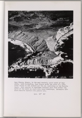
[Isaacs, John D., Bascom]
Full Title
Cape Blanco.
Publisher
Department of Engineering, University of California
Author
[Isaacs, John D., Bascom]
Full Title
Bandon. Coquille River.
Publisher
Department of Engineering, University of California
Author
[Isaacs, John D., Bascom]
Full Title
Bandon. Coquille River.
Publisher
Department of Engineering, University of California
Author
[Isaacs, John D., Bascom]
Full Title
Cape Arago.
Publisher
Department of Engineering, University of California
Author
[Isaacs, John D., Bascom]
Full Title
Coos Bay Entrance.
Publisher
Department of Engineering, University of California
Author
[Isaacs, John D., Bascom]
Full Title
Umpqua River entrance.
Publisher
Department of Engineering, University of California
Full Title
A new map of the state of California, the territories of Oregon, Washington, Utah and New Mexico. Published by Thomas, Cowperthwait & Co., no. 253 Market Street, Philadelphia. Entered according to Act of Congress in the year 1853 by Thomas, Cowperthwait & Co. in the ... District Court of the eastern district of Pennsylvania. (1854)
Publisher
Thomas, Cowperthwait & Co.
Author
[Isaacs, John D., Bascom]
Full Title
Umpqua River. Winchester Bay.
Publisher
Department of Engineering, University of California
Author
[Isaacs, John D., Bascom]
Full Title
Siuslaw River. Munsel Lake.
Publisher
Department of Engineering, University of California
Author
[Isaacs, John D., Bascom]
Full Title
Alsea River Entrance.
Publisher
Department of Engineering, University of California
Author
[Isaacs, John D., Bascom]
Full Title
Yaquina Bay.
Publisher
Department of Engineering, University of California
Author
[Isaacs, John D., Bascom]
Full Title
Yaquina Bay Entrance.
Publisher
Department of Engineering, University of California
Author
[Isaacs, John D., Bascom]
Full Title
Yaquina Head.
Publisher
Department of Engineering, University of California
Author
[Isaacs, John D., Bascom]
Full Title
Yaquina Head.
Publisher
Department of Engineering, University of California
Author
[Isaacs, John D., Bascom]
Full Title
Whale Cove.
Publisher
Department of Engineering, University of California
Author
[Isaacs, John D., Bascom]
Full Title
Depoe Bay, Cape Foulweather.
Publisher
Department of Engineering, University of California
Author
[Isaacs, John D., Bascom]
Full Title
Siletz Bay.
Publisher
Department of Engineering, University of California
|