Who What Where WhenREMOVEWHAT
|
Author
[Isaacs, John D., Bascom]
Full Title
Nestucca River Entrance.
Publisher
Department of Engineering, University of California
Author
[Isaacs, John D., Bascom]
Full Title
Pacific City, Haystack Rock, Cape Kiwanda.
Publisher
Department of Engineering, University of California
Author
[Isaacs, John D., Bascom]
Full Title
Sand Lake Entrance.
Publisher
Department of Engineering, University of California
Author
[Isaacs, John D., Bascom]
Full Title
Cape Lookout.
Publisher
Department of Engineering, University of California
Author
[Isaacs, John D., Bascom]
Full Title
Netarts Bay.
Publisher
Department of Engineering, University of California
Author
[Isaacs, John D., Bascom]
Full Title
Tillamook Bay Entrance.
Publisher
Department of Engineering, University of California
Author
[Isaacs, John D., Bascom]
Full Title
Nehalem entrance.
Publisher
Department of Engineering, University of California
Author
[Isaacs, John D., Bascom]
Full Title
Nehalem River.
Publisher
Department of Engineering, University of California
Author
[Isaacs, John D., Bascom]
Full Title
Smugglers Cove.
Publisher
Department of Engineering, University of California
Author
[Isaacs, John D., Bascom]
Full Title
Nehkahnie Mountain, Smugglers Cove.
Publisher
Department of Engineering, University of California
Author
[Isaacs, John D., Bascom]
Full Title
Catsops Plain. Tillamook Head.
Publisher
Department of Engineering, University of California
Author
[Isaacs, John D., Bascom]
Full Title
Columbia River Entrance, Cape Disappointment.
Publisher
Department of Engineering, University of California
Author
[Isaacs, John D., Bascom]
Full Title
Clatsop Spit, Columbia River Estuary.
Publisher
Department of Engineering, University of California
Author
[Isaacs, John D., Bascom]
Full Title
Peacock Spit, Columbia River.
Publisher
Department of Engineering, University of California
Author
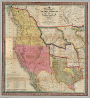
Mitchell, Samuel Augustus
Full Title
Oregon and Upper California. Published by S. Augustus Mitchell, N.E. corner of Market & Seventh Streets. Philadelphia. 1846. Entered according to Act of Congress in the year 1845 by H.N. Burroughs in the ... District Court of the eastern district of Pennsylvania. (1847)
Publisher
S.A. Mitchell
Author
Pacific Coast Steamship Co.
Full Title
Map showing routes of the Pacific Coast Steamship Company. Rand, McNally & Co., engr's, Chicago.
Publisher
Rand McNally
Author
Pacific Coast Steamship Co.
Full Title
(Covers to) Pacific Coast Steamship Co. February to May 1896, Inc. ... Goodall Perkins & Co. General Agents, 10 Market Street, San Francisco, Cal. Ticket Office 4 New Montgomery St. Palace Hotel, San Francisco, Cal.
Publisher
Rand McNally
Author
Pacific Coast Steamship Co.
Full Title
(Text Page to) Pacific Coast Steamship Co. February to May 1896, Inc. ... Goodall Perkins & Co. General Agents, 10 Market Street, San Francisco, Cal. Ticket Office 4 New Montgomery St. Palace Hotel, San Francisco, Cal.
Publisher
Rand McNally
Full Title
A new map of the state of California, the territories of Oregon, Washington, Utah and New Mexico. Published by Charles Desilver, no. 251 Market Street, Philadelphia. Entered according to Act of Congress in the year 1856 by Charles Desilver in the ... District Court of the eastern district of Pennsylvania. (1857)
Publisher
Charles Desilver
Author
Mitchell, Samuel Augustus
Full Title
A New Map of Texas Oregon and California With The Regions Adjoining. Compiled from the most recent authorities. Philadelphia Published by S. Augustus Mitchell N.E. Corner Of Market & Seventh Streets. 1846. Entered ... 1845 by H.N. Burroughs ... Pennsylvania.
Publisher
S.A. Mitchell
Full Title
A new map of the state of California, the territories of Oregon, Washington, Utah and New Mexico. Published by Charles Desilver, no. 253 Market Street, Philadelphia. Entered according to Act of Congress in the year 1850 by Thomas, Cowperthwait & Co. in the ... District Court of the eastern district of Pennsylvania. (1855)
Publisher
Cowperthwait, Desilver, Butler
Author
[E.P. Noll & Co., J.K. Gill Company]
Full Title
Map of the state of Oregon. Published by the J.K. Gill Company, Portland, Oregon. Copyright, 1911, the J.K. Gill Company. E.P. Noll & Co. Map Publishers, Phila, Pa.
Publisher
J.K. Gill Company
Author
[E.P. Noll & Co., J.K. Gill Company]
Full Title
(Covers to) Map of the state of Oregon. Published by the J.K. Gill Company, Portland, Oregon. Copyright, 1911, the J.K. Gill Company. E.P. Noll & Co. Map Publishers, Phila, Pa.
Publisher
J.K. Gill Company
Author
Northern Pacific Railroad Company
Full Title
Map showing land grant of the Northern Pacific Railroad Co. in Western Washington and Northern Oregon. Corrected up to August 20, 1888 ... Matthews, Northrup & Co., Art-Printing Works, Buffalo, N.Y. (inset map) Northern Pacific Railroad and connections.
Publisher
Matthews, Northrup & Co.
Author
Northern Pacific Railroad Company
Full Title
(Covers to) Map showing land grant of the Northern Pacific Railroad Co. in Western Washington and Northern Oregon. Corrected up to August 20, 1888 ... Matthews, Northrup & Co., Art-Printing Works, Buffalo, N.Y.
Publisher
Matthews, Northrup & Co.
Author
Northern Pacific Railroad Company
Full Title
(Text Page to) Map showing land grant of the Northern Pacific Railroad Co. in Western Washington and Northern Oregon. Corrected up to August 20, 1888 ... Matthews, Northrup & Co., Art-Printing Works, Buffalo, N.Y.
Publisher
Matthews, Northrup & Co.
Author
[USGS (U.S. Geological Survey), Walcott, Charles D., Gannett, Henry, Leiberg, John B., Thompson, A.H.]
Full Title
Plate LXXII. Klamath Quadrangle, Oregon. Land Classification and Density of Standing Timber. Julius Bien & Co. Lith. N.Y.
Publisher
Government Printing Office
Author
[USGS (U.S. Geological Survey), Walcott, Charles D., Leiberg, John B.]
Full Title
(View) Plate LXXIII. A. Summit of Siskiyou Mountains, near Sterling Peak. B. Summit of Umpqua Divides, Looking Northeast from Abbots Butte.
Publisher
Government Printing Office
Author
[USGS (U.S. Geological Survey), Walcott, Charles D., Gannett, Henry, Leiberg, John B.]
Full Title
Plate LXXIV. Part of Southern Oregon Showing Distribution of Sugar Pine, Noble Fir, Western Hemlock, Incense Cedar by John B. Leiberg. 1899.
Publisher
Government Printing Office
Author
[USGS (U.S. Geological Survey), Walcott, Charles D., Leiberg, John B.]
Full Title
(View) Plate LXXV. A. B. Yellow-Pine Type of Forest, near Johnson Prairie, Western Slope of Cascades.
Publisher
Government Printing Office
Author
[USGS (U.S. Geological Survey), Walcott, Charles D., Gannett, Henry, Leiberg, John B.]
Full Title
Plate LXXVI. Part of Southern Oregon Showing Distribution of Red Fir, and Alpine Hemlock by John B. Leiberg. 1899.
Publisher
Government Printing Office
Author
[USGS (U.S. Geological Survey), Walcott, Charles D., Leiberg, John B.]
Full Title
(View) Plate LXXVII. A. Yellow-Pine Type of Forest East Side of Williamson River, Upper Klamath River Basin. B. Burnt Yellow Pine, Rogue River Valley, Near Mill Creek.
Publisher
Government Printing Office
Author
[USGS (U.S. Geological Survey), Walcott, Charles D., Leiberg, John B.]
Full Title
(View) Plate LXXVIII. Group of Red Firs, Rogue River Valley, near Mill Creek.
Publisher
Government Printing Office
Author
[USGS (U.S. Geological Survey), Walcott, Charles D., Leiberg, John B.]
Full Title
(View) Plate LXXIX. A. B. Burnt Alpine Hemlock, Noble Fir, and Lodgepole Pine, near Head of North Fork of Rogue River.
Publisher
Government Printing Office
Author
[USGS (U.S. Geological Survey), Walcott, Charles D., Gannett, Henry, Leiberg, John B.]
Full Title
Plate LXXX. Part of Southern Oregon Showing Distribution of White Fir. By John B. Leiberg. 1899.
Publisher
Government Printing Office
Author
[USGS (U.S. Geological Survey), Walcott, Charles D., Leiberg, John B.]
Full Title
(View) Plate LXXXI. A. Logging Tracks and Load, near Snow. B. Method used in Hauling Logs to the Logging Railroad at Snow.
Publisher
Government Printing Office
Author
[USGS (U.S. Geological Survey), Walcott, Charles D., Leiberg, John B.]
Full Title
Plate LXXXII. Part of Southern Oregon Showing Distribution of Yellow Pine and White Bark Pine.
Publisher
Government Printing Office
Author
[USGS (U.S. Geological Survey), Walcott, Charles D., Leiberg, John B.]
Full Title
(View) Plate LXXXIII. A. Mount Pitt, from West End of Pelican Bay, Upper Klamath Lake. B. Mount Pitt, as Seen from Fish Lake.
Publisher
Government Printing Office
Author
[USGS (U.S. Geological Survey), Walcott, Charles D., Gannett, Henry, Leiberg, John B.]
Full Title
Plate LXXXIV. Part of Southern Oregon Showing Distribution of Lodgepole Pine by John B. Leiberg. 1899.
Publisher
Government Printing Office
Author
[H.M. Gousha Company, Standard Oil Company of California]
Full Title
1935 road map Oregon. Prepared exclusively for Standard Oil Company of California. Copyrighted by the H.M. Gousha Company, Chicago, Ill. Made in U.S.A. Standard unsurpassed gasoline ...
Publisher
The H.M. Gousha Company
Author
[H.M. Gousha Company, Standard Oil Company of California]
Full Title
1935 road map Western United States prepared exclusively for Standard Oil Company of California ... (with 5 inset maps).
Publisher
The H.M. Gousha Company
Author
[H.M. Gousha Company, Standard Oil Company of California]
Full Title
(Covers to) 1935 road map Oregon. Prepared exclusively for Standard Oil Company of California. Copyrighted by the H.M. Gousha Company, Chicago, Ill. Made in U.S.A. Standard unsurpassed gasoline ...
Publisher
The H.M. Gousha Company
Author
[USGS (U.S. Geological Survey), Walcott, Charles D.]
Full Title
Plate CXXVI. Port Orford Quadrangle, Oregon, Land Classification and Density of Standing Timber.
Publisher
Government Printing Office
Author
[USGS (U.S. Geological Survey), Walcott, Charles D., Gannett, Henry]
Full Title
Plate CXXVII. Coos Bay Quadrangle, Oregon, Land Classification and Density of Standing Timber.
Publisher
Government Printing Office
Author
[USGS (U.S. Geological Survey), Walcott, Charles D., Gannett, Henry]
Full Title
Plate CXXVIII. Roseburg Quadrangle, Oregon, Land Classification and Density of Standing Timber.
Publisher
Government Printing Office
Full Title
A new map of the state of California, the territories of Oregon, Washington, Utah and New Mexico. Published by Charles Desilver, no. 253 Market Street, Philadelphia. Entered according to Act of Congress in the year 1850 by Thomas, Cowperthwait & Co. in the ... District Court of the eastern district of Pennsylvania. (1856)
Publisher
Charles Desilver
Author
[Scovel, James L., O'Brien, Emmett J]
Full Title
Faulted Structure. Youth. Modoc Point, Ore. (on opposite page) Stereotiplet of the area South and East Ouxy Spring along the Naylox Mountain scarp.
Publisher
John Wiley & Sons Inc.
Author
[Scovel, James L., O'Brien, Emmett J]
Full Title
Vulcanism. Dikes-Neck-Caldera. Shiprock, N. M. Crater Lake National Park, Ore. (on opposite page) Invasive-Dikes-Volcanic Neck. Stereopair of Shiprock ... Stereopair of Great Mountain Lake ... (inset) Volcanism.
Publisher
John Wiley & Sons Inc.
Author
[Scovel, James L., O'Brien, Emmett J]
Full Title
Eolian Activity. Coastal Dunes-Transverse. Reedsport, Ore. (with aerial view on opposite page).
Publisher
John Wiley & Sons Inc.
Author
Mitchell, Samuel Augustus
Full Title
A New Map of the States of California, the Territories of Oregon, Washington, Utah & New Mexico. Published By Charles Desilver, No. 714 Chesnut Street, Philadelphia. Entered according to Act of Congress in the year 1859 by Charles Desilver in the Clerk's office if the District Court of the Eastern District of Pennsylvania. 37.
Publisher
Charles Desilver.
|