Browse All

1879 State Of Oregon. Separate Map Department Of The Interior General Land … |

1856 Washington And Oregon. World Atlas Washington And Oregon. Published By J.H. … |

1844 Cover: Exploration du Territoire de L'Or … Exploration Book (Covers to) Exploration Du Territoire De … |

1844 Half Title: Exploration du Territoire de … Exploration Book (Half Title Page to) Exploration Du Terr … |

1844 Title Page: Exploration du Territoire de … Exploration Book (Title Page to) Exploration Du Territoir … |

1844 Index: Exploration du Territoire de l'Or … Exploration Book (Index to) Exploration Du Territoire De … |

1844 Carte De La Cote De L'Amerique. Exploration Book Carte De La Cote De L'Amerique Sur L'Oce … |

1844 Rio Colombia. Exploration Book Carte Du Rio Colombia Depuis Son Embouch … |

1845 Title Page: Report of the Exploring Expe … Exploration Book (Title Page to) Report of The Exploring … |

1845 Map Of An Exploring Expedition To The Ro … Exploration Book Map Of An Exploring Expedition To The Ro … |

1848 Title Page: Geographical memoir upon Upp … Exploration Book (Title Page to) Geographical Memoir upon … |
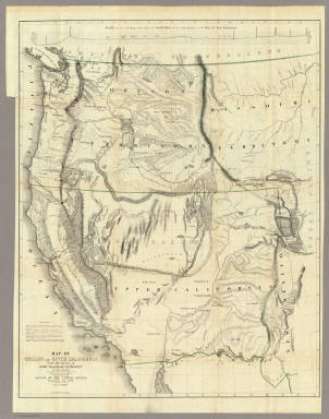
1848 Map Of Oregon And Upper California. Exploration Book Map Of Oregon And Upper California From … |

1846 Map Of The Road From Missouri To Oregon … Regional Atlas Topographical Map Of The Road From Misso … |

1867 California, Oregon & Nevada with Part of … National Atlas Schonberg's Map of California, Oregon & … |

1874 Oregon. National Atlas Asher & Adams' Oregon. Entered according … |

1956 Shell Highway Map of Oregon. National Atlas Shell Map of Oregon (cover title). Shell … |

1956 Various Regions and Cities in Oregon. National Atlas Crater Lake National Park. Mt. Hood Loop … |

1828 Cote NO, l'Amerique 2. Chart Atlas Cote nord-ouest de l'Amerique. Reconnue … |

1828 Cote NO, l'Amerique 3. Chart Atlas Cote nord-ouest de l'Amerique. Reconnue … |

1889 Covers: Oregon Pocket Map (Covers to) J.K. Gill & Cos. Map of Oreg … |

1889 Oregon Pocket Map J.K. Gill & Cos. Map of Oregon. Portland … |

1827 Partie des Etats Unis. Amer. Sep. 38. World Atlas Partie des Etats Unis. Amer. Sep. no. 38 … |

1925 Cover: Washington, Oregon auto trails. Pocket Map (Covers to) Rand McNally Official 1925 A … |

1925 Rand McNally Official 1925 Auto Trails M … Pocket Map Rand McNally Official 1925 Auto Trails M … |

1910 Covers: Oregon Pocket Map (Covers to) Oregon. Published by Geo. F. … |

1910 Title Page:Township and shippers' Guide … Pocket Map (Title Page to) Oregon. Published by Geo … |

1910 Oregon Pocket Map Oregon. Published by Geo. F. Cram, Chica … |

1889 Oregon. World Atlas Railroad and County Map of Oregon. Geo. … |

1886 Oregon, Washington and Idaho. World Atlas Colton's Oregon, Washington, and Idaho. … |

1874 Oregon, Washington, Idaho, Montana, Brit … World Atlas Colton's Oregon, Washington, Idaho, Mont … |

1866 Oregon, and Washington Territory. World Atlas Colton's Map of Oregon, Washington, Idah … |

1884 Covers: Oregon And Washington Pocket Map (Covers to) J.K. Gill & Cos. Map of Oreg … |

1884 Oregon And Washington Pocket Map J.K. Gill & Cos. Map of Oregon & Washing … |

1878 Covers: Oregon and Washington Pocket Map (Covers to) J.K. Gill & Cos. Map of Oreg … |

1878 Oregon and Washington Pocket Map J.K. Gill & Cos. Map of Oregon & Washing … |

1874 Covers: Map Of Oregon Pocket Map (Covers to) Habersham's Sectional and Co … |

1874 Map Of Oregon Pocket Map Habersham's Sectional and County Map Of … |

1909 Covers: Oregon Pocket Map (Covers to) Oregon. Rand, McNally & Co., … |

1909 Title Page: Oregon Pocket Map (Title Page to) Oregon. Rand, McNally & … |

1909 Oregon Pocket Map Oregon. Rand, McNally & Co., Map Publish … |

1901 Oregon. World Atlas Oregon. |

1890 Map Of Astoria And Environs, Oregon Separate Map Whitney's Map Of Astoria And Environs, O … |

1841 Map Of The Oregon Territory Separate Map Map Of The Oregon Territory By The U.S. … |

1853 California, Oregon, Utah, New Mexico World Atlas A new map of the State of California, th … |

1874 Map of Oregon, Washington, Idaho & Monta … National Atlas Map of Oregon, Washington, Idaho & Monta … |

1864 Washington, Oregon and Idaho World Atlas Johnson's Washington, Oregon and Idaho B … |

1855 California, Oregon, Washington, Utah and … World Atlas A new map of the state of California, th … |

1869 Western Coast Of The United States Chart Map U.S. Coast Survey A.D. Bache, Superinten … |

1860 Map Showing the Routes travelled by the … Separate Map Map Showing the Routes travelled by the … |

1851 A Diagram of a Portion of Oregon Territo … Separate Map A Diagram of a Portion of Oregon Territo … |