Who What Where WhenREMOVEWHO
|
Author
U.S. General Land Office
Full Title
Department Of The Interior General Land Office J.A. Williamson, Commissioner. State Of Oregon. 1879. Compiled from the official Records of the General Land Office and other sources by C. Roeser, Principal Draughtsman G.L.O. Photo lith & print by Julius Bien 16 & 18 Park Place N.Y.
Publisher
Julius Bien
Author
Colton, G.W.
Full Title
Washington And Oregon. Published By J.H. Colton & Co. No. 172 William St. New York. Entered ... 1853 by J.H. Colton & Co. ... New York. No. 53.
Publisher
J.H. Colton
Author
Duflot de Mofras, Eugene
Full Title
(Covers to) Exploration Du Territoire De L'Oregon, Des Californies Et De La Mer Vermeille, Executee Pendant Les Annees 1840, 1841 Et 1842, Par M. Duflot De Mofras, Attache A La Legation De France A Mexico. Ouvrage Publie Par Ordre Du Roi, Sous Les Auspices De M. Le Marechal Soult, Duc De Dalmatie, President du Conseil, Et De M. Le Ministre Des Affaires Etrangeres. Tome Premier. Paris, Arthus Bertrand, Editeur, Libraire De La Societe De Geographie, Rue Hautefeuille, No. 23. 1844. Paris. - Typographie de Firmin Didot Freres, rue Jacob, 56 ... Tome Second ... Atlas (with map) Carte De La Cote De L'Amerique Sur L'Ocean Pacifique Septentrional comprenant Le Territoire De L'Oregon, Les Californies, La Mer Vermeille ...
Publisher
Arthus Bertrand
Author
Duflot de Mofras, Eugene
Full Title
(Half Title Page to) Exploration Du Territoire De L'Oregon, Des Californies Et De La Mer Vermeille, Executee Pendant Les Annees 1840, 1841 Et 1842, Par M. Duflot De Mofras, Attache A La Legation De France A Mexico. Ouvrage Publie Par Ordre Du Roi, Sous Les Auspices De M. Le Marechal Soult, Duc De Dalmatie, President du Conseil, Et De M. Le Ministre Des Affaires Etrangeres. Tome Premier. Paris, Arthus Bertrand, Editeur, Libraire De La Societe De Geographie, Rue Hautefeuille, No. 23. 1844. Paris. - Typographie de Firmin Didot Freres, rue Jacob, 56 ... Tome Second ... Atlas (with map) Carte De La Cote De L'Amerique Sur L'Ocean Pacifique Septentrional comprenant Le Territoire De L'Oregon, Les Californies, La Mer Vermeille ...
Publisher
Arthus Bertrand
Author
Duflot de Mofras, Eugene
Full Title
(Title Page to) Exploration Du Territoire De L'Oregon, Des Californies Et De La Mer Vermeille, Executee Pendant Les Annees 1840, 1841 Et 1842, Par M. Duflot De Mofras, Attache A La Legation De France A Mexico. Ouvrage Publie Par Ordre Du Roi, Sous Les Auspices De M. Le Marechal Soult, Duc De Dalmatie, President du Conseil, Et De M. Le Ministre Des Affaires Etrangeres. Tome Premier. Paris, Arthus Bertrand, Editeur, Libraire De La Societe De Geographie, Rue Hautefeuille, No. 23. 1844. Paris. - Typographie de Firmin Didot Freres, rue Jacob, 56 ... Tome Second ... Atlas (with map) Carte De La Cote De L'Amerique Sur L'Ocean Pacifique Septentrional comprenant Le Territoire De L'Oregon, Les Californies, La Mer Vermeille ...
Publisher
Arthus Bertrand
Author
Duflot de Mofras, Eugene
Full Title
(Index to) Exploration Du Territoire De L'Oregon, Des Californies Et De La Mer Vermeille, Executee Pendant Les Annees 1840, 1841 Et 1842, Par M. Duflot De Mofras, Attache A La Legation De France A Mexico. Ouvrage Publie Par Ordre Du Roi, Sous Les Auspices De M. Le Marechal Soult, Duc De Dalmatie, President du Conseil, Et De M. Le Ministre Des Affaires Etrangeres. Tome Premier. Paris, Arthus Bertrand, Editeur, Libraire De La Societe De Geographie, Rue Hautefeuille, No. 23. 1844. Paris. - Typographie de Firmin Didot Freres, rue Jacob, 56 ... Tome Second ... Atlas (with map) Carte De La Cote De L'Amerique Sur L'Ocean Pacifique Septentrional comprenant Le Territoire De L'Oregon, Les Californies, La Mer Vermeille ...
Publisher
Arthus Bertrand
Author
Duflot de Mofras, Eugene
Full Title
Carte De La Cote De L'Amerique Sur L'Ocean Pacifique Septentrional Le Territoire De L'Oregon, Les Californies, La Mer Vermeille, Partie des Territoires de la Compagnie de la Baie d'Hudson, Et De L'Amerique Russe. Dressee par Mr. Duflot de Mofras, Attache a la Legation de France a Mexico; Pour servir a l'intelligence de son Voyage d'exploration Publie Par Ordre Du Roi, sous les Auspices De Mr. Le Marechal Duc De Dalmatie, Mr. Le Ministre Des Affaires Etrangeres. Paris, 1844. Le plan grave par Jacobs. L'ecriture gravee par Hacq. Publie par Arthus Bertrand.
Publisher
Arthus Bertrand
Author
Duflot de Mofras, Eugene
Full Title
Carte Du Rio Colombia Depuis Son Embouchure Jusqu' Au Fort Vancouver, a 17 Myriametres de la Mer. No. 18. Publie Par Arthus Bertrand. Voyage de Mr. Duflot de Mofras.
Publisher
Arthus Bertrand
Author
Fremont, J.C.
Full Title
(Title Page to) Report of The Exploring Expedition to The Rocky Mountains in the Year 1842, and to Oregon and North California in the Years 1843-'44.
Publisher
Blair and Rives
Author
Fremont, J.C.
Full Title
Map Of An Exploring Expedition To The Rocky Mountains in the Year 1842, Oregon & North California In The Years 1843-44. By Brevet Capt. J. C. Fremont Of The Corps Of Topographical Engineers Under the orders of Col. J.J. Abert, Chief Of The Topographical Bureau. Lith. by E. Weber & Co. Baltimore, Md.
Publisher
Blair and Rives
Author
Fremont, J.C.
Full Title
(Title Page to) Geographical Memoir upon Upper California In Illustration of His Map of Oregon and California, by John Charles Fremont: Addressed to the Senate of the United States. Washington: Wendell and Van Benthuysen, Printers. 1848. [Senate.] 30th Congress, 1st Session. Miscellaneous. No. 148.
Publisher
Wendell and Van Benthuysen
Author
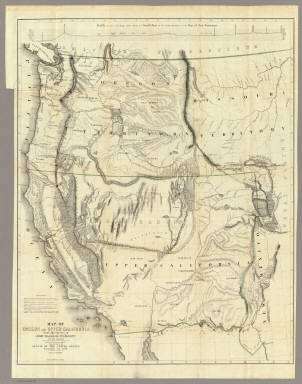
Fremont, J.C.
Full Title
Map Of Oregon And Upper California From the Surveys of John Charles Fremont And other Authorities. Drawn By Charles Preuss Under the Order of the Senate Of The United States, Washington City 1848. Lithy. by E. Weber & Co. Balto. (inset) Profile of the travelling route from the South Pass of the Rocky Mountains to the Bay of San Francisco.
Publisher
Wendell and Van Benthuysen
Author
[Fremont, J.C., Preuss, Charles]
Full Title
Topographical Map Of The Road From Missouri To Oregon, Commencing At The Mouth Of The Kansas In The Missouri River And Ending At The Mouth Of The Wallah Wallah In The Columbia. In VII Sections. Section VII. From the field notes and journal of Capt. J.C. Fremont, and from sketches and notes made on the ground by his assistant Charles Preuss. Compiled by Charles Preuss, 1846 By order of the Senate of the United States ... Lithogr. by E. Weber & Co. Baltimore ...
Publisher
U.S.
Author
Schonberg & Co.
Full Title
Schonberg's Map of California, Oregon & Nevada with Part of Idaho, Utah & Arizona. Entered ... 1866 .. New York.
Publisher
Schonberg & Co.
Author
Asher & Adams
Full Title
Asher & Adams' Oregon. Entered according to Act of Congress in the year 1874 by Asher & Adams ... at Washington. (New York, 1874)
Publisher
Asher and Adams
Author
Shell Oil Company
Full Title
Shell Map of Oregon (cover title). Shell Highway Map of Oregon. 6-DD-1956-1. (inset) Enlarged Map of Portland District.
Publisher
Shell Oil Company
Author
Shell Oil Company
Full Title
Crater Lake National Park. Mt. Hood Loop Highway. Eugene. Salem. (Verso to) Shell Highway Map of Oregon.
Publisher
Shell Oil Company
Author
Vancouver, George, 1757-1798
Full Title
Cote nord-ouest de l'Amerique. Reconnue par le Cape. Vancouver. 2e. partie, depuis 38015' de latitude septle. et 237027' de longitude jusqu'a 45046' de late. et 236015' de longe. (with) Baie de la Trinidad. Voyage de Vancouver. No. 5. (Paris: Depot-general de la Marine, 1828)
Publisher
Depot de la Marine
Author
Vancouver, George, 1757-1798
Full Title
Cote nord-ouest de l'Amerique. Reconnue par le Cape. Vancouver. 3e. partie, depuis 45030' de latitude septle. et 236012' de longitude, jusqu'a 52015' de late. et 232040' de longe. (with) Havre de Gray. (with) Port de la Decouverte. (with) Entree de la Riviere Columbia. Voyage de Vancouver. No. 6. (Paris: Depot-general de la Marine, 1828)
Publisher
Depot de la Marine
Author
[Gill, J.K., Galvani, W.H.]
Full Title
(Covers to) J.K. Gill & Cos. Map of Oregon. Portland Ogn. 1889. New Sectional Township & County Map Of Oregon. Published by J.K. Gill & Co. Booksellers and Stationers Portland, Oregon. Compiled and drawn from all United States and Railroad Surveys made previous to March 1st 1884 by W.H. Galvani, Civil Engineer, Portland Or. ... Entered ... 1889 by J.K. Gill & Co. ... Washington. Lith. by L.M. Snyder & Co. 79 Dearborn St. Chicago, Ill.
Publisher
J.K. Gill
Author
[Galvani, W.H., Gill, J.K.]
Full Title
J.K. Gill & Cos. Map of Oregon. Portland Ogn. 1889. New Sectional Township & County Map Of Oregon. Published by J.K. Gill & Co. Booksellers and Stationers Portland, Oregon. Compiled and drawn from all United States and Railroad Surveys made previous to March 1st 1884 by W.H. Galvani, Civil Engineer, Portland Or. ... Entered ... 1889 by J.K. Gill & Co. ... Washington. Lith. by L.M. Snyder & Co. 79 Dearborn St. Chicago, Ill.
Publisher
J.K. Gill
Author
Vandermaelen, Philippe, 1795-1869
Full Title
Partie des Etats Unis. Amer. Sep. no. 38. (Dresse par Ph. Vandermaelen, lithographie par H. Ode. Quatrieme partie. - Amer. sept. Bruxelles. 1827)
Publisher
Ph. Vandermaelen
Author
Rand McNally and Company
Full Title
(Covers to) Rand McNally Official 1925 Auto Trails Map Washington Oregon. Copyright by Rand McNally & Company Chicago, Ill. Made in U.S.A. (on verso) Rand McNally Official 1925 Auto Trails Map British Colombia. Copyright by Rand McNally & Company Chicago, Ill. Made in U.S.A.
Publisher
Rand McNally
Author
Rand McNally and Company
Full Title
Rand McNally Official 1925 Auto Trails Map Washington Oregon. Copyright by Rand McNally & Company Chicago, Ill. Made in U.S.A.
Publisher
Rand McNally
Author
Cram, George Franklin
Full Title
(Covers to) Oregon. Published by Geo. F. Cram, Chicago, Ill. George F. Cram, Engraver & Publisher, Chicago, Ill.
Publisher
George F. Cram
Author
Cram, George Franklin
Full Title
(Title Page to) Oregon. Published by Geo. F. Cram, Chicago, Ill. George F. Cram, Engraver & Publisher, Chicago, Ill.
Publisher
George F. Cram
Author
Cram, George Franklin
Full Title
Oregon. Published by Geo. F. Cram, Chicago, Ill. George F. Cram, Engraver & Publisher, Chicago, Ill.
Publisher
George F. Cram
Author
Cram, George Franklin
Full Title
Railroad and County Map of Oregon. Geo. F. Cram. Engraver and Publisher, Chicago.
Publisher
George F. Cram
Author
Colton, G.W.
Full Title
Colton's Oregon, Washington, and Idaho. Published By G. W & C. B. Colton & Co., No. 182 William St. New York.
Publisher
G. W & C. B. Colton & Co.
Author
Colton, G.W.
Full Title
Colton's Oregon, Washington, Idaho, Montana, and British Columbia. Published By G. W & C. B. Colton & Co., No. 172 William St. New York.
Publisher
G. W & C. B. Colton & Co.
Author
Colton, G.W.
Full Title
Colton's Map of Oregon, Washington, Idaho, British Columbia & Montana. Published by G.W. & C.B. Colton & Co., No. 172 William St. New York.
Publisher
G.W. & C.B. Colton
Author
[Gill, J.K., Galvani, W.H.]
Full Title
(Covers to) J.K. Gill & Cos. Map of Oregon & Washington. Portland Ogn. 1884. New Sectional Township & County Map Of Oregon & Washington. Published by J.K. Gill & Co. Booksellers & Stationers, Portland Oregon. Compiled and drawn from all United States and Railroad Surveys made previous to March 1st 1884 by W.H. Galvani, Civil Engineer, Portland Or. ... Entered ... 1884 by J.K. Gill & Co. ... Washington. Lith. by L.M. Snyder & Co. 79 Dearborn St. Chicago, Ill.
Publisher
J.K. Gill & Co.
Author
[Gill, J.K., Galvani, W.H.]
Full Title
J.K. Gill & Cos. Map of Oregon & Washington. Portland Ogn. 1884. New Sectional Township & County Map Of Oregon & Washington. Published by J.K. Gill & Co. Booksellers & Stationers, Portland Oregon. Compiled and drawn from all United States and Railroad Surveys made previous to March 1st 1884 by W.H. Galvani, Civil Engineer, Portland Or. ... Entered ... 1884 by J.K. Gill & Co. ... Washington. Lith. by L.M. Snyder & Co. 79 Dearborn St. Chicago, Ill.
Publisher
J.K. Gill & Co.
Author
[Gill, J.K., Habersham, Robert A.]
Full Title
(Covers to) J.K. Gill & Cos. Map of Oregon & Washington Ter. Portland Ogn. 1878. Showing all surveys made previous to January 1st 1878. Compiled by Robt. A. Habersham, Civil Engineer. Entered ... 1878 by J.K. Gill & Co. ... Washington. Lith. by A.M. Askevold, Ashland Block, Chicago.
Publisher
J.K. Gill & Co.
Author
[Gill, J.K., Habersham, Robert A.]
Full Title
J.K. Gill & Cos. Map of Oregon & Washington Ter. Portland Ogn. 1878. Showing all surveys made previous to January 1st 1878. Compiled by Robt. A. Habersham, Civil Engineer. Entered ... 1878 by J.K. Gill & Co. ... Washington. Lith. by A.M. Askevold, Ashland Block, Chicago.
Publisher
J.K. Gill & Co.
Author
[Gill, J.K., Habersham, Robert A., Colton, G.W. & C.B.]
Full Title
(Covers to) Habersham's Sectional and County Map Of Oregon. Compiled from the most recent U.S. Government Maps & Surveys. Published by J.K. Gill & Co. Booksellers And Engravers Portland, Ogn. 1874. Engraved & Printed by G.W. & C.B. Colton & Co. New York. Entered ... 1874 by Robt. A. Habersham ... Washington.
Publisher
J.K. Gill & Co.
Author
[Gill, J.K., Habersham, Robert A., Colton, G.W. & C.B.]
Full Title
Habersham's Sectional and County Map Of Oregon. Compiled from the most recent U.S. Government Maps & Surveys. Published by J.K. Gill & Co. Booksellers And Engravers Portland, Ogn. 1874. Engraved & Printed by G.W. & C.B. Colton & Co. New York. Entered ... 1874 by Robt. A. Habersham ... Washington.
Publisher
J.K. Gill & Co.
Author
Rand McNally and Company
Full Title
(Covers to) Oregon. Rand, McNally & Co., Map Publishers and Engravers, Chicago, 1909. Rand, McNally & Co.'s New Business Atlas Map of Oregon. Copyright, 1909, ... 1906 ... (with 25 page index) Rand McNally & Co.'s Indexed County And Railroad Pocket Map And Shippers' Guide Of Oregon ... Chicago And New York: Rand, McNally & Co. ... (on verso) Copyright, 1909, Rand, McNally & Co., Chicago.
Publisher
Rand McNally & Co.
Author
Rand McNally and Company
Full Title
(Title Page to) Oregon. Rand, McNally & Co., Map Publishers and Engravers, Chicago, 1909. Rand, McNally & Co.'s New Business Atlas Map of Oregon. Copyright, 1909, ... 1906 ... (with 25 page index) Rand McNally & Co.'s Indexed County And Railroad Pocket Map And Shippers' Guide Of Oregon ... Chicago And New York: Rand, McNally & Co. ... (on verso) Copyright, 1909, Rand, McNally & Co., Chicago.
Publisher
Rand McNally & Co.
Author
Rand McNally and Company
Full Title
Oregon. Rand, McNally & Co., Map Publishers and Engravers, Chicago, 1909. Rand, McNally & Co.'s New Business Atlas Map of Oregon. Copyright, 1909, ... 1906 ... (with 25 page index) Rand McNally & Co.'s Indexed County And Railroad Pocket Map And Shippers' Guide Of Oregon ... Chicago And New York: Rand, McNally & Co. ... (on verso) Copyright, 1909, Rand, McNally & Co., Chicago.
Publisher
Rand McNally & Co.
Author
Cram, George Franklin
Full Title
Oregon.
Publisher
George F. Cram
Author
[Whitney, W.H., Jackson, Henry & Co.]
Full Title
Whitney's Map Of Astoria And Environs, Oregon. Compiled from Official Data, By Henry Jackson & Co., Civil Engineers. March 1st, 1890. Compliments Of Wingate & Stone ... Astoria, Oregon. Union Pacific. The Overland Route. L.H. Everts, Lith. Phila. Pa. Entered ... 1890, by W.H. Whitney ... Washington. (untitled inset map of mouth of the Columbia River).
Publisher
L.H. Everts, Lith.
Author
Wilkes, Charles
Full Title
Map Of The Oregon Territory By The U.S. Ex. Ex. Charles Wilkes Esqr. Commander. 1841. Note. The Northern part of this Map contains the latest information of the Hudson Bay Company, and the Eastern part, that of Lieut. Fremont's U.S.T.E. Exploration on the Eastern side of the Rocky Mountains. (inset map) Columbia River Reduced From A Survey Made By The U.S. Ex. Ex. 1841.
Publisher
No publisher
Author
Mitchell, Samuel Augustus
Full Title
A new map of the State of California, the Territories of Oregon & Utah, and the Chief part of New Mexico. Entered ... 1853, by Thomas, Cowperthwait & Co. ... Pennsylvania.
Publisher
Thomas, Cowperthwait & Co.
Author
Mitchell, Samuel Augustus Jr.
Full Title
Map of Oregon, Washington, Idaho & Montana. Entered ... 1874 by S. Augustus Mitchell ... Washington.
Publisher
Ziegler & McCurdy
Author
Johnson, A.J.
Full Title
Johnson's Washington, Oregon and Idaho By Johnson and Ward.
Publisher
Johnson and Ward
Author
Mitchell, Samuel Augustus
Full Title
A new map of the state of California, the territories of Oregon, Washington, Utah and New Mexico. Published by Thomas, Cowperthwait & Co., no. 253 Market Street, Philadelphia. Entered ... 1853 by Thomas, Cowperthwait & Co. ... Pennsylvania.
Publisher
Cowperthwait, Desilver & Butler
Author
U.S. Coast Survey
Full Title
U.S. Coast Survey A.D. Bache, Superintendent Reconnaissance Of The Western Coast Of The United States, Middle Sheet, From San Francisco To Umpquah River. By the Hydrographic Party under the command of Lieut. James Alden U.S.N. Assist. Geographical Positions by G. Davidson Assistant. 1854. Corrected to 1869. Drawn by W.B. McMurtrie; Reduction for engraving by A. Lindenkohl. Engd. by G. McCoy, J. Knight, J.L Hazzard & G.B. Metzeroth. No. 602. Electrotype Copy No. 6 by G. Mathiot U.S.C.S.
Publisher
U.S. Coast Survey
Author
[Steen, E., Dixon, Joseph]
Full Title
Map Showing the Routes travelled by the Command Of Majr. E. Steen, U.S. Drags. against the Snake Indians in 1860 by Lieut. Joseph Dixon, U.S. Topl. Engrs. from explorations and surveys made by him while attached to this Command. Drawn under the direction of Capt. G. Thom U.S. Topl. Engrs. Lith. of J. Bien 180 Broadway New York.
Publisher
U.S.
Author
U.S. General Land Office
Full Title
A Diagram of a Portion of Oregon Territory. Surveyor General's Office, Oregon City, October 20th., 1851. John B. Preston, Surveyor General. D. McClelland Sc. Washn. D.C. (to accompany ten issues of) A Diagram of Oregon (1851,52,55,58,59,60,61,63,64).
Publisher
J. Bien
|