Browse All

1837 Karte vom Grossen Ocean, (Mare Pacifico) … World Atlas Karte vom Grossen Ocean, (Mare Pacifico) … |

1840 Der Warme Meeresstrom Des Atlantischen. World Atlas Der Warme Meeresstrom Des Atlantischen u … |

1838 Karte von dem Vulkan Gurtel. World Atlas Karte von dem Vulkan Gurtel und dem Cent … |

1846 Ethnographische Karte von Afrika. World Atlas Ethnographische Karte von Afrika von HBg … |

1856 Hawaiian Group Or Sandwich Islands ... N … World Atlas Hawaiian Group Or Sandwich Islands (with … |

1844 Carte De L'Ocean Pacifique Au Nord De L' … Exploration Book Carte De L'Ocean Pacifique Au Nord De L' … |

1776 Chart containing the Coasts of Californi … National Atlas Chart containing the Coasts of Californi … |

1776 Chart containing the greater part of the … National Atlas Chart containing the greater part of the … |

1776 Composite: North & South America. National Atlas (Composite of) A Chart of North and Sout … |

1828 Cover: Neptune, cotes occident. d'Ameriq … Chart Atlas (Covers to) Neptune des cotes occidental … |

1828 Title Page: Neptune, cotes occident. d'A … Chart Atlas (Title Page to) Neptune des cotes occide … |

1828 Contents: Neptune, cotes occident. d'Ame … Chart Atlas (Contents to) Neptune des cotes occident … |

1818 Grand Ocean. Chart Atlas Carte reduite du Grand Ocean compris ent … |
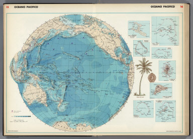
1952 Oceano Pacifico. World Atlas Oceano Pacifico. (insets) Isola Christma … |

1952 Australia, Oceania. World Atlas Australia, Oceania. (insets) Nuova Caled … |

1889 Islands in the Pacific Ocean. World Atlas Islands in the Pacific Ocean. |

1840 Pacific Ocean. World Atlas The Pacific Ocean. Published under the s … |

1840 Polynesia. World Atlas Polynesia or islands in the Pacific Ocea … |

1861 Oceania. World Atlas Oceania by Keith Johnston, F.R.S.E. (wit … |

1901 Islands in the Pacific Ocean. World Atlas Islands in the Pacific Ocean. |

1901 Map of the Pacific Ocean (Showing Distan … World Atlas Map of the Pacific Ocean (Showing Distan … |

1853 Pacific Ocean Including Oceanica World Atlas The Pacific Ocean Including Oceanica, wi … |

1958 The Orient, Plate 9, v.1 World Atlas The Orient. 1:55,000,000. Transverse Mer … |

1944 Pacific Arena World Atlas Pacific Arena. Orthographic Projection. … |

1862 Oceanie spheroidale. World Atlas Oceanie spheroidale. Atlas spheroidal & … |

1855 Pacific Ocean Including Oceanica World Atlas The Pacific Ocean Including Oceanica wit … |

1862 Oceanie. World Atlas Oceanie. Atlas spheroidal & universel de … |

1862 L'Oceanie, divers archipels. World Atlas Les divers archipels de l'Oceanie. (with … |

1953 Pacific Islands and Australia. World Atlas Pacific Islands and Australia. (insets) … |

1953 Pacific Ocean. World Atlas Pacific Ocean. |

1828 Pacific Ocean. World Atlas Pacific Ocean. By Sidney Hall. London, p … |

1845 Oceanica And The Pacific Ocean School Atlas Oceanica And The Pacific Ocean. Adapted … |

1846 Australien. World Atlas Neueste Karte von Australien. Nach den b … |

1798 Cover: Voyage of discovery to the North … Chart Atlas (Covers to) A Voyage Of Discovery To The … |

1798 Title Page: Voyage of discovery to the N … Chart Atlas (Title Page to) A Voyage Of Discovery To … |

1798 Index: Voyage of discovery to the North … Chart Atlas (Index to) A Voyage Of Discovery To The … |

1798 The S.W. Coast of New Holland. Chart Atlas A Chart Shewing part of the S.W. Coast o … |

1798 Views of Parts of the South West Coast o … Chart Atlas Views of Parts of the South West Coast o … |

1841 Carta generale dell'Oceania. World Atlas Carta generale dell'Oceania. Questa cart … |

1824 Hemisphaere des Stillen Oceans. [School Atlas, World Atlas] Hemisphaere des Stillen Oceans. Berlin 1 … |

1799 Terebartulae, or Anomle of Linnaeus. Exploration Book Terebartulae, or Anomle of Linnaeus. Cor … |

1799 Massacre of De Langle, Lemanon & Ten Oth … Exploration Book Massacre of De Langle, Lemanon & Ten Oth … |

1799 Pacific Ocean between California and the … Exploration Book (Two charts on one sheet). Part of the P … |

1799 Chart of the Great Pacific Ocean. Exploration Book Chart of the Great Pacific Ocean or Sout … |

1799 Route of the Spanish frigate la Princesa … Exploration Book Part of the Great Pacific Ocean showing … |

1848 Oceana Or Pacific Ocean. World Atlas Oceana or Pacific Ocean. 70. (1848) |

1901 Hawaii, U.S. possessions Pacific Ocean. Pocket Map Map of territory of Hawaii. Published by … |

1901 Cover: Alaska, Hawaii. Pocket Map (Covers to) Alaska. Published by Geo. F. … |

1856 Oceanie. National Atlas Oceanie. Atlas Universel Illustre. Grave … |

1922 Islands of Oceania. World Atlas Islands of Oceania on uniform scale. The … |