Browse All

1881 Grosser Ocean. World Atlas Grosser Ocean, Meerestiefen und Telegrap … |

1821 E. Asia, W. North America. World Atlas A map of the discoveries made by Capts. … |

1870 Oceanica, Sandwich Islands. [State Atlas, World Atlas] Map of Oceanica, exhibiting its various … |

1890 Oceanica, Sandwich Islands. World Atlas Map of Oceanica, exhibiting its various … |

1852 Australien. School Atlas Australien. (Efter Stielers Hand-Atlas. … |

1835 Polynesia. World Atlas Polynesia. Fenner Sc., Paternoster Row. … |

1850 Australien und Polynesien (Australia and … World Atlas No. LXII. Stieler's Hand-Atlas (No. 50a) … |

1849 West-Polynesien. (Western Polynesia). World Atlas Stieler's Hand-Atlas (No. 51). West-Poly … |

1849 Ost-Polynesien. (Eastern Polynesia). World Atlas Stieler's Hand-Atlas (No. 52). Ost-Polyn … |

1852 Australien und Polynesien in Mercators P … World Atlas No. LXII. Stieler's Hand-Atlas (No. 50a) … |

1852 West-Polynesien. (Western Polynesia). World Atlas Stieler's Hand-Atlas (No. 51). West-Poly … |

1849 Ost-Polynesien. (Eastern Polynesia). World Atlas Stieler's Hand-Atlas (No. 52). Ost-Polyn … |

1853 Advertisement - back liner: Atlanten im … World Atlas (Advertisement - back liner). Atlanten i … |

1795 Map of the Discoveries made by Capts. Co … World Atlas A Map of the Discoveries made by Capts. … |

1796 Map of the Discoveries made by Capts. Co … World Atlas A Map of the Discoveries made by Capts. … |

1836 A New Chart of The Pacific Ocean (Northe … Chart Map A New Chart of The Pacific Ocean, Exhibi … |

1836 A New Chart of The Pacific Ocean (Southe … Chart Map A New Chart of The Pacific Ocean, Exhibi … |

1836 Composite: A New Chart of The Pacific Oc … Chart Map (Composite of) A New Chart of The Pacifi … |

1875 Polynesien Und Der Grosse Ocean (Westlic … World Atlas Polynesien Und Der Grosse Ocean Im Maass … |

1875 Polynesien Und Der Grosse Ocean (Ostlich … World Atlas Polynesien Und Der Grosse Ocean Im Maass … |

1859 Pacific Ocean including Oceania. World Atlas The Pacific Ocean including Oceania with … |

1944 Pacific Front. 20. Preface to Pearl Harb … World Atlas Pacific Front. 20. Preface to Pearl Harb … |

1944 Pacific Front. (Continues) 21. Amphibiou … World Atlas Pacific Front. 21. Amphibious Blitzkrieg |

1944 Pacific Front. 21. Amphibious Blitzkrieg … World Atlas Pacific Front. 21. Amphibious Blitzkrieg |

1944 Pacific Front.(Continues) 22. Holding th … World Atlas Pacific Front. 22. Holding the Pacific F … |

1944 Pacific Front. 22. Holding the Pacific F … World Atlas Pacific Front. 22. Holding the Pacific F … |

1944 Pacific Front. 23. American Counteroffen … World Atlas Pacific Front. 23. American Counteroffen … |

1944 Pacific Front. 23. American Counteroffen … World Atlas Pacific Front. 23. American Counteroffen … |

1944 Pacific Front. 23. American Counteroffen … World Atlas Pacific Front. 23. American Counteroffen … |

1944 Pacific Front. 23. American Counteroffen … World Atlas Pacific Front. 23. American Counteroffen … |

1944 Supply Lines to Victory. 26. Battle of t … World Atlas Supply Lines to Victory. 26. Battle of t … |

1875 Composite: Polynesien, Grosse Ocean. World Atlas (Composite of) Polynesien und der Grosse … |

1958 The Pacific World Atlas The Pacific. (Copyright) G.P. Ltd. (with … |

1856 Pacific Ocean. Physical Atlas Physical chart of the Pacific Ocean or G … |

1856 Zoological geography. Physical Atlas Zoological geography. Geographical divis … |

1856 Australien. World Atlas Australien. (with New South Wales). (wit … |

1849 Chart of the North Pacific Ocean. Chart Map Chart of the North Pacific Ocean, Exhibi … |

1860 Ost-Polynesien. (Eastern Polynesia). World Atlas Stieler's Hand-Atlas ... No. 52. Ost-Pol … |

1872 Polynesien und Der Grosse Ocean. (Wester … World Atlas Stieler's Hand-Atlas ... No. 76. Polynes … |

1872 Polynesien und Der Grosse Ocean. (Easter … World Atlas Stieler's Hand-Atlas ... No. 77. Polynes … |

1816 Australien, 1816 World Atlas Australien: Nach Mercators Projection, e … |

1879 Polynesien und Der Grosse Ocean (Westlic … World Atlas Stieler's Hand-Atlas No. 76. Polynesien … |

1879 Polynesien und Der Grosse Ocean (Ostlich … World Atlas Stieler's Hand-Atlas No. 77. Polynesien … |

1840 Chart of the Viti Group or Feejee Island … Exploration Book Chart of the Viti Group or Feejee Island … |

1968 Indian and Pacific Oceans Physical. [School Atlas, World Atlas] Indian and Pacific Oceans Physical. |
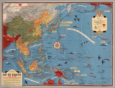
1944 Dated Events. On To Tokyo. Map of the Pa … Separate Map Dated Events. On To Tokyo. Map of the Pa … |

1835 Australien nach Krusenstern u.A. in Merc … World Atlas No. LXII. Stieler's Hand-Atlas (No. 50). … |

1969 Eastern Murray Fracture Zone and Transve … Geologic Atlas Eastern Murray Fracture Zone and Transve … |

1979 Oblique Map of the Northern California C … Geologic Atlas Oblique Map of the Northern California C … |

1970 Southern California Borderland. Geologic Atlas Southern California Borderland. |