Who What Where WhenREMOVEWHO
|
Full Title
Grosser Ocean, Meerestiefen und Telegraphenkabel. (with) Tahiti und Moorea. (with) Tonga, Freundschafts In. (with) Tongatabu. (with) Markesas Inseln. (with) Nukuhiva. (with) Hivaoa und Tahuata. (Richard Andree. Herausgegeben von der Geographischen Anstalt von Velhagen & Klasing in Leipzig. 1881)
Publisher
Velhagen & Klasing
Author
Seaman, James V.
Full Title
A map of the discoveries made by Capts. Cook & Clerke in the years 1778 & 1779 between the eastern coast of Asia and the western coast of North America when they attempted to navigate the North Sea, also Mr. Hearn's discoveries to the north westward of Hudson's Bay. Published by J.V. Seaman, 296 Pearl St., N. York. (1821)
Publisher
James V. Seaman
Author
Mitchell, Samuel Augustus
Full Title
Map of Oceanica, exhibiting its various divisions, island groups &c. (with) Map of the Sandwich Islands. Entered ... 1867 by S. Augustus Mitchell, Jr. ... Pennsylvania. (1870)
Publisher
[R.A. Campbell, S.A. Mitchell, Jr.]
Full Title
Map of Oceanica, exhibiting its various divisions, island groups &c. (with) Map of the Sandwich Islands. Copyright 1887 by Wm. M. Bradley & Bro. (1890)
Publisher
John Y. Huber & Co.
Full Title
Australien. (Efter Stielers Hand-Atlas. Stockholm, J.L. Brudin, 1852)
Publisher
J.L. Brudin
Author
Fenner, Rest.
Full Title
Polynesia. Fenner Sc., Paternoster Row. (London, Joseph Thomas, 1835)
Publisher
Joseph Thomas
Author
[Stieler, Adolf, Stulpnagel, F.v.]
Full Title
No. LXII. Stieler's Hand-Atlas (No. 50a). Australien und Polynesien in Mercators Projection
Publisher
Justus Perthes
Author
[Stieler, Adolf, Berghaus, H.]
Full Title
Stieler's Hand-Atlas (No. 51). West-Polynesien.
Publisher
Justus Perthes
Author
[Stieler, Adolf, Berghaus, H.]
Full Title
Stieler's Hand-Atlas (No. 52). Ost-Polynesien.
Publisher
Justus Perthes
Author
[Stieler, Adolf, Stulpnagel, F.v.]
Full Title
No. LXII. Stieler's Hand-Atlas (No. 50a). Australien und Polynesien in Mercators Projection.
Publisher
Justus Perthes
Author
[Stieler, Adolf, Berghaus, H.]
Full Title
Stieler's Hand-Atlas (No. 51). West-Polynesien.
Publisher
Justus Perthes
Author
Stieler, Adolf
Full Title
Stieler's Hand-Atlas (No. 52). Ost-Polynesien.
Publisher
Justus Perthes
Author
Stieler, Adolf
Full Title
(Advertisement - back liner). Atlanten im Verlag von Justus Perthus in Gotha.
Publisher
Justus Perthes
Author
Carey, Mathew
Full Title
A Map of the Discoveries made by Capts. Cook & Clerke in the Years 1778 & 1779 between the Eastern Coast of Asia and the Western Coast of North America when they attempted to Navigate the North Sea. Also Mr. Hearn's discoveries to the North westward of Hudson's Bay, in 1772. J.T. Scott sculp. Engraved for Carey's American Edition of Guthrie's Geography improved.
Publisher
Mathew Carey
Author
Norie, J.W.
Full Title
A New Chart of The Pacific Ocean, Exhibiting The Western Coast of America, From Cape Horn To Beerings Strait, The Eastern Shores of Asia Including Japan, China and Australia, and all the numerous Islands and known Dangers Situated in Polynesia and Australasia, Correctly Drawn And Regulated according to the most Approved and Modern Surveys and Astronomical Observations By J.W. Norie, Hydrographer, &c.&c. Additions 1836. Stephenson, Engraver. London. Published ... October 1st 1825, by J.W. Norie & Co. (with) seven inset maps listed in Notes. (Northern Sheet)
Publisher
J.W. Norie & Co.
Author
Norie, J.W.
Full Title
A New Chart of The Pacific Ocean, Exhibiting The Western Coast of America, From Cape Horn To Beerings Strait, The Eastern Shores of Asia Including Japan, China and Australia, and all the numerous Islands and known Dangers Situated in Polynesia and Australasia, Correctly Drawn And Regulated according to the most Approved and Modern Surveys and Astronomical Observations By J.W. Norie, Hydrographer, &c.&c. Additions 1836. Stephenson, Engraver. London. Published ... October 1st 1825, by J.W. Norie & Co. (with) seven inset maps listed in Notes. (Southern Sheet)
Publisher
J.W. Norie & Co.
Author
Norie, J.W.
Full Title
(Composite of) A New Chart of The Pacific Ocean, Exhibiting The Western Coast of America, From Cape Horn To Beerings Strait, The Eastern Shores of Asia Including Japan, China and Australia, and all the numerous Islands and known Dangers Situated in Polynesia and Australasia, Correctly Drawn And Regulated according to the most Approved and Modern Surveys and Astronomical Observations By J.W. Norie, Hydrographer, &c.&c. Additions 1836. Stephenson, Engraver. London. Published ... October 1st 1825, by J.W. Norie & Co. (with) seven inset maps listed in Notes. (Northern and Southern Sheets)
Publisher
J.W. Norie & Co.
Author
Stieler, Adolf
Full Title
Polynesien Und Der Grosse Ocean Im Maassstabe von 1:40.000.000. (Westliches Blatt) Von A. Petermann. Gezeichnet v. E. Debes. Gest v. Stier & Jungmann. Gotha: Justus Perthes 1872.
Publisher
Justus Perthes
Author
Stieler, Adolf
Full Title
Polynesien Und Der Grosse Ocean Im Maassstabe von 1:40.000.000. (Ostliches Blatt) Von A. Petermann. Gezeichnet v. E. Debes. Gest v. C. Stier. Gotha: Justus Perthes 1872.
Publisher
Justus Perthes
Author
Mitchell, Samuel Augustus
Full Title
The Pacific Ocean including Oceania with its several Divisions, Islands, Groups, &c. 75. Entered according to Act of Congress in the year 1859 by Charles Desilver in the Clerk's office if the District Court of the Eastern District of Pennsylvania.
Publisher
Charles Desilver.
Author
U.S. Office of War Information
Full Title
Pacific Front. 20. Preface to Pearl Harbor.
Publisher
Simon and Schuster
Author
U.S. Office of War Information
Full Title
Pacific Front. 21. Amphibious Blitzkrieg
Publisher
Simon and Schuster
Author
U.S. Office of War Information
Full Title
Pacific Front. 21. Amphibious Blitzkrieg
Publisher
Simon and Schuster
Author
U.S. Office of War Information
Full Title
Pacific Front. 22. Holding the Pacific Front.
Publisher
Simon and Schuster
Author
U.S. Office of War Information
Full Title
Pacific Front. 22. Holding the Pacific Front.
Publisher
Simon and Schuster
Author
U.S. Office of War Information
Full Title
Pacific Front. 23. American Counteroffensive in the Pacific.
Publisher
Simon and Schuster
Author
U.S. Office of War Information
Full Title
Pacific Front. 23. American Counteroffensive in the Pacific.
Publisher
Simon and Schuster
Author
U.S. Office of War Information
Full Title
Pacific Front. 23. American Counteroffensive in the Pacific.
Publisher
Simon and Schuster
Author
U.S. Office of War Information
Full Title
Pacific Front. 23. American Counteroffensive in the Pacific.
Publisher
Simon and Schuster
Author
U.S. Office of War Information
Full Title
Supply Lines to Victory. 26. Battle of the Pacific
Publisher
Simon and Schuster
Author
Stieler, Adolf
Full Title
(Composite of) Polynesien und der Grosse Ocean im Maassstabe von 1:40.000.000. Von A. Petermann. Gezeichnet v. E. Debes. Gest v. Stier & Jungmann. Gotha: Justus Perthes 1872.
Publisher
Justus Perthes
Author
Debenham, Frank
Full Title
The Pacific. (Copyright) G.P. Ltd. (with inset map) Lonely Volcanic and coral islands rising as mountains from the depths of the vast Pacific Ocean.
Publisher
Simon and Schuster
Author
Johnston, Alexander Keith, 1804-1871
Full Title
Physical chart of the Pacific Ocean or Great Sea, Mare Pacifico. Showing the currents & temperature of the ocean, the trade routes &c. Founded on the observations which have been made from the time of Magalhaen to the Prussian navigators. With additions & corrections to 1855. By A.K. Johnston, F.R.S.E. Engraved by W. & A.K. Johnston. William Blackwood & Sons, Edinburgh & London. (1856)
Publisher
William Blackwood & Sons
Author
Johnston, Alexander Keith, 1804-1871
Full Title
Zoological geography. Geographical division & distribution of Simiae & Prosimiae, monkeys & makis, from the latest authorities by A.K. Johnston, F.R.S.E. Geographical division & distribution of Pachydermata, thick skinned animals ... Engraved by W. & A.K. Johnston. William Blackwood & Sons, Edinburgh & London. (1856)
Publisher
William Blackwood & Sons
Author
[Geographisches Institut (Weimar, Germany), Kiepert, Heinrich, 1818-1899]
Full Title
Australien. (with New South Wales). (with) Tasmania oder Van-Diemens Land. (with) Neu Seeland, New-Zealand. (with) Hawaii Archipelagus, Sandwich-Inseln. (with) Taheiti Archipelagus, Societats Inseln. Gezeichnet v. H. Kiepert. Gest. v. C. Kratz. Weimar, geographisches Institut, 1856.
Publisher
Weimar Geo Inst.
Author
Imray, James.
Full Title
Chart of the North Pacific Ocean, Exhibiting the Eastern Shores of Asia and the Western Coast of North America from the Equator to Behring's Strait with Plans, on an Enlarged Scale, of the Principal Islands and Harbours. Compiled from the most Recent Surveys made by order of the British, French, and United States Governments. London. Published by James Imray. Chart and Nautical Bookseller, 102 Minores, 1849. (insets) Sandwich Islands (Hawaii); Philippine Islands; Harbor of San Francisco; Victoria Harbor; Mouth of the Columbia River; Marian or Ladrone Islands; Awatska Harbor in Kamchatka.
Publisher
James Imray
Author
[Stieler, Adolf, Berghaus]
Full Title
Stieler's Hand-Atlas ... No. 52. Ost-Polynesien. (insets) Hawaii Vulkane. Floriana. Honolulu. Tahiti.
Publisher
Justus Perthes
Author
[Stieler, Adolf, Petermann, A.]
Full Title
Stieler's Hand-Atlas ... No. 76. Polynesien und Der Grosse Ocean (Westliches Blatt). (insets) Various Pacific slands.
Publisher
Justus Perthes
Author
[Petermann, A., Stieler, Adolf]
Full Title
Stieler's Hand-Atlas ... No. 77. Polynesien und Der Grosse Ocean (Ostliches Blatt). (insets) Various Pacific Islands.
Publisher
Justus Perthes
Author
Stieler, Adolf
Full Title
Australien: Nach Mercators Projection, entw. u. gez.v. C.G. Reichard. 1816. Gest. v. L. Hess.(on upper right margin) Hand-Atlas No. 50. (to accompany) Hand-Atlas uber alle Theile der Erde, nach dem neuesten Zustande und uber das Weltgebaude.
Publisher
Justus Perthes
Author
[Stieler, Adolf, Petermann, A.]
Full Title
Stieler's Hand-Atlas No. 76. Polynesien und Der Grosse Ocean (Westliches Blatt). (insets) Various Pacific Islands.
Publisher
Justus Perthus
Author
[Stieler, Adolf, Petermann, A.]
Full Title
Stieler's Hand-Atlas No. 77. Polynesien und Der Grosse Ocean (Ostliches Blatt). (insets) Various Pacific Islands.
Publisher
Justus Perthus
Author
[United States Exploring Expedition (1838-1842), Wilkes, Charles, 1798-1877]
Full Title
Chart of the Viti Group or Feejee Islands by the U.S. Ex. Ex. Charles Wilkes Esq. Commander. 1840. Eng. by Sherman & Smith, N.Y.
Publisher
Lea & Blanchard
Author
McGraw-Hill Book Company
Full Title
Indian and Pacific Oceans Physical.
Publisher
General Drafting Co., Inc.
Author
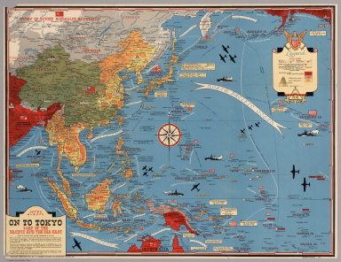
[Turner, Stanley, Petersen, C.C.]
Full Title
Dated Events. On To Tokyo. Map of the Pacific and the Far East. Stanley Turner, 44. Copyright, Canada and U.S.A., 1944, C.C. Petersen, Publishing and Advertising, Toronto, Canada. Seventh Edition.
Publisher
C.C. Petersen Publishing and Advertising
Author
Stieler, Adolf
Full Title
No. LXII. Stieler's Hand-Atlas (No. 50). Australien nach Krusenstern u.A. in Mercators Projection.
Publisher
Justus Perthus
Author
[U.S. Geological Survey, Alpha, Tau Rho]
Full Title
Eastern Murray Fracture Zone and Transverse Ranges.
Publisher
U.S. Geological Survey
Author
[U.S. Geological Survey, Alpha, Tau Rho, Gerin, Marybeth]
Full Title
Oblique Map of the Northern California Continental Margin.
Publisher
U.S. Geological Survey
|