Browse All

1801 East India Isles. World Atlas A new map of the East India Isles, from … |

1836 Malay Archipelago. World Atlas Eastern Islands or Malay Archipelago. En … |

1824 East India Isles and Australia World Atlas East India Isles & Australia. Drawn by J … |

1812 East India Islands. World Atlas The East India Islands. Published by Wm. … |

1855 Ostindischen Inseln. World Atlas Die Ostindischen Inseln. (Lithographie, … |

1968 Southeast Asia -- Physical-Political Wall Map Southeast Asia. |

1831 E. India Islands. World Atlas East India Islands. Published by D. Liza … |

1883 Asiatic Archipelago. World Atlas Asiatic Archipelago. Letts's popular atl … |

1922 Malay Archipelago. World Atlas Malay Archipelago. (with Manila Region). … |

1929 Legend: 95-96. Indocina, Siam, Arcipelag … World Atlas (Legend to) Indocina, Siam e Arcipelago … |

1929 95-96. Indocina, Siam, Arcipelago Malese … World Atlas Indocina, Siam e Arcipelago Malese, Indo … |

1850 Ost-Indien Mit Den Inseln. (East Indies) … World Atlas No. XLVIII. Stieler's Hand-Atlas (No. 44 … |

1850 Ost-Indien Mit Den Inseln. (East Indies) … World Atlas No. XLVIII. Stieler's Hand-Atlas (No. 44 … |
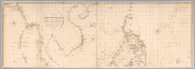
1812 Top sheet: Chart of the East India Islan … Chart Map (Top sheet of) Chart of the East India I … |

1812 Bottom sheet: Chart of the East India Is … Chart Map (Bottom sheet of) Chart of the East Indi … |

1812 Composite: Chart of the East India Islan … Chart Map (Composite of) Chart of the East India I … |

1771 Indes III. World Atlas Carte hydro-geo-graphique des Indes Orie … |

1771 Indes IV. World Atlas (Carte hydro-geo-graphique des Indes Ori … |

1967 South-East Asia. Pergamon World Atlas. World Atlas South-East Asia. Pergamon World Atlas. P … |

1813 East India Isles. World Atlas East India Isles. Drawn under the direct … |