Browse All

1736 The N.E. part of Germany. World Atlas The N.E. part of Germany. Containing ye … |

1884 Prussia, German States. World Atlas Prussia, and the German States. Copyrigh … |

1859 Prussia. World Atlas Prussia. Entered according to Act of Con … |

1790 Map of the Empire of Germany (Northern s … World Atlas Map of the Empire of Germany, including … |

1787 A new map of the Kingdom of Poland with … World Atlas A new map of the Kingdom of Poland with … |

1935 Allemagne, Pologne, Tchecoslovaquie. World Atlas Allemagne, Pologne, Tchecoslovaquie. Car … |

1810 Prussian Dominions. World Atlas Prussian Dominions. Drawn under the dire … |

1893 Empire of Germany (northern portion). World Atlas Empire of Germany (northern portion). (w … |

1893 South-West Russia. World Atlas South-West Russia. Sowing the Extent of … |

1814 Poland. World Atlas Poland. Drawn under the direction of Mr. … |

1824 Carte Generale du Royaume de Prusse. World Atlas Carte Generale du Royaume de Prusse et s … |

1823 Carte Generale du Royaume de Polonge. World Atlas Carte Generale du Royaume de Pologne ava … |

1824 Carte de Nouve au Royaume de Polonge. World Atlas Carte de Nouveau Royaume de Pologne rele … |

1810 Germany north of the Mayn. World Atlas Germany north of the Mayn. Drawn under t … |

1826 Germania Antiqua. (1826) Classical Atlas Germania Antiqua. Published by H.S. Tann … |

1886 Prussia, German States. World Atlas Prussia, and the German States. Copyrigh … |

1882 Europe Centrale (Partie Centrale). World Atlas Europe Centrale (Partie Centrale). Atlas … |

1889 Germany Northern Portion. National Atlas Rand, McNally & Co.'s Germany Northern P … |

1854 Prussia. World Atlas Prussia. Edinburgh, Published by A. &. C … |

1910 Empire of Germany (northern portion). World Atlas Empire of Germany (northern portion). (w … |

1912 South-West Russia. World Atlas South-West Russia. (with) Odessa. Showin … |

1824 Germany. World Atlas Germany. Young & Delleker Sc. Published … |

1824 Prussia. World Atlas Prussia. Young & Delleker Sc. Published … |

1886 Empire of Germany. World Atlas Johnson's Empire of Germany. Published b … |

1818 Poland. World Atlas Poland. |

1878 Germany, Austria, and Switzerland. World Atlas Germany, Austria, and Switzerland. Drawn … |

1967 Map Title Page: 7-8. Union of Soviet Soc … World Atlas (Map Title Page) 7-8. Union of Soviet So … |

1967 7-8. Union of Soviet Socialist Republics … World Atlas 7-8. Union of Soviet Socialist Republics … |

1967 9. Union of Soviet Socialist Republics, … World Atlas 9. Union of Soviet Socialist Republics, … |

1967 Map Title Page: 10-11. Union of Soviet S … World Atlas (Map Title Page) 10-11. Union of Soviet … |

1967 10-11. Union of Soviet Socialist Republi … World Atlas 10-11. Union of Soviet Socialist Republi … |
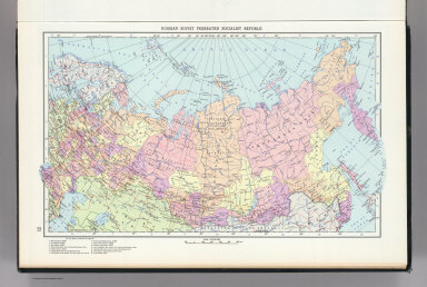
1967 12. Russian Soviet Federated Socialist R … World Atlas 12. Russian Soviet Federated Socialist R … |

1967 13-14. Soviet Union in Europe. The World … World Atlas 13-14. Soviet Union in Europe. The World … |

1967 79-80. Europe, Central. The World Atlas. World Atlas 79-80. Europe, Central. The World Atlas. |

1967 Map Title Page: 87-88. Poland. 89. Czech … World Atlas (Map Title Page) 87-88. Poland. 89. Czec … |

1967 87-88. Poland. The World Atlas. World Atlas 87-88. Poland. The World Atlas. |

1751 Haute Saxe septentrionale. World Atlas Partie Septentrionale du Cercle de Haute … |

1751 Boheme, Silesie, Moravie et Lusace. World Atlas Le Royaume de Boheme, le Duche de Silesi … |

1757 Allemagne postes. World Atlas Carte de l'Empire d'Allemagne ou sont ma … |