Who What Where When |
REFINE
Browse All : Images of Prussia, East (Poland and Russia)
1-6 of 6
Author
Cary, John, ca. 1754-1835
Full Title
A new map of the Kingdom of Prussia, with its divisions into provinces and governments; from the latest authorities. By John Cary, engraver, 1799. London: Printed for J. Cary, Engraver & Map-seller, No. 181, Strand, Aug. 1st., 1799.
Publisher
John Cary
Author
[Edward Stanford Ltd., Stanford, Edward]
Full Title
German Empire (eastern part) and Poland. London atlas series. Stanford's Geographical Estabt. London : Edward Stanford, 26 & 27 Cockspur St., Charing Cross, S.W. (1901)
Publisher
Edward Stanford
Author
Flemming, Carl
Full Title
Ost-Preussen. Entw. u. gezeichnet v. Handtke. Lith., Druck u. Verlag von C. Flemming in Glogau. (1855)
Publisher
C. Flemming
Author
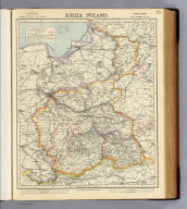
Letts, Son & Co.
Full Title
Russia (Poland). Extra sheet. Letts's popular atlas. Letts, Son & Co. Limited, London. (1883)
Publisher
Letts, Son & Co.
Author
Touring club italiano
Full Title
Prussia orientale, Ostpreussen. Stati Baltici: Estonia, Lettonia, Lituania, Eesti, Lavtija, Lietuva. Propr. Artistico-letteraria del T.C.I. Ufficio cartografico del T.C.I. (1929)
Publisher
Touring club italiano
1-6 of 6
|