Who What Where WhenREMOVEWHATShow LessWHO
WHEN |
REFINE
Browse All : Images of Rhode Island and Connecticut from 1832
1-4 of 4
Author
Andrus & Judd
Full Title
(Covers to) The States Of Massachusetts, Connecticut And Rhode Island From the best Authorities. Published by Andrus & Judd Hartford, Conn. 1832. Copy Right secured according to Act of Congress.
Publisher
Andrus & Judd
Author
Andrus & Judd
Full Title
The States Of Massachusetts, Connecticut And Rhode Island From the best Authorities. Published by Andrus & Judd Hartford, Conn. 1832. Copy Right secured according to Act of Congress.
Publisher
Andrus & Judd
Author
[Hinton, Isaac Taylor, 1799-1847, Simpkin & Marshall]
Full Title
Map of the states of Massachusetts and Connecticut, and Rhode Island. (with) Plan of Boston &c. London, published Feb. 1, 1832 by I.T. Hinton & Simpkin & Marshall. Engraved & printed by Fenner Sears & Co. (1832)
Publisher
[Simpkin & Marshall, Thomas Wardle]
Author
Burr, David H., 1803-1875
Full Title
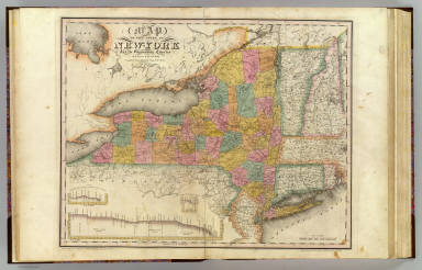
Map of the State of New-York and the surrounding country by David H. Burr. Compiled from his large map of the State, 1832. (with) Profile of the Grand Erie Canal. (with) Profile of the Champlain Canal. (with) Profile of the Seneca Canal. Entered according to Act of Congress Jany. 5th., 1829 by David H. Burr of the State of New York. Engd. by Rawdon, Clark & Co., Albany & Rawdon, Wright & Co., New York.
Publisher
D.H. Burr
1-4 of 4
|


