1890
Mass., Conn., R.I.
World Atlas
County and township map of the states of
…
|

1823
Mass., R.I., Conn.
National Atlas
Massachusetts, Rhode-Island and Connecti
…
|

1840
Massachusetts. Rhode Island. And Connect
…
World Atlas
Massachusetts. Rhode Island. And Connect
…
|

1870
Mass., Conn., R.I.
[State Atlas, World Atlas]
County map of Massachusetts, Connecticut
…
|

1880
Mass., Conn., R.I.
World Atlas
County and township map of the states of
…
|

1796
Rhode Island.
National Atlas
Rhode Island. W. Barker sculp. Philada.
|

1795
State of Rhode Island.
World Atlas
The State of Rhode Island; compiled from
…
|

1796
State of Rhode Island.
World Atlas
The State of Rhode Island; compiled from
…
|

1758
New England
World Atlas
New England. (to accompany) Atlas Minimu
…
|

1966
Continental Glaciation. Terminal Moraine
…
Physical Atlas
Continental Glaciation. Terminal Moraine
…
|

1859
Massachusetts and Rhode Island.
World Atlas
Map of Massachusetts and Rhode Island. P
…
|

1905
Complete Road Atlas, Massachusetts And R
…
Regional Atlas
Complete Road Atlas Massachusetts and Rh
…
|

1905
Composite: Sheets 1 - 5. Scarborough's C
…
Regional Atlas
(Composite of) Sheets 1 - 5. Scarborough
…
|

1940
Road map of Connecticut, Massachusetts,
…
National Atlas
Rand McNally Road map, Connecticut, Mass
…
|

1842
Winsor Farm.
Manuscript Map
A plat of Serril Winsor Esqr. Farm situa
…
|

1811
Rhode Island.
World Atlas
The State of Rhode Island; compiled from
…
|

1885
Rhode Island, Connecticut
National Atlas
Rhode Island, Connecticut. (to accompany
…
|

1935
Rhode Island.
National Atlas
Rhode Island.
|

1883
Massachusetts, Rhode Island, and Connect
…
World Atlas
Massachusetts, Rhode Island, & Connectic
…
|

1838
Connecticut and Rhode Island
World Atlas
Connecticut and Rhode Island. (to accomp
…
|

1845
Massachusetts and Rhode Island
National Atlas
Massachusetts and Rhode Island. (to acco
…
|

1873
Massachusetts and Rhode Island.
World Atlas
Gray's Atlas Map of Massachusetts and Rh
…
|

1893
14. Putnam sheet.
State Atlas
No. 14. Connecticut-Rhode Island. Putnam
…
|

1827
Massachusetts, Connecticut, and Rhode Is
…
National Atlas
Map of Massachusetts, Connecticut, and R
…
|

1893
22. Moosup sheet.
State Atlas
No. 22. Connecticut-Rhode Island. Moosup
…
|

1876
Massachusetts, Rhode Island, and Connect
…
National Atlas
Gray's New Map of Massachusetts, Rhode I
…
|

1893
30. Stonington sheet.
State Atlas
No. 30. Conn.-R.I.-N.Y. Stonington sheet
…
|

1890
24. Blackstone sheet.
State Atlas
Massachusetts-Rhode Island. Blackstone s
…
|

1890
27. Franklin sheet.
State Atlas
Massachusetts-Rhode Island. Franklin she
…
|

1891
Map of Rhode Island, 96
World Atlas
Map of Rhode Island. Copyright 1891 by M
…
|

1939
Rand McNally Road map: Connecticut, Mass
…
National Atlas
Rand McNally Road map: Connecticut, Mass
…
|

1845
Massachusetts and Rhode Island
National Atlas
Massachusetts and Rhode Island. (By Sidn
…
|

1846
Massachusetts And Rhode Island.
World Atlas
Massachusetts And Rhode Island: (with) B
…
|

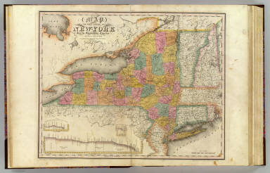
1832
New-York State, surrounding country.
State Atlas
Map of the State of New-York and the sur
…
|

1797
Rhode Island.
National Atlas
Rhode Island entworfen von D.F. Sotzmann
…
|

1795
State of Rhode Island.
National Atlas
The State of Rhode Island compiled from
…
|

1862
War Telegram Marking Map.
Separate Map
War Telegram Marking Map. L. Prang & Co.
…
|

1889
Florida, Virginia, Indiana, Rhode Island
…
National Atlas
Florida, Virginia, Indiana, Rhode Island
…
|

1831
Map of Massachusetts, Connecticut, and R
…
National Atlas
Map Of Massachusetts, Connecticut And Rh
…
|

1865
Massachusetts and Rhode Island, Vicinity
…
World Atlas
Colton's Massachusetts and Rhode Island.
…
|

1865
Connecticut with Portions of New York &
…
World Atlas
Colton's Connecticut with Portion of New
…
|

1869
Massachusetts, Connecticut and Rhode Isl
…
World Atlas
Colton's Massachusetts, Connecticut and
…
|

1852
New York, New Jersey, Massachusetts, Con
…
National Atlas
(New York, New Jersey, Massachusetts, Co
…
|

1827
Massachusetts, Connecticut, Rhode Island
…
National Atlas
Map of Massachusetts, Connecticut, and R
…
|

1948
Massachusetts, Connecticut, and Rhode Is
…
World Atlas
Southern New England. Massachusetts, Con
…
|

1864
Vermont, New Hampshire, Massachusetts, R
…
World Atlas
Johnson's Vermont, New Hampshire, Massac
…
|

1864
Massachusetts, Connecticut, And Rhode Is
…
World Atlas
Johnson's Massachusetts, Connecticut, An
…
|

1874
Massachusetts. Rhode Island.
World Atlas
Gray's Atlas Map of Massachusetts and Rh
…
|

1924
Text Page: Industrial Statistics of the
…
National Atlas
(Text Page) Industrial Statistics of the
…
|

1924
Connecticut, Massachusetts, and Rhode Is
…
National Atlas
Commercial Atlas of America. Rand McNall
…
|