Who What Where WhenREMOVEWHERE
|
REFINE
Browse All : Images of San Francisco Bay (Calif.)
1-16 of 16
Author
Duflot de Mofras, Eugene
Full Title
Port De San Francisco Dans La Haute Californie. No. 16. (with) Entree Du Port De San Francisco et des mouillages del Sausalito et de la Yerba Buena. Publie Par Arthus Bertrand. Grave par S. Jacobs. Voyage de Mr. Duflot de Mofras.
Publisher
Arthus Bertrand
Author
[Arnold, T. J. (Thomas Jefferson), d. 1878, California. Board of State Harbor Commissioners for San Francisco Harbor]
Full Title
Map exhibiting the salt marsh, tide and submerged lands disposed of by the State of California in and adjacent to the bays of San Francisco and San Pablo and now subject to reclamation. Prepared from maps of the U.S. Coast Survey & official records by order of the Board of State Harbor Commissioners for the United States Commissioners on San Francisco Harbor. By T.J. Arnold, engineer of the sea wall. 1874. U.S. Commissioners Rear Admiral John Rodgers, Major G.H. Mendell, Prof. George Davidson. State Harbor Commissioners Samuel Soule, T.D. Mathewson, D.C. McRuer. Britton Rey & Co. Lith. S.F.
Publisher
Britton & Rey
Author
Vancouver, George, 1757-1798
Full Title
A Chart shewing part of the Coast of N.W. America, With the Tracks of His Majesty's Sloop Discovery and Armed Tender Chatham; Commanded by George Vancouver Esqr. and prepared under his immediate inspection by Lieut. Joseph Baker, in which the Continental Shore has been traced and determined from Lat. 30¼00'N. and Long. 244¼32' E. to Lat. 38¼30'N and Long 237¼13'E. Engraved by T. Foot, Weston Place, Battle Bridge. No. 8. (with) Entrance of Port Sn. Francisco. (and) Port Sn. Diego. London: Published May 1st 1798, by J. Edwards Pall Mall & G. Robinson Paternoster Row.
Publisher
G.G. & J. Robinson
Full Title
View of the Golden Gate from the Bay, looking west. (By Daniel H. Burnham. Assisted by Edward H. Bennett. 1905)
Publisher
City of San Francisco
Full Title
View of water-front from Bay. (By Daniel H. Burnham. Assisted by Edward H. Bennett. 1905)
Publisher
City of San Francisco
Full Title
Panorama of the Bay from the Presidio, looking east. View of the Golden Gate from the proposed terrace in the Presidio. (By Daniel H. Burnham. Assisted by Edward H. Bennett. 1905)
Publisher
City of San Francisco
Author
[Ringgold, Cadwalader, 1802-1867, Stuart, F. D. (Fred. D.)]
Full Title
Chart of the Bay of San Pablo Straits Of Carquines and part of the Bay of San Francisco California By Cadwalader Ringgold Commander, U.S. Navy. Assisted by Simon F. Blunt, Lieut. U.S.N. 1850. Projected, Constructed & Drawn by Fred. D. Stuart, Hydrographer, late of the U.S. Ex.Ex. Assisted by A.H. Campbell, Civil Engineer. Entered ... 1851, by Cadwalader Ringgold ... District of Columbia. C.B. Graham, Lithr. Washington, D.C.
Publisher
Jno. T. Towers
Author
[Dougal, William H., 1822-1895, Ringgold, Cadwalader, 1802-1867]
Full Title
Entrance to San Francisco. C. Ringgold, U.S.N. W.H. Dougal. (Washington: printed by Jno. T. Towers, 1852)
Publisher
Jno. T. Towers
Author
[Blunt, Simon F., Ringgold, Cadwalader, 1802-1867, Stuart, F. D. (Fred. D.)]
Full Title
Chart of the Farallones and entrance to the Bay of San Francisco, California by Cadwalader Ringgold, Commander, U.S. Navy. Assisted by Simon F. Blunt, Lieut. U.S. Navy, 1850. Constructed, projected and drawn by Fred. D. Stuart, hydrographer, late of the U.S. Ex. Ex. C.B. Graham, Lithr., Washington, D.C. Entered ... 1851, by Cadwalader Ringgold ... District of Columbia.
Publisher
Jno. T. Towers
Author
Ringgold, Cadwalader, 1802-1867
Full Title
(Covers to) A Series of charts, with sailing directions, embracing surveys of the Farallones, entrance to the Bay of San Francisco ... State of California... Third edition, with additions.
Publisher
Jno. T. Towers
Author
Ringgold, Cadwalader, 1802-1867
Full Title
(Title Page to) A Series of charts, with sailing directions, embracing surveys of the Farallones, entrance to the Bay of San Francisco ... State of California... Third edition, with additions.
Publisher
Jno. T. Towers
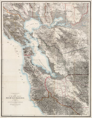
Author
[Hoffmann, Charles F., Whitney, J.D., Geological Survey of California]
Full Title
(North Sheet) State Geological Survey Of California. J.D. Whitney, State Geologist. Map Of The Region Adjacent To The Bay Of San Francisco. 1873. The Coast, Rancho, Township and Section Lines from Materials furnished by the U.S. Coast Survey and the U.S. Surveyor General's Office, the Topography chiefly from Original Surveys by C.F. Hoffman ... Julius Bien, Lith.
Publisher
Julius Bien
Author
[Hoffmann, Charles F., Whitney, J.D., Geological Survey of California]
Full Title
(South Sheet) State Geological Survey Of California. J.D. Whitney, State Geologist. Map Of The Region Adjacent To The Bay Of San Francisco. 1873. The Coast, Rancho, Township and Section Lines from Materials furnished by the U.S. Coast Survey and the U.S. Surveyor General's Office, the Topography chiefly from Original Surveys by C.F. Hoffman ... Julius Bien, Lith.
Publisher
Julius Bien
Author
[Hoffmann, Charles F., Whitney, J.D., Geological Survey of California]
Full Title
(Covers to) State Geological Survey Of California. J.D. Whitney, State Geologist. Map Of The Region Adjacent To The Bay Of San Francisco. 1873. The Coast, Rancho, Township and Section Lines from Materials furnished by the U.S. Coast Survey and the U.S. Surveyor General's Office, the Topography chiefly from Original Surveys by C.F. Hoffman ... Julius Bien, Lith.
Publisher
Julius Bien
Author
[Hoffmann, Charles F., Whitney, J.D., Geological Survey of California]
Full Title
(Composite) State Geological Survey Of California. J.D. Whitney, State Geologist. Map Of The Region Adjacent To The Bay Of San Francisco. 1873. The Coast, Rancho, Township and Section Lines from Materials furnished by the U.S. Coast Survey and the U.S. Surveyor General's Office, the Topography chiefly from Original Surveys by C.F. Hoffman ... Julius Bien, Lith.
Publisher
Julius Bien
Author
United States Coast Survey
Full Title
Entrance to San Francisco Bay California. From a Trigonometrical Survey under the direction of A.D. Bache Superintendent of the Survey Of The Coast Of The United States. Triangulation by R.D. Cutts Asst. & A.F. Rodgers Sub-Assts. Hydrography by the Party under the command of Lieut. Comdg. James Alden U.S.N. Asst. 1859. U.S. Coast Survey Office. Verified W.R. Palmer ... No. 36. Redd. Drng. by W.M.C. Fairfax, J. Lambert, & J.J. Ricketts. Engd. by J. Knight, A. Blondeau & G.B. Metzeroth. Electrotype Copy No. 2 by G. Mathiot U.S.C.S. (inset map) Sub-Sketch Of Entrance To San Francisco Bay. 1859.).
Publisher
U.S. Coast Survey
1-16 of 16
|