Browse All

1894 City And County Of San Francisco Califor … Pocket Map Faust's Map Of City And County Of San Fr … |
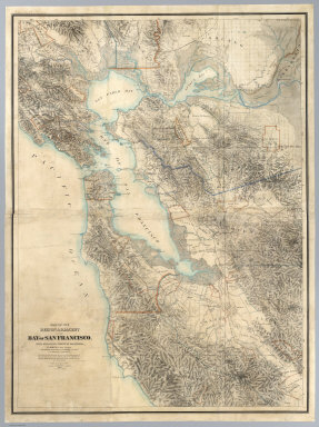
1867 Map Of The Region Adjacent To The Bay Of … Wall Map Map Of The Region Adjacent To The Bay Of … |

1861 City And County Of San Francisco. Separate Map City And County Of San Francisco. Compil … |

1944 Commercial and school map of California; … Separate Map Commercial and school map of California … |

1874 County map of the state of California World Atlas County map of the state of California. E … |

1868 County map of California. Map of the Set … World Atlas County map of California (inset maps) 52 … |
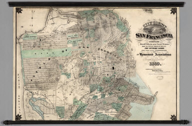
1869 City and County of San Francisco. Wall Map City and County of San Francisco. Compil … |

1857 New Orleans. San Francisco. National Atlas New Orleans. San Francisco. London ... & … |

1905 Cover: Report on plan for San Francisco. City Atlas (Covers to) Report on a plan for San Fra … |

1905 Title Page: Report on plan for San Franc … City Atlas (Title Page to) Report on a plan for San … |

1905 Contents: Report on plan for San Francis … City Atlas (Contents to) Report on a plan for San F … |

1905 Contents: Report on plan for San Francis … City Atlas (Contents to) Report on a plan for San F … |

1905 Preface: Report on plan for San Francisc … City Atlas (Preface to) Report on a plan for San Fr … |

1905 Preface: Report on plan for San Francisc … City Atlas (Preface to) Report on a plan for San Fr … |

1905 Bird's-eye view, San Francisco. City Atlas Bird's-eye view of the city of San Franc … |

1905 Panorama from Twin Peaks. City Atlas Panorama of the City from Twin Peaks. (B … |

1905 View of Golden Gate looking west. City Atlas View of the Golden Gate from the Bay, lo … |

1905 View of water-front from Bay. City Atlas View of water-front from Bay. (By Daniel … |

1905 Bird's-eye perspective from Twin Peaks s … City Atlas Bird's-eye perspective of the City from … |

1905 Bird's-eye perspective from the east sho … City Atlas Bird's-eye perspective of the City from … |

1905 San Francisco, system of circuit, radial … City Atlas Plan of San Francisco, showing system of … |

1905 Yacht harbor, E. of Ft. Mason. City Atlas View of the natural yacht harbor, skirte … |

1905 The Bay near Fishermen's Wharf. City Atlas The Bay, looking north from proposed Out … |

1905 Panorama of Bay from Presidio; Golden Ga … City Atlas Panorama of the Bay from the Presidio, l … |

1905 Ocean, headlands from Cliff House Rocks. City Atlas View of the ocean and headlands, north, … |

1905 Ocean south from Cliff House Rocks. City Atlas View of the ocean, south, from the propo … |

1905 Laguna de la Merced, looking west. City Atlas View of Laguna de la Merced, looking wes … |

1905 City Hall from 8th St. City Atlas View of the City Hall, from Eighth Stree … |

1905 Golden Gate from Ashbury & 17th streets. City Atlas View of the Golden Gate, from Ashbury an … |

1905 Twin Peaks from proposed square, 23rd & … City Atlas View of Twin Peaks, from the proposed sq … |

1905 Glen Canyon, Twin Peaks. City Atlas Glen Canyon, showing the Twin Peaks Grou … |

1905 Driveway, Glen Canyon. City Atlas View of driveway through Glen Canyon. (B … |

1905 Market Street termination, approach to T … City Atlas Market Street termination and approach t … |

1905 Panhandle extension, section. City Atlas Panhandle, plan of proposed extension fr … |

1905 Sections, Steiner & Fillmore streets. City Atlas Section at Steiner Street, through A and … |

1905 Plan, Civic Center. City Atlas Plan of Civic Center. (By Daniel H. Burn … |

1905 View of Civic Center. City Atlas View of Civic Center, looking from the s … |

1905 Playground, Washington Square. City Atlas Typical plan of playground north of Wash … |

1905 Twin Peaks Group from Herman & Buchanan. City Atlas View of the Twin Peaks Group, from Herma … |

1905 Golden Gate from Twin Peaks. City Atlas View of the Golden Gate from Twin Peaks. … |

1905 Panorama from Twin Peaks west to the sea … City Atlas Panorama: looking from Twin Peaks west t … |

1905 View from Twin Peaks showing South San F … City Atlas View from Twin Peaks, showing South San … |

1905 View from Telegraph Hill looking west. City Atlas View from Telegraph Hill, looking west. … |

1905 View from Telegraph Hill looking north. City Atlas View from Telegraph Hill, looking north. … |

1905 View from Telegraph Hill looking east. City Atlas View from Telegraph Hill, looking east. … |

1905 Buena Vista Park, City, from Twin Peaks. City Atlas View of Buena Vista Park and City, from … |

1905 Twin Peaks, from Market St. near Larkin … City Atlas View of Twin Peaks, from Market Street, … |

1905 Twin Peaks from Market & Noe streets. City Atlas View of Twin Peaks, from Market and Noe … |

1905 Twin Peaks from Clarendon Heights lookin … City Atlas Twin Peaks, from Clarendon Heights, look … |

1905 The valley, west from the proposed Athen … City Atlas View of the valley, west from the propos … |