Browse All

1844 Port De San Francisco Dans La Haute Cali … Exploration Book Port De San Francisco Dans La Haute Cali … |

1874 Map exhibiting the salt marsh ... lands … [Chart Map, Wall Map] Map exhibiting the salt marsh, tide and … |

1798 The Coast of N.W. America. Chart Atlas A Chart shewing part of the Coast of N.W … |

1905 View of Golden Gate looking west. City Atlas View of the Golden Gate from the Bay, lo … |

1905 View of water-front from Bay. City Atlas View of water-front from Bay. (By Daniel … |

1905 Panorama of Bay from Presidio; Golden Ga … City Atlas Panorama of the Bay from the Presidio, l … |

1852 San Pablo Bay, Carquines Straits. Chart Map Chart of the Bay of San Pablo Straits Of … |

1852 Entrance, San Francisco. Chart Map Entrance to San Francisco. C. Ringgold, … |

1852 Farallones, San Francisco Bay. Chart Map Chart of the Farallones and entrance to … |

1852 Cover: Series of charts, sailing directi … Chart Map (Covers to) A Series of charts, with sai … |

1852 Title Page: Series of Charts, sailing di … Chart Map (Title Page to) A Series of charts, with … |

1873 North Sheet: Map Of The Region Adjacent … Pocket Map (North Sheet) State Geological Survey Of … |

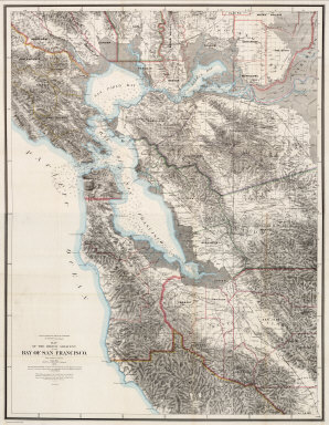
1873 South Sheet: Map Of The Region Adjacent … Pocket Map (South Sheet) State Geological Survey Of … |

1873 Covers to: Map Of The Region Adjacent To … Pocket Map (Covers to) State Geological Survey Of C … |
1873 Composite: Map Of The Region Adjacent To … Pocket Map (Composite) State Geological Survey Of C … |

1859 Entrance to San Francisco Bay California … Chart Map Entrance to San Francisco Bay California … |