Who What Where WhenREMOVEWHO
WHEN |
REFINE
Browse All : Images of South Dakota from 1874
1-8 of 8
Author
Asher & Adams
Full Title
Asher & Adams' Dakota. Entered according to Act of Congress in the year 1874 by Asher & Adams ... at Washington. (New York, 1874)
Publisher
Asher and Adams
Author
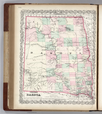
Colton, G.W.
Full Title
Colton's Dakota. Published By G. W & C. B. Colton & Co. No. 172 William St. New York.
Publisher
G. W & C. B. Colton & Co.
Author
Mitchell, Samuel Augustus Jr.
Full Title
County Map of Colorado, Wyoming, Dakota, Montana.
Publisher
Ziegler & McCurdy
Author
Mitchell, Samuel Augustus Jr.
Full Title
County map of Colorado, Wyoming, Dakota, Montana. Entered ... 1874, by S. Augustus Mitchell ... Washington.
Publisher
S.A. Mitchell Jr.
Author
Gray, Ormando Willis
Full Title
Gray's Atlas Map of Wisconsin. (inset) Vicinity of Milwaukee. Dakota.
Publisher
Stedman, Brown & Lyon
Author
[Ludlow, William, 1843-1901, United States. Army. Corps of Engineer]
Full Title
A geological map of the Black Hills: by Professor N.H. Winchell to accompany the report of Capt. William Ludlow U.S. Engineers. (to accompany) Report of a reconnaissance of the Black Hills of Dakota, made in the summer of 1874. By William Ludlow, Captain of Engineers, Bvt. Lieut. Colonel, U. S. Army; Chief Engineer Department of Dakota. Washington : Government Printing Office. 1875.
Publisher
Government Printing Office
Author
[Ludlow, William, 1843-1901, United States. Army. Corps of Engineer]
Full Title
Map of a reconnaissance of the Black Hills of Dakota, July and August 1874. With troops under command of Lt. Col. G.A.Custer, 7th., Cavalry, by Capt. Wm. Ludlow, Corps of Engineers. (on upper margin) Brig. Genl. A.A.Humphreys, Chief of Engineers U.S.A. ; Brig. Genl. A.H. Terry Comdg. Department. (to accompany) Report of a reconnaissance of the Black Hills of Dakota, made in the summer of 1874. By William Ludlow, Captain of Engineers, Bvt. Lieut. Colonel, U. S. Army; Chief Engineer Department of Dakota. Washington : Government Printing Office. 1875.
Publisher
Government Printing Office
Author
[Ludlow, William, 1843-1901, United States. Army. Corps of Engineer]
Full Title
Map of the Black Hills from a reconnaissance by Capt. Wm. Ludlow, Corps of Engineers. 1874, and map of Warren and Raynolds. Drawn by Sergt. C. Becker. (to accompany) Report of a reconnaissance of the Black Hills of Dakota, made in the summer of 1874. By William Ludlow, Captain of Engineers, Bvt. Lieut. Colonel, U. S. Army; Chief Engineer Department of Dakota. Washington : Government Printing Office. 1875.
Publisher
Government Printing Office
1-8 of 8
|