Who What Where WhenREMOVEWHOShow MoreWHEN
|
Author
[Breese, Samuel, 1802-1873, Morse, Sidney E. (Sidney Edwards), 1794-1871, Nicollet, J. N. (Joseph Nicolas), 1786-1843]
Full Title
Iowa and Wisconsin. Chiefly from the map of N.J. Nicollet. Entered ... 1844 by Sidney E. Morse and Samuel Breese ... New York. (New York: Published by Harper & Brothers, 1845)
Publisher
Harper & Brothers
Author
[International & Great Northern Railroad, Rand McNally and Company]
Full Title
(Covers to:) The Lone Star guide descriptive of counties on the line of the International and Great Northern Railroad of Texas ... Woodward, Tiernan & Hale, Printers, St. Louis.
Publisher
Woodward, Tiernan & Hale
Author
[International & Great Northern Railroad, Rand McNally and Company]
Full Title
Map of the International and Great Northern Railroad. Lone (Star) route and connections. Woodward, Tiernan & Hale, Map Engravers, St. Louis. Rand, McNally & Co, Map Engr's Chicago. (1878)
Publisher
Woodward, Tiernan & Hale
Author
St. Louis, Iron Mountain, and Southern Railway Company
Full Title
(Covers to:) Texas Short Line. St. Louis, Iron Mountain & Southern Ry. from St. Louis to Arkansas and to Texas ... The company's offices, No. 513 North Fifth Street, St. Louis and at Plum Street Depot ... A.W. Soper, General Superintendent, St. Louis, Mo. Woodward, Tiernan & Hale, Printers, St. Louis.
Publisher
St. Louis, Iron Mountain, and Southern Railway Company
Author
St. Louis, Iron Mountain, and Southern Railway Company
Full Title
Texas Short Line. St. Louis, Iron Mountain & Southern Ry. from St. Louis to Arkansas and to Texas ... The company's offices, No. 513 North Fifth Street, St. Louis and at Plum Street Depot ... A.W. Soper, General Superintendent, St. Louis, Mo. Woodward, Tiernan & Hale, Printers, St. Louis.
Publisher
St. Louis, Iron Mountain, and Southern Railway Company
Author
St. Louis, Iron Mountain, and Southern Railway Company
Full Title
A geographically correct county map of states traversed by the St. Louis, Iron Mountain and Southern Railway and its connections. (with) Map of the St. Louis, Iron Mountain and Southern Railway, and connections. Maps of the new and popular St. Louis and Texas Short Line! ...
Publisher
Texas & Pacific Railway Company.
Author
Colton, G.W. & C.B.
Full Title
Map showing the Route of the Duluth & Winnipeg Railroad And Its Connections. Prepared By G.W. & C.B. Colton & Co. 182 William Street New York. Entered ... 1881 by G.W. & C.B. Colton & Co. ... Washington.
Publisher
G.W. & C.B. colton & Co.
Author
Cram, George Franklin
Full Title
(Covers to) Cram's Township And Rail Road Map Of The North West. Published By George F. Cram, Proprietor Of The Western Map Depot. 66 Lake St.: Chicago, Ills. 1878. Entered ... 1878, by G.F. Cram ... Washington D.C.
Publisher
George F. Cram
Author
Cram, George Franklin
Full Title
Cram's Township And Rail Road Map Of The North West. Published By George F. Cram, Proprietor Of The Western Map Depot. 66 Lake St.: Chicago, Ills. 1878. Entered ... 1878, by G.F. Cram ... Washington D.C.
Publisher
George F. Cram
Author
Colton, J. H.
Full Title
Nebraska and Kansas. Published by J.H. Colton & Co. No. 172 William St., New York. Entered ... 1854 by J.H. Colton & Co. ... New York. (with) Map of the territory acquired from Mexico by the Gadsden Treaty, 1854. (with untitled inset of U.S., Mexico, Central America). Printed by D. McLellan, 26 Spruce St., N.Y.
Publisher
J.H. Colton & Co.
Author
Colton, J. H.
Full Title
(Covers to) Nebraska and Kansas. Published by J.H. Colton & Co. No. 172 William St., New York. Entered ... 1854 by J.H. Colton & Co. ... New York. Printed by D. McLellan, 26 Spruce St., N.Y.
Publisher
J.H. Colton & Co.
Author
Colton, J. H.
Full Title
(Inside Covers to) Nebraska and Kansas. Published by J.H. Colton & Co. No. 172 William St., New York. Entered ... 1854 by J.H. Colton & Co. ... New York. Printed by D. McLellan, 26 Spruce St., N.Y.
Publisher
J.H. Colton & Co.
Author
Colton, J. H.
Full Title
Nebraska and Kansas. Published by J.H. Colton & Co. No. 172 William St., New York, 1857. (with) Territory acquired from Mexico by the Gadsden Treaty. (with untitled inset of eastern Nebraska and Kansas and western Iowa and Missouri).
Publisher
J.H. Colton & Co.
Author
Colton, J. H.
Full Title
(Covers to) Nebraska and Kansas. Published by J.H. Colton & Co. No. 172 William St., New York, 1857.
Publisher
J.H. Colton & Co.
Author
Colton, J. H.
Full Title
(Inside Covers to) Nebraska and Kansas. Published by J.H. Colton & Co. No. 172 William St., New York, 1857.
Publisher
J.H. Colton & Co.
Author
Colton, J. H.
Full Title
Nebraska and Kansas. Published by J.H. Colton & Co. No. 172 William St., New York, (1855). Entered ... 1855 by J.H. Colton ... New York. (with) Territory acquired from Mexico by the Gadsden Treaty. (untitled inset of U.S., Mexico, Central America)
Publisher
J.H. Colton & Co.
Author
Colton, J. H.
Full Title
(Covers to) Nebraska and Kansas. Published by J.H. Colton & Co. No. 172 William St., New York, (1855). Entered ... 1855 by J.H. Colton ... New York.
Publisher
J.H. Colton & Co.
Author
Colton, J. H.
Full Title
(Inside Covers to) Nebraska and Kansas. Published by J.H. Colton & Co. No. 172 William St., New York, (1855). Entered ... 1855 by J.H. Colton ... New York.
Publisher
J.H. Colton & Co.
Full Title
New topographical atlas and gazetteer of Indiana. Indiana, Illinois, Missouri, Ohio, Kentucky, Tennessee. (Indianapolis: Higgins & Ryan, 1870)
Publisher
Higgins & Ryan
Author
[Kensett, Thomas, Tardieu, P.F.]
Full Title
To the officers of the Army and the citizens of the United States this map of Upper and Lower Canada and United States, contigious (sic). Contracted from the manuscript surveys of P.F. Tardieu. Is respectfully inscribed by the public's most obedient servant Thomas Kensett. Copyright secured and entered ... November 4th, 1812. Kensett sculp. Cheshire, Conn.
Publisher
Thomas Kensett
Author
Scott, Joseph
Full Title
N.W. Territory.
Publisher
F. & R. Bailey
Author
Scott, Joseph
Full Title
S.W. Territory.
Publisher
F. & R. Bailey
Author
[Pacific Railroad Survey, Warren, Gouverneur Kemble, 1830-1882, Winterbotham, W.]
Full Title
Reduced section of a general map of North America. Drawn from the best surveys. 1795. To accompany Winterbotham's History. Published by John Reid, New York. Lith of J. Bien, 60 Fulton St., N.Y. U.S. Pacific R.R. Exp. & Surveys. Lt. Warren's Memoir Plate I. (1861)
Publisher
[A.O.P. Nicholson I-XI, T. Ford XII.]
Author
[Pacific Railroad Survey, Warren, Gouverneur Kemble, 1830-1882]
Full Title
Reduced section of a sketch of the western part of the continent of North America between latitudes 35 (degrees) and 52 (degrees) Nth. 1818. Lith of J. Bien, 60 Fulton St., N.Y. U.S. Pacific R.R. Exp. & Surveys. Lt. Warren's Memoir Plate II. (1861)
Publisher
[A.O.P. Nicholson I-XI, T. Ford XII.]
Author
[Pacific Railroad Survey, Warren, Gouverneur Kemble, 1830-1882]
Full Title
Reduced section of map of North America including all the recent geographical discoveries. 1826. Lith of J. Bien, 60 Fulton St., N.Y. U.S. Pacific R.R. Exp. & Surveys. Lt. Warren's Memoir Plate III. (1861)
Publisher
[A.O.P. Nicholson I-XI, T. Ford XII.]
Author
[Bonneville, Benjamin Louis Eulalie de, Pacific Railroad Survey, Warren, Gouverneur Kemble, 1830-1882]
Full Title
Reduced map of the territory west of the Rocky Mountains. By Capt. B.L.E. Bonneville, U.S.A. 1837. Lith of J. Bien, 60 Fulton St., N.Y. U.S. Pacific R.R. Exp. & Surveys. Lt. Warren's Memoir Plate IV. (1861)
Publisher
[A.O.P. Nicholson I-XI, T. Ford XII.]
Author
[Pacific Railroad Survey, Warren, Gouverneur Kemble, 1830-1882]
Full Title
(Covers to) Reports of Explorations and Surveys, to Ascertain the Most Practicable and Economical Route for a Railroad From the Mississippi River to the Pacific Ocean. Made Under the Direction of the Secretary of War, In 1853-56, According to Acts of Congress of March 3, 1853, May 31, 1854, and August 5, 1854. Volume XI. Washington: George W. Bowman, Printer. 1861. 36th Congress, 2d Session, Senate, Ex. Doc.
Publisher
[A.O.P. Nicholson I-XI, T. Ford XII.]
Author
[Pacific Railroad Survey, Warren, Gouverneur Kemble, 1830-1882]
Full Title
(Contents Page to) Reports of Explorations and Surveys, to Ascertain the Most Practicable and Economical Route for a Railroad From the Mississippi River to the Pacific Ocean. Made Under the Direction of the Secretary of War, In 1853-56, According to Acts of Congress of March 3, 1853, May 31, 1854, and August 5, 1854. Volume XI. Washington: George W. Bowman, Printer. 1861. 36th Congress, 2d Session, Senate, Ex. Doc.
Publisher
[A.O.P. Nicholson I-XI, T. Ford XII.]
Author
[Pacific Railroad Survey, Warren, Gouverneur Kemble, 1830-1882]
Full Title
(Title Page to) Memoir to accompany the Map of the territory of the United States from the Mississippi River to the Pacific Ocean, giving a brief account of each of the exploring expeditions since A.D. 1800, with a detailed description of the method adopted in compiling the general map. By Lieut. Gouverneur K. Warren, Corps of Topographical Engineers, U.S.A. 1859.
Publisher
[A.O.P. Nicholson I-XI, T. Ford XII.]
Author
[Pacific Railroad Survey, Warren, Gouverneur Kemble, 1830-1882]
Full Title
(Contents Page to) Memoir to accompany the Map of the territory of the United States from the Mississippi River to the Pacific Ocean, giving a brief account of each of the exploring expeditions since A.D. 1800, with a detailed description of the method adopted in compiling the general map. By Lieut. Gouverneur K. Warren, Corps of Topographical Engineers, U.S.A. 1859.
Publisher
[A.O.P. Nicholson I-XI, T. Ford XII.]
Author
[Pacific Railroad Survey, Warren, Gouverneur Kemble, 1830-1882]
Full Title
(Contents Page to) Topographical maps, profiles, and sketches to illustrate the various Reports of Surveys for railroad routes from the Mississippi River to the Pacific Ocean. Washington, D.C., 1861.
Publisher
[A.O.P. Nicholson I-XI, T. Ford XII.]
Author
Wyld, James, 1812-1887
Full Title
(Covers to) Wyld's Military Map Of The United States, The Northern States, And The Southern Confederate States: With The Forts, Harbours, Arsenals And Military Positions. James Wyld, 457 Strand; Charing Cross East And 2, Royal Exchange London. London, Published By James Wyld, Geographer To The Queen & H.R.H. The Prince Consort ... (with 4 inset maps).
Publisher
James Wyld
Author
Wyld, James, 1812-1887
Full Title
Wyld's Military Map Of The United States, The Northern States, And The Southern Confederate States: With The Forts, Harbours, Arsenals And Military Positions. James Wyld, 457 Strand; Charing Cross East And 2, Royal Exchange London. London, Published By James Wyld, Geographer To The Queen & H.R.H. The Prince Consort ... (with 4 inset maps).
Publisher
James Wyld
Author
Cooke, D.B & Co.
Full Title
(Covers to) D.B. Cooke & Co.'s Great Western Railway Guide. Exhibiting All Stations With Distances From Each other. Chicago, 1856. Entered ... 1856 by D.B. Cooke & Company. Middleton Wallace & Co. Lith. Cincinnati.
Publisher
Cooke, D.B & Co.
Author
Cooke, D.B & Co.
Full Title
D.B. Cooke & Co.'s Great Western Railway Guide. Exhibiting All Stations With Distances From Each other. Chicago, 1856. Entered ... 1856 by D.B. Cooke & Company. Middleton Wallace & Co. Lith. Cincinnati.
Publisher
Cooke, D.B & Co.
Author
Ferris, Jacob
Full Title
The States and Territories of The Great West; including Ohio, Indiana, Illinois, Missouri, Michigan, Wisconsin, Iowa, Minesota (sic), Kansas, and Nebraska ... Giving a Table of Distances ... with a Map and Numerous Illustrations. By Jacob Ferris. New York and Auburn: Miller, Orton, and Mulligan. Buffalo: E.F. Beadle. 1856. (on verso) Entered ... 1856, By E.F. Beadle ... New York.
Publisher
Miller, Orton, and Mulligan
Author
Ferris, Jacob
Full Title
(View) Early Immigration to the West.
Publisher
Miller, Orton, and Mulligan
Author
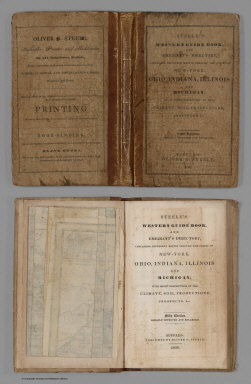
Steele, Oliver G.
Full Title
(Covers to) Steele's Western Guide Book, And Emigrant's Directory, Containing Different Routes Through The States Of New-York, Ohio, Indiana, Illinois And Michigan, With Short Descriptions Of The Climate, Soil, Productions, Prospects, &c. Fifth Edition. Greatly Improved And Enlarged. Buffalo: Published By Oliver G. Steele, 1836. (on verso) Entered ... in the year 1836 ... Press of O.G. Steele. (with) Steele's Map Of Ohio Indiana Illinois & Michigan From the Latest Authorities. Buffalo 1836. Entered ... 1835 by O.G. Steele ... Engraved by J.G. Darby, Buffalo N.Y. (inset) The Southern Part of Illinois.
Publisher
Oliver G. Steele.
Author
Steele, Oliver G.
Full Title
Steele's Map Of Ohio Indiana Illinois & Michigan From the Latest Authorities. Buffalo 1836. Entered ... 1835 by O.G. Steele ... Engraved by J.G. Darby, Buffalo N.Y. (inset) The Southern Part of Illinois.
Publisher
Oliver G. Steele.
Author
[Smith, J. Calvin, Colton, J.H.]
Full Title
Guide Through Ohio, Michigan, Indiana, Illinois, Missouri, Wisconsin & Iowa. Showing the Township lines of the United States Surveys ... By J. Calvin Smith. New York. Published by J.H. Colton, 86 Cedar St. engraved by Stiles, S. Sherman & Smith. At bottom, "Entered ... 1840, by J.C. Smith ... New York." (to accompany) The Western Tourist Or Emigrant's Guide Through The States of Ohio, Michigan, Indiana, Illinois, And Missouri, And The Territories Of Wisconsin And Iowa ... Accompanied with a Correct Map, showing the Township lines of the United States' Surveys ... New York: Published by J.H. Colton, 86 Cedar-Street. 1845. (on verso) Entered ... 1839, by J.H. Colton ... New-York.
Publisher
J.H. Colton
Author
[Smith, J. Calvin, Colton, J.H.]
Full Title
Guide through Ohio, Michigan, Indiana, Illinois, Missouri, Wisconsin & Iowa. Showing the Township lines of the United States Surveys ... By J. Calvin Smith. New York. Published by J.H. Colton, 86 Cedar St. Engraved by Stiles, S. Sherman & Smith. (to accompany) The Western Tourist And Emigrant's Guide Through The States of Ohio, Michigan, Indiana, Illinois, Missouri, Iowa and Wisconsin, And The Territories Of Minnesota, Missouri, and Nebraska ... Accompanied with a large and minute map, exhibiting the Township lines of the United States' Surveys ... New York: Published by J.H. Colton, No. 86 Cedar Street. 1851. (on verso) Entered ... 1850, by J.H. Colton ... New York.
Publisher
J.H. Colton
Author
[Smith, J. Calvin, Colton, J.H.]
Full Title
Guide Through Ohio, Michigan, Indiana, Illinois, Missouri, Wisconsin & Iowa. Showing the Township lines of the United States Surveys, Location of Cities, Towns, Villages, Post Hamlets, Canals, Rail and Stage Roads. By J. Calvin Smith. New York. Published by J.H. Colton, 124 Broadway. 1939. Engraved by Stiles, S. Sherman & Smith. At bottom of map, "Entered ... 1839, by J.C. Smith ... New York. (to accompany) The Western Tourist and Emigrant's Guide, With a Compendious Gazetteer Of The States of Ohio, Michigan, Indiana, Illinois, And Missouri, And The Territories Of Wisconsin And Iowa ... Accompanied with a correct Map, showing the lines of the United States' Surveys. By J. Calvin Smith. New York: Published by J.H. Colton, No. 124 Broadway. 1839. (on verso) Entered ... 1839, by J.H. Colton ... New York.
Publisher
J.H. Colton
Author
Colton, J.H.
Full Title
Colton's Map of the United States of America, The British Provinces, &c. New York, Published by J.H. Colton, No. 86 Cedar St. 1848. (to accompany) The Emigrant's Hand-Book; Or, A Directory and Guide For Persons Emigrating to the United States of America. ... Accompanied with a Correct Travelling Map of the United States. New York: Published by J.H. Colton, No. 86 Cedar Street. 1848. (on verso) Entered ... 1848, by J.H. Colton ... New York.
Publisher
J.H. Colton
Author
[Smith, J. Calvin, Colton, J.H.]
Full Title
Guide Through Ohio, Michigan Indiana, Illinois, Missouri, Wisconsin & Iowa Showing The Township lines of the United States Surveys, Location of Cities, Towns, Villages, Post Hamlets, Canals, Rail and Stage Roads. By J. Calvin Smith. New York. Published by J.H. Colton and Company, No. 172 William Street. 1855. Engraved by Stiles, S. Sherman & Smith. " At bottom, "Entered ... 1851, by J.H. Colton ... New York. (to accompany)The Western Tourist And Emigrant's Guide Through The States of Ohio, Michigan, Indiana, Illinois, Missouri, Iowa and Wisconsin, And The Territories Of Minnesota, Missouri, and Nebraska ... New York: Published by J.H. Colton and Company, No. 172 William Street. 1855. (on verso) Entered ... 1850, by J.H. Colton ... New York.
Publisher
J.H. Colton and Co.
Author
[Smith, J. Calvin, Colton, J.H.]
Full Title
Guide Through Ohio, Michigan Indiana, Illinois, Missouri, Wisconsin & Iowa Showing The Township lines of the United States Surveys, Location of Cities, Towns, Villages, Post Hamlets, Canals, Rail and Stage Roads. By J. Calvin Smith. New York. Published by J.H. Colton, 86 Cedar St. 1853. Engraved by Stiles, S. Sherman & Smith. (to accompany) The Western Tourist And Emigrant's Guide Through The States of Ohio, Michigan, Indiana, Illinois, Missouri, Iowa and Wisconsin, And The Territories Of Minnesota, Missouri, and Nebraska ... New York: Published by J.H. Colton, No. 86 Cedar-Street. 1853. (on verso) Entered ... 1850, by J.H. Colton ... New York.
Publisher
J.H. Colton
Author
[Smith, J. Calvin, Colton, J.H.]
Full Title
Guide Through Ohio, Michigan Indiana, Illinois, Missouri, Wisconsin, Iowa, Minnesota, Nebraska & Kansas, Showing The Township lines of the United States Surveys ... By J. Calvin Smith. New York. Published by J.H. Colton.1857. Entered ... 1855 by J.H. Colton ... New York. (to accompany) Colton's Traveler & Tourist's Guide-Book Through The Western States and Territories ... Compiled by Richard S. Fisher, M.D. ... Accompanied by a Map, Exhibiting the Township lines of the U.S. Surveys ... New York: J.H. Colton and Company, No. 172 William Street. 1857. (on verso) Entered ... J.H. Colton and Company ... New York. Davies & Roberts, Stereotypers, N.Y. Pudney & Russell, Printers.
Publisher
J.H. Colton & Co.
Author
[Smith, J. Calvin, Colton, J.H.]
Full Title
(Covers to) Colton's Map of the States of New England And New York, With Parts Of Pennsylvania, New Jersey, The Canadas &c. Showing The Railroads, Canals, and Stage Roads With distances from place to place. Drawn by George W. Colton. Engraved by J.M Atwood N.Y. New York Published By J.H. Colton And Co. No. 172 William St. 1856. (with four inset maps). (with map) Guide Through Ohio, Michigan, Indiana, Illinois, Missouri, Wisconsin & Iowa Showing The Township lines of the United States Surveys ... by J. Calvin Smith. New York. Published by J.H. Colton. 86 Cedar St. 1853. Engraved by S.Stiles, Sherman & Smith. D. Mc. Lellan, Print. 26 Spruce St. N.Y.
Publisher
J.H. Colton
Author
[Smith, J. Calvin, Colton, J.H.]
Full Title
Colton's Map of the States of New England And New York, With Parts Of Pennsylvania, New Jersey, The Canadas &c. Showing The Railroads, Canals, and Stage Roads With distances from place to place. Drawn by George W. Colton. Engraved by J.M Atwood N.Y. New York Published By J.H. Colton And Co. No. 172 William St. 1856. (with four inset maps). (with map) Guide Through Ohio, Michigan, Indiana, Illinois, Missouri, Wisconsin & Iowa Showing The Township lines of the United States Surveys ... by J. Calvin Smith. New York. Published by J.H. Colton. 86 Cedar St. 1853. Engraved by S.Stiles, Sherman & Smith. D. Mc. Lellan, Print. 26 Spruce St. N.Y.
Publisher
J.H. Colton
|