Browse All

1847 Covers: Maine, New Hampshire, Vermont, M … Pocket Map (Covers to) Map Of The States Of Maine, … |

1847 Map of the States of Maine, New Hampshir … Pocket Map Map Of The States Of Maine, New Hampshir … |

1827 Maine Pocket Map Maine. (Pocket Atlas Of The New England … |

1875 Text Page: Maine School Atlas (Text Page to) Maine. (to accompany) A H … |
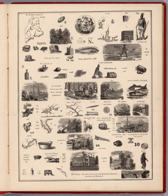
1875 View: Hieroglyphic View of Maine School Atlas (View to) Maine. (to accompany) A Hierog … |

1875 Text Page: Maine School Atlas (Text Page to) Maine. (to accompany) A H … |

1846 Cover: Maps of Maine, New Hampshire and … State Atlas (Covers to) Maps of Maine, New Hampshire … |

1834 Canal de la Chesapeake a l'Ohio. National Atlas Canal de la Chesapeake a l'Ohio. Plan ge … |

1929 Legend: 129-31. Maine, Ohio, Penn., N.Y. … World Atlas (Legend to) Stati Uniti, United States o … |