Who What Where WhenREMOVEWHERE |
REFINE
Browse All : Images of United States from 1805
1-4 of 4
Author
Bradley, Abraham Junior
Full Title
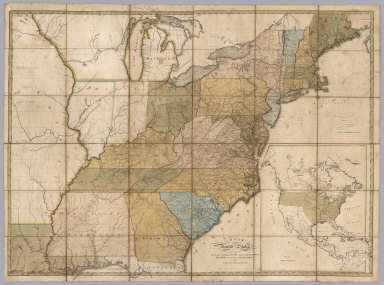
Map of the United States, Exhibiting the Post-Roads, the situations, connexions and distances of the Post-Offices, Stage Roads, Counties & Principal Rivers By Abraham Bradley Junr. Entered ... 2nd day of June1804, by Abraham Bradley Junr. of the District of Columbia. (inset) Map Of North America. (1805)
Publisher
Abraham Bradley
Author
Bradley, Abraham Junior
Full Title
(Covers to) Map of the United States, Exhibiting the Post-Roads, the situations, connexions and distances of the Post-Offices, Stage Roads, Counties & Principal Rivers By Abraham Bradley Junr. Entered ... 2nd day of June1804, by Abraham Bradley Junr. of the District of Columbia. (inset) Map Of North America. (1805)
Publisher
Abraham Bradley
Author
Cary, John, ca. 1754-1835
Full Title
A new map of part of the United States of North America, exhibiting the Western Territory, Kentucky, Pennsylvania, Maryland, Virginia &c., also the lakes Superior, Michigan, Huron, Ontario & Erie; with Upper and Lower Canada &c. From the latest authorities. By John Cary, engraver. 1805. London: Published by J. Cary, Engraver & Map-seller, No. 181, Strand, June 1st, 1805.
Publisher
John Cary
1-4 of 4
|