Browse All

1813 Map of the American Coast, from Lynhaven … National Atlas Map of the American Coast, from Lynhaven … |

1813 Map of the Seat of War in North America. National Atlas Map of the Seat of War in North America. … |

1813 Southern Section of the United States in … National Atlas Southern Section of the United States in … |

1795 Title Page: General Atlas For Carey's Ed … World Atlas (Title Page to) The General Atlas For Ca … |

1796 Map of the United States. World Atlas A Map of the United States: compiled chi … |

1796 Title Page: Carey's general atlas. World Atlas (Title Page to) Carey's General Atlas .. … |

1884 Pennsylvania RR Great Trunk Line. Pocket Map Pennsylvania Railroad Great Trunk Line, … |

1884 Cover: Pocket railroad map Philadelphia. Pocket Map (Covers to) Pocket railroad map and busi … |

1884 Text Page: Pocket railroad map Philadelp … Pocket Map (Text Page to) Pocket railroad map and b … |

1890 United States and territories. Wall Map Map of the United States and territories … |

1905 Vereinigte Staaten von Nordamerika World Atlas Vereinigte Staaten von Nordamerika. Okt. … |

1879 New map of the American Overland Route. [Pocket Map, Timetable Map] New map of the American Overland Route s … |

1905 Nordwestliche Vereinigte Staaten und Sud … World Atlas Nordwestliche Vereinigte Staaten und Sud … |

1905 Sudwestliche Vereinigte Staaten und Nord … World Atlas Sudwestliche Vereinigte Staaten und Nord … |

1905 Sudwestliche Vereinigte Staaten und Nord … World Atlas Nordostliche Vereinigte Staaten und Suos … |

1905 Sudostliche Vereinigte Staaten, Cuba und … World Atlas Sudostliche Vereinigte Staaten, Cuba und … |

1905 Nordoststaaten der nordamerikanischen Un … World Atlas Nordoststaaten der Nordamerikanischen Un … |

1879 Cover: Union and Central Pacific Railroa … [Pocket Map, Timetable Map] (Covers to) Union and Central Pacific Ra … |

1879 Text Page: Union and Central Pacific Rai … [Pocket Map, Timetable Map] (Text Page to) Union and Central Pacific … |

1929 U.S. showing NY Central Lines. Pocket Map Map of the United States showing the New … |

1929 Cover: U.S. showing NY Central Lines. Pocket Map (Covers to) Map of the United States sho … |

1929 Text Page: NY Central Lines. Pocket Map (Text Page to) Map of the United States … |

1907 Text Page: Burlington Route USA map. Timetable Map (Text Page to) Burlington Route. United … |

1885 Cover: Missouri Pacific Ry. Timetable Map (Covers to) Missouri Pacific Ry. ... Ran … |

1885 Text Page: Missouri Pacific Ry. Timetable Map (Text Page to) Missouri Pacific Ry. ... … |

1885 South West Railway System. Timetable Map Map of the South West Railway System. Mi … |

1966 Index Map Physical Atlas Index Map. Locations are Approximate. (i … |

1859 North America. World Atlas Map of North America. 2. Philadelphia, P … |

1859 Canada East (Lower). World Atlas Canada East, formerly Lower Canada. 3. P … |

1859 Canada West (Upper). World Atlas Canada West, formerly Upper Canada. Phil … |

1860 United States. World Atlas A New Map of the United States of Americ … |

1958 United States World Atlas United States. (Copyright) G.P. Ltd. |

1856 Geol. map U.S. Physical Atlas Geological map of the United States and … |

1943 United States World Atlas United States. Copyright, J.W. Clement C … |

1875 Verein-Staaten Von Nord-America, Mexico, … World Atlas Verein-Staaten Von Nord-America, Mexico, … |

1939 Rand McNally Popular map of the United S … World Atlas Rand McNally Popular map of the United S … |

1856 Health, disease. Physical Atlas The geographical distribution of health … |

1875 Vereinigte Staaten Von Nord-Amerika In 6 … World Atlas Vereinigte Staaten Von Nord-Amerika In 6 … |

1940 United States Railroad map National Atlas Rand McNally handy Railroad map United S … |
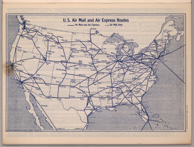
1940 U.S. Air Mail and Air Express Routes National Atlas U.S. Air Mail and Air Express Routes. Co … |

1940 United States Road Map National Atlas Rand McNally Road map, United States. Co … |

1940 Transcontinental Mileage Chart of the Un … National Atlas Rand McNally Transcontinental Mileage Ch … |

1875 Composite: Vereinigten Staaten von Nord- … World Atlas (Composite of) Die Vereinigten Staaten v … |

1855 Vereinigten Staaten von N. America. World Atlas Die Vereinigten Staaten von Nord America … |

1849 Vereinigten Staaten v. N. America. World Atlas Die Vereinigten Staaten von Nord America … |

1863 San Francisco Harbour Surveyed by Lieut. … Chart Map N. America West Coast. San Francisco Har … |
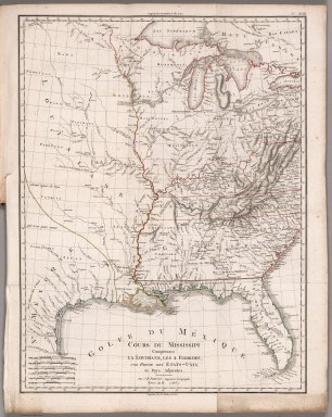
1803 Cours du Mississippi comprenant la Louis … Geography Book Cours du Mississippi comprenant la Louis … |

1932 Plate 2. Physical Geography and Vegetati … [Historical Atlas, National Atlas] Plate 2. Physical Geography and Vegetati … |

1932 Plate 3. Forests. [Historical Atlas, National Atlas] Plate 3. Forests; Growing Season. Area o … |

1932 Plate 4. Climate. [Historical Atlas, National Atlas] Plate 4. Climate. Snow Cover. Droughts. … |