Browse All

1875 Covers: A Hieroglyphic Geography Of The … School Atlas (Covers to) A Hieroglyphic Geography Of … |

1875 Title Page: A Hieroglyphic Geography Of … School Atlas (Title Page to) A Hieroglyphic Geography … |

1875 Text Page: A Hieroglyphic Geography Of T … School Atlas (Text Page to) A Hieroglyphic Geography … |

1875 Text Page: Maine School Atlas (Text Page to) Maine. (to accompany) A H … |
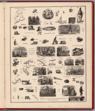
1875 View: Hieroglyphic View of Maine School Atlas (View to) Maine. (to accompany) A Hierog … |

1875 Text Page: Maine School Atlas (Text Page to) Maine. (to accompany) A H … |

1875 Text Page: New Hampshire School Atlas (Text Page to) New Hampshire. (to accomp … |

1875 View: Hieroglyphic View of New Hampshire School Atlas (View to) New Hampshire. (to accompany) … |

1875 Text Page: New Hampshire School Atlas (Text Page to) New Hampshire. (to accomp … |

1875 Text Page: Vermont School Atlas (Text Page to) Vermont. (to accompany) A … |

1875 View: Hieroglyphic View of Vermont School Atlas (View to) Vermont. (to accompany) A Hier … |

1875 Text Page: Vermont School Atlas (Text Page to) Vermont. (to accompany) A … |

1875 Text Page: Massachusetts School Atlas (Text Page to) Massachusetts. (to accomp … |

1861 Cover: United States of North America. Case Map (Covers to) Stanford's New Large-Print M … |

1875 View: Hieroglyphic View of Massachusetts School Atlas (View to) Massachusetts. (to accompany) … |

1875 Text Page:Massachusetts School Atlas (Text Page to) Massachusetts. (to accomp … |

1875 Text Page:Rhode Island School Atlas (Text Page to) Rhode Island. (to accompa … |

1875 View: Hieroglyphic View of Rhode Island School Atlas (View to) Rhode Island. (to accompany) A … |

1875 Text Page: Rhode Island School Atlas (Text Page to) Rhode Island. (to accompa … |

1875 Text Page: Connecticut School Atlas (Text Page to) Connecticut. (to accompan … |

1875 View: Hieroglyphic View of Connecticut School Atlas (View to) Connecticut. (to accompany) A … |

1875 Text Page: Connecticut School Atlas (Text Page to) Connecticut. (to accompan … |

1875 Text Page: New York School Atlas (Text Page to) New York. (to accompany) … |

1875 View: Hieroglyphic View of New York School Atlas (View to) New York. (to accompany) A Hie … |

1875 View: Hieroglyphic View of New York (con … School Atlas (View to) New York (continued). (to acco … |

1875 Text Page: New York School Atlas (Text Page to) New York. (to accompany) … |

1875 Text Page: New York (continued) School Atlas (Text Page to) New York (continued). (to … |

1849 Physical Map Of The United States School Atlas Physical Map Of The United States. Adapt … |

1849 Political Map Of The United States, Mexi … School Atlas Political Map Of The United States, Mexi … |

1849 Physical And Political Map Of The N. Eas … School Atlas Physical And Political Map Of The N. Eas … |

1849 Political Map Of The Northern Division O … School Atlas Political Map Of The Northern Division O … |

1849 Physical & Political Map Of The Southern … School Atlas Physical & Political Map Of The Southern … |

1861 United States Of North America. Case Map Stanford's New Large-Print Map Of The Un … |

1816 United States and Part of Louisiana World Atlas A Map Of The United States and Part of L … |

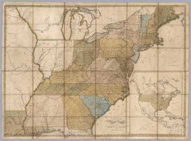
1816 Middle States and Western Territories of … World Atlas The Middle States and Western Territorie … |

1816 The Southern States and Mississippi Terr … World Atlas The Southern States and Mississippi Terr … |

1816 The Northwestern Territories of the Unit … World Atlas The Northwestern Territories of the Unit … |

1890 England. United States. Bolivia. Egypt. World Atlas England. The United States. Bolivia. Egy … |
1805 Map of the United States. Case Map Map of the United States, Exhibiting the … |

1805 Covers: Map of the United States. Case Map (Covers to) Map of the United States, Ex … |

1929 Air Route from Los Angeles to Columbus. Pocket Map (Map of the United States showing the ai … |

1864 Map of the Public Land States And Territ … Separate Map Map of the Public Land States And Territ … |

1929 Illustrated Map of the Route of Transcon … Pocket Map Illustrated Map of the Route of Transcon … |

1885 Texas and Mexico, Houston and Texas Cent … Timetable Map Texas and Mexico showing Houston and Tex … |

1883 Railroad Map Of The United States And Ca … Separate Map New Official Railroad Map Of The United … |

1877 Carte Ecclesiastique Des Etats - Unis D' … Separate Map Carte Ecclesiastique Des Etats - Unis D' … |

1832 Geography Of The United States School Atlas Geography Of The United States--Upon A N … |

1938 Hawaii-Our Greatest Defense Outpost Separate Map Hawaii-Our Greatest Defense Outpost (wit … |

1875 New railroad map of the United States, . … State Atlas New railroad map of the United States, t … |

1875 Population - United States census, 1870. … State Atlas Population - United States census, 1870. … |