Browse All

1876 View: Plate VII. Head of Labyrinth Creek … Exploration Book (View) Plate VII. Head of Labyrinth Cree … |

1876 View: Plate IX. Lower San Juan, Looking … Exploration Book (View) Plate IX. Lower San Juan, Looking … |

1879 Economic map of portions of Wyoming, Ida … Separate Map Economic map of portions of Wyoming, Ida … |

1877 Parts of Western Wyoming, Southeastern I … Separate Map Parts of Western Wyoming, Southeastern I … |

1872 Utah, Arizona, New Mexico, Kansas, Color … [National Atlas, State Atlas] Atlas of the United States, Map of Utah, … |

1870 California, Utah, Nevada, Colorado, New … World Atlas Johnson's California also Utah, Nevada, … |

1874 California, Utah, Nevada, Colorado, New … World Atlas Johnson's California, Utah, Nevada, Colo … |

1875 Utah. [Commercial Reference Book, National Atl Asher & Adams' Utah. Entered according t … |

1873 59. Southwestern Utah. National Atlas Southwestern Utah. Atlas Sheet Number 59 … |

1873 59. Southwestern Utah. National Atlas Southwestern Utah. Atlas Sheet Number 59 … |

1873 59. Southern And Southwestern Utah. National Atlas Southern And Southwestern Utah. Atlas Sh … |

1877 Diurnal force of vapor. Exploration Book Diurnal force of vapor. Pioche, Nev. Ft. … |

1877 (Diurnal) relative humidity. Exploration Book (Diurnal) relative humidity. Georgetown, … |

1877 Diurnal relative humidity. Exploration Book Diurnal relative humidity. Camp Independ … |

1875 Rain sculpture, Salt Creek Canon, Utah. Exploration Book Rain sculpture, Salt Creek Canon, Utah. … |

1875 Rock carved by drifting sand, Grand Wash … Exploration Book Rock carved by drifting sand, near mouth … |

1875 Lava, Lower Sevier, Utah. Exploration Book Lava from valley of Lower Sevier, Utah. … |

1877 XX. Cretaceous. Exploration Book Cretaceous. P. Roetter del. J. Bien lith … |

1909 Oregon & Pacific NW. State Atlas Oregon and the Pacific Northwest. (Publi … |

1909 Utah. State Atlas Utah. (Published by George F. Cram, Chic … |

1875 Utah. National Atlas Cram's Rail Road & Township Map of Utah. … |

1927 Utah. National Atlas Rand McNally junior auto road map Utah. … |

1872 58. Parts Of Eastern And Southern Nevada … National Atlas Parts Of Eastern And Southern Nevada And … |

1872 58. Parts Of Eastern & Southern Nevada A … National Atlas Parts Of Eastern & Southern Nevada And S … |

1873 58, 66. Parts Of E. California, S.E. Nev … National Atlas Atlas Sheet Number 58. Parts Of E. Calif … |

1876 66. Parts Of Eastern & Southeastern Neva … National Atlas Parts Of Eastern & Southeastern Nevada & … |

1872 66. Parts Of Eastern & Southeastern Neva … National Atlas Parts Of Eastern & Southeastern Nevada & … |

1872 49. Parts Of Eastern Nevada And Western … National Atlas Parts Of Eastern Nevada And Western Utah … |

1861 Weber Lower Canyon. Exploration Book Weber Lower Canyon. April 5th at 2 P.M. … |

1861 Second or Sheeprock Canyon of Weber Rive … Exploration Book Second or Sheeprock Canyon of Weber Rive … |

1861 Porcupine Terrace. Exploration Book Porcupine Terrace. Uintah Mountains in t … |

1861 Round Prairie From Head of the Same. Exploration Book Round Prairie From Head of the Same. Apr … |

1861 Goshoot Passage. Exploration Book Goshoot Passage showing 65 miles of the … |

1861 From the Valley of Green River to Great … Exploration Book From the Valley of Green River to the Gr … |

1861 From Great Salt Lake to Humboldt Mountai … Exploration Book From Great Salt Lake to the Humboldt Mou … |

1861 From the Coo-che-to-pa Pass to Wahsatch … Exploration Book From the Coo-che-to-pa Pass to the Wahsa … |

1895 High Plateaus. Exploration Book Scenery on the High Plateaus. H.H. Nicho … |

1895 Tabernacle Crater, lava beds. Exploration Book Tabernacle Crater and lava beds of the B … |

1895 Great Salt Lake Desert. Exploration Book View on Great Salt Lake Desert, showing … |

1895 Pavant Butte. Exploration Book Pavant Butte, over a submarine volcano o … |
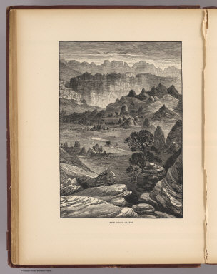
1895 Gray Cliffs. Exploration Book The Gray Cliffs. Nichols. (1895) |

1895 Pink Cliffs, Paunsagunt Plateau. Exploration Book Pink Cliffs, Paunsagunt Plateau. (1895) |

1895 A Permian butte. Exploration Book A Permian butte (Utah? 1895) |

1895 Vermilion Cliffs, Kanab. Exploration Book Vermilion Cliffs at Kanab. (1895) |

1895 Midsummerday's dream on color. Exploration Book A midsummerday's dream on the color (Uta … |

1872 49. Parts Of Eastern Nevada And Western … National Atlas Parts Of Eastern Nevada And Western Utah … |

1895 Hurricane Fault. Exploration Book The Hurricane Fault. (1895) |

1895 Towers, Vermilion Cliffs. Exploration Book Towers of the Vermilion Cliffs. (1895) |

1895 Temples, towers, Rio Virgen. Exploration Book Temples and towers of the Rio Virgen. (1 … |

1895 Green River Station. Exploration Book The start from Green River Station. T(ho … |