Browse All

1780 Essequibo by Siraut - Destouches. National Atlas Siraut - Destouches - [1780?]. Kaart van … |

1791 Coast Region of the Essequibo Colony by … National Atlas Chollet? - 1791 or earlier. S Doc 91 55 … |

1794 Pomeroon Coast Region by Chollet. National Atlas Chollet - 1794. S Doc 91 55 2. 69. Map o … |

1796 Essequibo and Demerara by Bouchenroeder. National Atlas Bouchenroeder - 1796. S Doc 91 55 2. 70. … |

1778 Nueva Andalucia. National Atlas Surville - 1778. S Doc 91 55 2. 71. Mapa … |

1735 Capuchin Missions of Guayana. National Atlas Anonymous - [1735?]. S Doc 91 55 2. 72. … |

1771 Capuchin Missions of Guayana. National Atlas Fr. Carlos de Barcelona - 1771. S Doc 91 … |

1779 Capuchin Missions of Guayana by Carlos d … National Atlas Fr. Carlos de Barcelona - [1779?]. S Doc … |

1789 Capuchin Missions of Guayana. National Atlas Anonymous - [1789?]. S Doc 91 55 2. 75. … |

1560 Early Spanish Map of Guiana. National Atlas Anonymous [15--]. S Doc 91 55 2. 76. Map … |

1827 Apure. National Atlas Carta del Departamento de Apure. Gravado … |

1967 Map Title Page: 224-225. South America, … World Atlas (Map Title Page) 224-225. South America, … |

1967 226. Venezuela, North. The World Atlas. World Atlas 226. Venezuela, North. The World Atlas. |

1865 Venezuela, New Granada and Ecuador. World Atlas Colton's Venezuela, New Granada and Ecua … |

1869 Venezuela, Colombia and Ecuador. World Atlas Colton's Venezuela, United States of Col … |

1875 Venezuela, Colombie, l'Equateur, Guyanes … World Atlas Carte des republiques de l'Equateur, de … |

1897 Colombia, Venezuela. World Atlas Rand, McNally & Co.'s indexed atlas of t … |

1967 South America - Physical. Colombia, Vene … World Atlas South America - Physical. Colombia, Vene … |

1967 Ecuador, Colombia, Venezuela, Guiana. Pe … World Atlas Ecuador, Colombia, Venezuela, Guiana. (i … |

1948 Venezuela. World Atlas Venezuela. 19. |

1860 Map Of New Granada, Venezuela, And Guian … World Atlas Map Of New Granada, Venezuela, And Guian … |

1924 South America (NW Part) National Atlas Commercial Atlas of America. Rand McNall … |

1836 Venezuela, New Grenada & Equador. World Atlas Venezuela, New Grenada & Equador. (with) … |

1884 New Granada, Venezuela, Guiana. World Atlas Map of New Granada, Venezuela and Guiana … |

1857 Venezuela, New Granada (Colombia) and Ec … National Atlas Venezuela, New Granada (Colombia) and Ec … |

1859 Venezuela, New Grenada & Equador. World Atlas Venezuela, New Grenada & Equador. Entere … |

1930 Colombie, Venezuela, Ecuador. World Atlas Colombie, Venezuela, Ecuador. Carte 72. … |

1845 Venezuela, New Grenada & Equador. World Atlas Venezuela, New Grenada & Equador. J. Kni … |

1886 Colombia, Venezuela, Guiana. World Atlas Map of U.S. of Colombia, Venezuela and G … |

1889 South America. National Atlas Rand, McNally & Co.'s South America. (wi … |

1733 A Map of the British Empire in America. … National Atlas A Map of the British Empire in America w … |

1746 A Map of the British Empire in America. … National Atlas A Map of the British Empire in America w … |

1827 Zulia. National Atlas Carta del Departamento del Zulia. Gravad … |

1827 Venezuela. National Atlas Carta del Departamento de Venezuela. Gra … |

1827 Orinoco. National Atlas Carta del Departamento del Orinoco o de … |

1897 Covers: Venezuela-Guyana Boundary; Orino … National Atlas (Covers to) Maps Of The Orinoco-Essequib … |

1897 Half Title Page: Venezuelan Boundary Com … National Atlas (Half Title Page) Venezuelan Boundary Co … |

1897 Title Page: Venezuela-Guyana Boundary; O … National Atlas (Title Page to) Maps Of The Orinoco-Esse … |

1897 Text Page: Introduction. National Atlas (Text Page) Introduction. |

1897 Table of Contents: Contents. National Atlas (Table of Contents) Contents. |
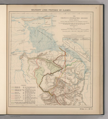
1897 Boundaries Claimed or Proposed. National Atlas Boundary Lines Proposed or Claimed. 1. S … |

1897 Forests and Savannas. National Atlas Forests and Savannas. 2. S Doc 91 55 2. … |

1818 The Caracas. World Atlas A New Map of the Caracas. Warnicke Sc. |

1810 The Caracas. World Atlas The Caracas. Drawn under the direction o … |