|
|
REFINE
Browse All : Images of Washington (D.C.) from 1862
1-3 of 3
Author
U.S. War Department, Topographical Engineers
Full Title
"Surveys For Military Defences" Map Of N. Eastern Virginia And Vicinity Of Washington compiled in Topographical Engineers Office at Division Head Quarters Of General Irvin McDowell Arlington, January 1th 1862 corrected from recent Surveys and Reconnaissances under the direction of the Bureau Of Topographical Engineers August 1st 1862. Drawn By J.J. Young, W. Hesselbach. Engr. On Stone By J. Schedler, No. 120 Pearl St. N.Y. ...
Publisher
J. Schedler
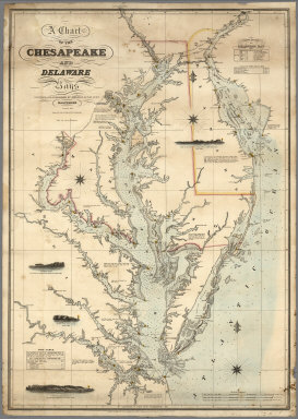
Author
Lucas, Fielding Jr.
Full Title
A Chart of the Chesapeake And Delaware Bays Compiled And Published By Fielding Lucas Junr. Baltimore. Corrected_1862. Engraved by John and William W. Warr Philadelphia. Sold by Lucas Brothers. Drawn by F. Lucas Jr. Entered ... 1852 by Fielding Lucas Jr. ... Maryland.
Publisher
Fielding, Lucas Jr.
1-3 of 3
|