Who What Where WhenREMOVEWHO
WHEN
|
Author
Colton, G.W.
Full Title
Delaware And Maryland. (with) District of Columbia. Published by J.H. Colton & Co. 172 William St. New York. Entered ... 1855 by J.H. Colton & Co. ... New York. No. 22.
Publisher
J.H. Colton
Author
Colton, G.W.
Full Title
Georgetown And The City Of Washington The Capital Of The United States Of America. Entered ... 1855 by J.H. Colton & Co. ... New York. No. 24.
Publisher
J.H. Colton
Author
Morse, Jedidiah
Full Title
Plan of the City of Washington. Published by J. Stockdale, PIccadilly 16th Septr. 1794.
Publisher
John Stockdale
Author
Reid, John
Full Title
Plan of the City of Washington in the Territory of Columbia ceded by the States of Virginia And Maryland to the United States of America and by them established as the Seat of their Government, after the Year 1800. Rollinson sculp. N. York. Published by J. Reid L. Wayland and C. Smith 1795.
Publisher
J. Reid, L. Wayland and C. Smith
Author
Shell Oil Company
Full Title
Shell Map of Metropolitan Washington, D.C. (cover title). Shell Washington D.C. and Vicinity. 12-DD-1956-1. (inset) Alexandria, Virginia.
Publisher
Shell Oil Company
Author
Shell Oil Company
Full Title
Shell Central Washington (D.C.) 12-DD-1956-1. (Verso to) Shell Washington D.C. and Vicinity.
Publisher
Shell Oil Company
Author
Cram, George Franklin
Full Title
Map of Baltimore. Map of Washington (D.C.) Engraved Espressly for the Standard World Atlas. (inset) (Vicinity of Washington D.C.).
Publisher
George F. Cram
Author
Colton, G.W.
Full Title
Colton's Georgetown and the City of Washington the Capital of the United States of America. Published by G. W & C. B. Colton & Co., No. 182 William St. New York.
Publisher
G. W & C. B. Colton & Co.
Author
Colton, G.W.
Full Title
Colton's Georgetown and the City of Washington the Capital of the United States of America. Published by G. W & C. B. Colton & Co., No. 172 William St. New York.
Publisher
G. W & C. B. Colton & Co.
Author
Colton, G.W.
Full Title
Colton's Georgetown and the City of Washington the Capital of the United States of America. Published by G.W. & C.B. Colton & Co., No. 172 William St. New York.
Publisher
G.W. & C.B. Colton
Author
[Jones, T.W., Moore, S.S.]
Full Title
Road from Philadelphia to Washington. (Maps) 21, 22 and 23. Draper, I. Sc.
Publisher
Mathew Carey
Author
New York Herald
Full Title
Map Of The Seat Of War In Virginia. Positions of the Rebel Forces, Batteries, Intrenchments and Encampments in Virginia. The Fortifications for the Protection of Richmond.
Publisher
New York Herald
Author
U.S. War Department, Topographical Engineers
Full Title
"Surveys For Military Defences" Map Of N. Eastern Virginia And Vicinity Of Washington compiled in Topographical Engineers Office at Division Head Quarters Of General Irvin McDowell Arlington, January 1th 1862 corrected from recent Surveys and Reconnaissances under the direction of the Bureau Of Topographical Engineers August 1st 1862. Drawn By J.J. Young, W. Hesselbach. Engr. On Stone By J. Schedler, No. 120 Pearl St. N.Y. ...
Publisher
J. Schedler
Author
Johnson, A.J.
Full Title
Johnson's Georgetown and the City of Washington, the Capital of the United States of America. By Johnson and Ward.
Publisher
Johnson and Ward
Author
Mitchell, Samuel Augustus
Full Title
City of Washington. Published by Thomas, Cowperthwait & Co. Philadelphia. Entered ... 1850 by Thomas, Cowperthwait & Co. ... Pennsylvania. (inset) Plan of principal floor of the Capital.
Publisher
Cowperthwait, Desilver & Butler
Author
[U.S. War Department, Weyss, John E.]
Full Title
Map of the Region between Gettysburg, Pa. and Appomattox Court House, Va. exhibiting the connection between the Campaign And Battle-Field Maps prepared by Authority of the Hon. Secretary of War, under the direction of ... A.A. Humphreys ... N. Michler... Compiled and Drawn by Major John E. Weyss, C. Thompson and J. De la Camp. War Department. Office of the Chief of Engineers. 1869.
Publisher
N.Y. Lithographing, Engraving & Printing Co.
Author
Meyer, Joseph, 1796-1856
Full Title
Plan von Washington. 1845. Aus der Geographischen Graviranstalt des Bibliographischen Instituts zu Hildburghausen, Amsterdam, Paris u. Philadelphia, (1860)
Publisher
Bibliographischen Instituts
Author
[Bradford, Thomas G., Goodrich, S.G.]
Full Title
Washington. Louisville and Jeffersonville. New Orleans. Cincinnati. Entered ... 1838 by T.G. Bradford ... Massachusetts.
Publisher
C.D. Strong
Author
[Dorr, F. W., Rockwell, Cleveland, United States. War Department, Whiting, H. L.]
Full Title
Defenses of Washington. Map of the ground of occupation and defense of the Division of the U.S. Army in Virginia in command of Brig. Gen. Irvin McDowell. U.S. Coast Survey, A.D. Bache, Supdt. Topographical survey by the party in charge of H.L. Whiting, Asst., U.S.C.S. Field work executed during parts of June and July 1861, by F.W. Dorr and C. Rockwell U.S.C.S. (with) Sketch of Paducah, Ky. and vicinity by Captain John Rziha, 19th U.S. Infantry. (with) Sketch of the battle-field of Logan's Cross-roads, Ky. U.S. forces under the command of Brig. Gen. George H. Thomas. Forces of the enemy commanded by General G.B. Crittenden, Jan. 19, 1862. Drawn under the direction of Capt. Michler ... copied by A. Kilp. Sketch of the enemy's fortified position at and opposite Mill Springs, Ky., to which he retreated after his defeat at Logan's Cross-roads by the U.S. forces under Brig. Gen. George H. Thomas, Jan. 19, 1862 ... compiled ... by Edward Ruger ... drawn by A. Kilp ... Julius Bien & Co., Lith., N.Y. (1891-1895)
Publisher
U.S. Government Printing Office
Author
[Hesselbach, W., U.S. War Department, Topographical Engineers, United States. War Department, Young, J. J.]
Full Title
Surveys for military defenses. Map of northeastern Virginia and vicinity of Washington. Sheet 1. Compiled in Topographical Engineers Office at division headquarters of General Irvin McDowell, Arlington, January 1, 1862. Corrected from recent surveys and reconnaissances under direction of the Bureau of Topographical Engineers, August 1, 1862. Drawn by J.J. Young and W. Hesselbach. Julius Bien & Co., Lith., N.Y. (1891-1895)
Publisher
U.S. Government Printing Office
Author
United States. War Dept. Engineer Bureau
Full Title
Defenses of Washington. Extract of military map of N.E. Virginia, showing forts and roads. Engineer Bureau, War Department, 1865. Map of the city of Richmond, Va. From a survey by I.H. Adams, Assist. U.S. Coast Survey, 1858. With additions from Smith's map of Henrico County, 1853. Prepared at the U.S. Coast Survey office, A.D. Bache, Supt., 1864. Julius Bien & Co., Lith., N.Y. (1891-1895)
Publisher
U.S. Government Printing Office
Author
Johnson, A.J.
Full Title
Johnson's Washington (D.C.) and Georgetown. Published by A. J. Johnson, New York. Johnson's Delaware and Maryland. Published by A. J. Johnson, New York. 48. Entered according to the Act of Congress, in the year 1868, by A.J. Johnson in the Clerk's Office of the District Court of the United States for the Southern District of New York.
Publisher
A.J. Johnson.
Author
[Bourquin, Frederick, Mitchell, Samuel Augustus, Tanner, Henry S.]
Full Title
City of Washington. Published by S. Augustus Mitchell, N.E. Corner of Market & 7th. Streets Philada. Entered according to Act of Congress in the 1846 by H.N. Burroughs - in the Clerk's Office of the Eastern District of Pennsylvania. 16.
Publisher
S. Augustus Mitchell.
Author
Asher & Adams
Full Title
Asher & Adams' Delaware, Maryland, Virginia, West Virginia & District of Columbia. Entered according to Act of Congress 1874 by Asher & Adams in the Office of the Librarian of Congress at Washington.
Publisher
Asher & Adams.
Full Title
Carte geographique, statistique et historique du District de Colombie. District de Colombie. Fonderie et Imprimerie de J. Carez. (1825)
Publisher
J. Carez
Author
Fullarton, A. & Co.
Full Title
Southern Ports & Harbours in the United States. By J. Bartholomew, F.R.G.S. (with) eight maps. LXa. A. Fullarton & Co. London and Edinburgh.
Publisher
A. Fullarton & Co.
Author
Klinckowstrom, Axel Leonhard
Full Title
Flyglarna af capitolen i Washington ar 1819. (Stockholm: Stente af C. Muller, 1824)
Publisher
C. Muller
Author
Klinckowstrom, Axel Leonhard
Full Title
Title Page to: Atlas til Friherre Klinckowstroms Bref om de Forente Staterne. (Stockholm) Stente af C. Muller, (1824)
Publisher
C. Muller
Author
Marshall, John
Full Title
Vue de la Ville de Washington, en 1800. (1807)
Publisher
Dentu, Imprimeur-Libraire.
Author
Colton, G.W.
Full Title
Delaware and Maryland. No. 22. Published by J.H. Colton & Co., No 172 William St., New York. Entered according to the Act of Congress in the year 1855 by J.H. Colton & Co. in the Clerk's Office of the District Court of the United States for the Southern District of New York.
Publisher
J.H. Colton
Author
Colton, G.W.
Full Title
Georgetown and the City of Washington, the Capital of the United States of America. No. 24. Published by J.H. Colton & Co., No 172 William St., New York. Entered according to the Act of Congress in the year 1855 by J.H. Colton & Co. in the Clerk's Office of the District Court of the United States for the Southern District of New York.
Publisher
J.H. Colton
Author
National Engraving Co.
Full Title
Views in the nation's capital, Washington, D.C. National Engraving Co., Washington, D.C. (Published by Ellis A. Davis. Berkeley, Cal. Seattle. 1909)
Publisher
E.A. Davis
Author
Bradford, Thomas G.
Full Title
Washington. Louisville and Jeffersonville. New Orleans. Cincinnati. Entered ... 1838, by T.G. Bradford ... Massachusetts.
Publisher
[Weeks, Jordan & Co., Wiley and Putnam.]
Author
Mitchell, Samuel Augustus
Full Title
City of Washington. Published By S. Augustus Mitchell. N.E. corner of Market & 7th. Streets. Philada. (inset) Plan of the principal floor of Capital.
Publisher
S.A. Mitchell
Author
Mitchell, Samuel Augustus Jr.
Full Title
Plan of the city of Washington. The capitol of the United States of America. Entered ... 1877 by S. Augustus Mitchell, . ... Washington.
Publisher
S.A. Mitchell Jr.
Author
Mitchell, Samuel Augustus
Full Title
City of Washington. Published by Charles Desilver. Entered ... 1856 by Charles Desilver ... Pennsylvania. (inset) Plan of the Principal floor of the Capital.
Publisher
Charles DeSilver
Author
[Gray, Ormando Willis, Lloyd, H.H., Martenet, Simon J., Walling, H. F.]
Full Title
(Covers to) New topographical atlas of the State of Maryland and the District of Columbia. With descriptions historical, scientific, and statistical, together with maps of the United States and Territories. By S.J. Martenet, H.F. Walling, and O.W. Gray, civil and topographical engineers. Published by Stedman, Brown & Lyon, Baltimore. 1873. (on verso ot title page) Entered ... 1872, by H.F. Walling, and O.W. Gray, and Simon J. Martenet ... Washington.
Publisher
Stedman, Brown & Lyon
Author
[Gray, Ormando Willis, Lloyd, H.H., Martenet, Simon J., Walling, H. F.]
Full Title
(Title Page to) New topographical atlas of the State of Maryland and the District of Columbia. With descriptions historical, scientific, and statistical, together with maps of the United States and Territories. By S.J. Martenet, H.F. Walling, and O.W. Gray, civil and topographical engineers. Published by Stedman, Brown & Lyon, Baltimore. 1873. (on verso) Entered ... 1872, by H.F. Walling, and O.W. Gray, and Simon J. Martenet ... Washington.
Publisher
Stedman, Brown & Lyon
Author
[Gray, Ormando Willis, Lloyd, H.H., Martenet, Simon J., Walling, H. F.]
Full Title
(Contents to) New topographical atlas of the State of Maryland and the District of Columbia. With descriptions historical, scientific, and statistical, together with maps of the United States and Territories. By S.J. Martenet, H.F. Walling, and O.W. Gray, civil and topographical engineers. Published by Stedman, Brown & Lyon, Baltimore. 1873. (on verso) Entered ... 1872, by H.F. Walling, and O.W. Gray, and Simon J. Martenet ... Washington.
Publisher
Stedman, Brown & Lyon
Author
Tyson, Philip T.
Full Title
Map of Maryland and the District of Columbia, colored to illustrate the geological formations by Philip T. Tyson. L.E. Neuman, eng. , 36 Vesey St., N.Y. (Published by Stedman, Brown & Lyon, Baltimore. 1873)
Publisher
Stedman, Brown & Lyon
Author
Blodget, Lorin
Full Title
Climatological map of the State of Maryland and the District of Columbia, by Lorin Blodget, 1873. (Published by Stedman, Brown & Lyon, Baltimore. 1873)
Publisher
Stedman, Brown & Lyon
Author
Gray, Frank Arnold
Full Title
New railroad map of the states of Maryland, Delaware, and the District of Columbia. Compiled and drawn by Frank Arnold Gray, 1873. (Published by Stedman, Brown & Lyon, Baltimore. 1873)
Publisher
Stedman, Brown & Lyon
Author
[Gray, Ormando Willis, Martenet, Simon J., Walling, H. F.]
Full Title
Topographical atlas of Maryland: counties of Howard and Montgomery and the District of Columbia. (Published by Stedman, Brown & Lyon, Baltimore. 1873)
Publisher
Stedman, Brown & Lyon
Author
[Gray, Ormando Willis, Martenet, Simon J., Walling, H. F.]
Full Title
Map of the District of Columbia including the cities of Washington, Georgetown, and Alexandria, Virginia. 1873. (Published by Stedman, Brown & Lyon, Baltimore. 1873)
Publisher
Stedman, Brown & Lyon
Full Title
Plan of the city of Washington. The capitol of the United States of America. Drawn and engraved by W.H. Gamble. (Copyright 1887 by Wm. M. Bradley & Bro. 1890)
Publisher
John Y. Huber & Co.
Author
Mitchell, Samuel Augustus
Full Title
Plan of the city of Washington, the capitol of the United States of America. Drawn and engraved by W.H. Gamble. Entered ... 1870 by S. Augustus Mitchell, Jr. ... Pennsylvania.
Publisher
[R.A. Campbell, S.A. Mitchell, Jr.]
Author
Mitchell, Samuel Augustus
Full Title
Plan of the city of Washington. The capitol of the United States of America. Drawn and engraved by W.H. Gamble. Entered ... 1879 by S. Augustus Mitchell ... Washington. (1880)
Publisher
S.A. Mitchell
Author
Mitchell, Samuel Augustus
Full Title
City of Washington. Published By Charles Desilver, No. 714 Chesnut Street. Entered according to Act of Congress in the year 1859 by Charles Desilver in the Clerk's office if the District Court of the Eastern District of Pennsylvania. 16.
Publisher
Charles Desilver.
Author
[Rand McNally and Company, State Farm Insurance Companies Travel Bureau]
Full Title
City maps. Washington, D.C. Copyright by Rand McNally & Company, Chicago, Ill. Lithographed in the U.S.A. (with two inset maps) San Antonio, Tex., and Toledo, Ohio. (to accompany) State Farm Road Atlas: United States, Canada, Mexico,Central and South America. Copyright 1940 by Rand McNally & Company, Chicago, Ill.
Publisher
State Farm Insurance Companies Travel Bureau
Author
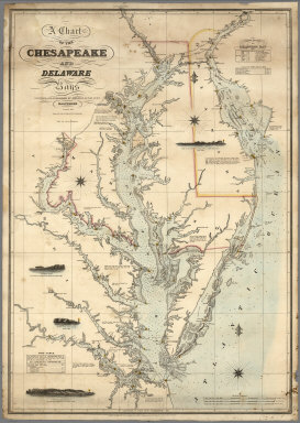
Lucas, Fielding Jr.
Full Title
A Chart of the Chesapeake And Delaware Bays Compiled And Published By Fielding Lucas Junr. Baltimore. Corrected_1862. Engraved by John and William W. Warr Philadelphia. Sold by Lucas Brothers. Drawn by F. Lucas Jr. Entered ... 1852 by Fielding Lucas Jr. ... Maryland.
Publisher
Fielding, Lucas Jr.
|