Who What Where WhenREMOVEWHO
WHEN
|
Author
Melish, John
Full Title
(Covers to) A New Juvenile Atlas, And Familiar Introduction To The Use Of Maps: With A Comprehensive View Of The Present State Of The Earth ... First American From The Latest London Edition, Corrected And Improved, By John Melish. Philadelphia, Printed For John Melish, John Vallance, And H.S. Tanner, No. 209, Chestnut-Street, By G. Palmer. 1814.
Publisher
G. Palmer
Author
Melish, John
Full Title
(Title Page to) A New Juvenile Atlas, And Familiar Introduction To The Use Of Maps: With A Comprehensive View Of The Present State Of The Earth ... First American From The Latest London Edition, Corrected And Improved, By John Melish. Philadelphia, Printed For John Melish, John Vallance, And H.S. Tanner, No. 209, Chestnut-Street, By G. Palmer. 1814.
Publisher
G. Palmer
Author
Melish, John
Full Title
(Advertisement to) A New Juvenile Atlas, And Familiar Introduction To The Use Of Maps: With A Comprehensive View Of The Present State Of The Earth ... First American From The Latest London Edition, Corrected And Improved, By John Melish. Philadelphia, Printed For John Melish, John Vallance, And H.S. Tanner, No. 209, Chestnut-Street, By G. Palmer. 1814.
Publisher
G. Palmer
Author
Melish, John
Full Title
Elementary Map. (engraved by) H.S. Tanner. Sc. Published ... 1814 by J. Melish. J. Vallance & H.S. Tanner. Philadelphia. (to accompany) A New Juvenile Atlas, And Familiar Introduction To The Use Of Maps: With A Comprehensive View Of The Present State Of The Earth ... First American From The Latest London Edition, Corrected And Improved, By John Melish. Philadelphia, Printed For John Melish, John Vallance, And H.S. Tanner, No. 209, Chestnut-Street, By G. Palmer. 1814.
Publisher
G. Palmer
Author
Melish, John
Full Title
(Text Page to) Elementary Definitions, &c. (accompany to) Elementary Map. (engraved by) H.S. Tanner. Sc. Published ... 1814 by J. Melish. J. Vallance & H.S. Tanner. Philadelphia. (to accompany) A New Juvenile Atlas, And Familiar Introduction To The Use Of Maps: With A Comprehensive View Of The Present State Of The Earth ... First American From The Latest London Edition, Corrected And Improved, By John Melish. Philadelphia, Printed For John Melish, John Vallance, And H.S. Tanner, No. 209, Chestnut-Street, By G. Palmer. 1814.
Publisher
G. Palmer
Author
Melish, John
Full Title
(Text Page to) Description Of Maps. Of Maps In General. (to accompany) A New Juvenile Atlas, And Familiar Introduction To The Use Of Maps: With A Comprehensive View Of The Present State Of The Earth ... First American From The Latest London Edition, Corrected And Improved, By John Melish. Philadelphia, Printed For John Melish, John Vallance, And H.S. Tanner, No. 209, Chestnut-Street, By G. Palmer. 1814.
Publisher
G. Palmer
Author
Melish, John
Full Title
The World. On Mercator's Projection; With All The Latest Discoveries. (engraved by) H.S. Tanner. Sc. Published ... 1814 by J. Melish. J. Vallance & H.S. Tanner. Philadelphia. Map showing: "To find the Distance Of One Place From another." (to accompany) A New Juvenile Atlas, And Familiar Introduction To The Use Of Maps: With A Comprehensive View Of The Present State Of The Earth ... First American From The Latest London Edition, Corrected And Improved, By John Melish. Philadelphia, Printed For John Melish, John Vallance, And H.S. Tanner, No. 209, Chestnut-Street, By G. Palmer. 1814.
Publisher
G. Palmer
Author
Melish, John
Full Title
(Text Page to) Of The World In General. (to accompany) A New Juvenile Atlas, And Familiar Introduction To The Use Of Maps: With A Comprehensive View Of The Present State Of The Earth ... First American From The Latest London Edition, Corrected And Improved, By John Melish. Philadelphia, Printed For John Melish, John Vallance, And H.S. Tanner, No. 209, Chestnut-Street, By G. Palmer. 1814.
Publisher
G. Palmer
Author
Melish, John
Full Title
(Text Page to) Of America. (to accompany) A New Juvenile Atlas, And Familiar Introduction To The Use Of Maps: With A Comprehensive View Of The Present State Of The Earth ... First American From The Latest London Edition, Corrected And Improved, By John Melish. Philadelphia, Printed For John Melish, John Vallance, And H.S. Tanner, No. 209, Chestnut-Street, By G. Palmer. 1814.
Publisher
G. Palmer
Author
Melish, John
Full Title
(Index Page to) Table Of The Principal Places In The World, With Their Latitudes and Longitudes From London. (to accompany) A New Juvenile Atlas, And Familiar Introduction To The Use Of Maps: With A Comprehensive View Of The Present State Of The Earth ... First American From The Latest London Edition, Corrected And Improved, By John Melish. Philadelphia, Printed For John Melish, John Vallance, And H.S. Tanner, No. 209, Chestnut-Street, By G. Palmer. 1814.
Publisher
G. Palmer
Author
Melish, John
Full Title
(Index Page to) List Of Post Towns. (and) Useful Geographical Tables, Designed Principally For Young Persons. (to accompany) A New Juvenile Atlas, And Familiar Introduction To The Use Of Maps: With A Comprehensive View Of The Present State Of The Earth ... First American From The Latest London Edition, Corrected And Improved, By John Melish. Philadelphia, Printed For John Melish, John Vallance, And H.S. Tanner, No. 209, Chestnut-Street, By G. Palmer. 1814.
Publisher
G. Palmer
Author
Melish, John
Full Title
(Index Page to) Geographical Tables. (to accompany) A New Juvenile Atlas, And Familiar Introduction To The Use Of Maps: With A Comprehensive View Of The Present State Of The Earth ... First American From The Latest London Edition, Corrected And Improved, By John Melish. Philadelphia, Printed For John Melish, John Vallance, And H.S. Tanner, No. 209, Chestnut-Street, By G. Palmer. 1814.
Publisher
G. Palmer
Author
Woodbridge, William C.
Full Title
(Covers to) Modern Atlas On A New Plan; To Accompany The System Of Universal Geography, By William Channing Woodbridge. Exhibiting In Connexion With The Outlines Of Countries, The Prevailing Religions, Forms Of Government, And Degrees Of Civilization; The Comparative Size Of Towns, Rivers And Mountains, And The Climates and Productions of the Earth ... London: Published For The Proprietors, By Geo. B. Whittaker, Ave-Maria-Lane. 1828. (on verso) London: Printed By Thomas Davison, Whitefriars.
Publisher
Geo. B. Whittaker
Author
Woodbridge, William C.
Full Title
(Title page to) Modern Atlas On A New Plan; To Accompany The System Of Universal Geography, By William Channing Woodbridge. Exhibiting In Connexion With The Outlines Of Countries, The Prevailing Religions, Forms Of Government, And Degrees Of Civilization; The Comparative Size Of Towns, Rivers And Mountains, And The Climates and Productions of the Earth ... London: Published For The Proprietors, By Geo. B. Whittaker, Ave-Maria-Lane. 1828. (on verso) London: Printed By Thomas Davison, Whitefriars.
Publisher
Geo. B. Whittaker
Author
Woodbridge, William C.
Full Title
The World. Published by Wittaker & Arnot, 13 Ave-Maria-Lane, London. (to accompany) Modern Atlas On A New Plan; To Accompany The System Of Universal Geography, By William Channing Woodbridge. Map showing the Comparative View of Rivers and Lakes on the Western and Eastern Continents. Two insets explain circles, zones, parallels, and meridians.
Publisher
Geo. B. Whittaker
Author
Woodbridge, William C.
Full Title
Moral And Political Chart Of The World. Exhibiting the Prevailing Religion, Governement Degree Of Civilization, And Number of Inhabitants Of Each Country. By W.C. Woodbridge. Published by Wittaker & Arnot, 13 Ave-Maria-Lane, London. (to accompany) Modern Atlas On A New Plan; To Accompany The System Of Universal Geography, By William Channing Woodbridge. (inset) Distribution of Mankind With Their Races & Religions. (inset) Key To The Emblems.
Publisher
Geo. B. Whittaker
Author
Woodbridge, William C.
Full Title
Isothermal Chart Or View Of the Climates & Productions of The Earth. By W.C. Woodbridge. Perkins & Heath, London. Published by Wittaker & Arnot, 13 Ave-Maria-Lane, London. (to accompany) Modern Atlas On A New Plan; To Accompany The System Of Universal Geography, By William Channing Woodbridge. Includes Explanation: "The Figures upon the Chart indicate the means Annual temperature of the places... The dotted lines crossing the Chart point out to places which have equal degree of heat. These form the boundaries of regions distinguished by color... The numbers in fractions indicate the temperature in summer and Winter. "
Publisher
Geo. B. Whittaker
Author
Woodbridge, William C.
Full Title
(Covers to) Woodbridge's Larger Atlas. Atlas On A New Plan, Exhibiting The Prevailing Religions, Forms Of Government, Degrees Of Civilization, And The Comparative Size Of Towns, Rivers And Mountains. By William C. Woodbridge, A.M. ... Hartford: Published by Samuel G. Goodrich ... District Of Connecticut, ss. Be It Remembered, That on the twentieth day of April, in the forty-sixth year of the Independence of the United States of America, William C. Woodbridge ... and Emma Willard ... deposited in this Office the title of a Book ... Chas. A. Ingersoll, Clerk of the District of Connecticut.
Publisher
Samuel G. Goodrich
Author
Woodbridge, William C.
Full Title
The World. Entered ... 1821, by William C. Woodbridge ... Cunnecticut. (to accompany) Woodbridge's Larger Atlas. Atlas On A New Plan, Exhibiting The Prevailing Religions, Forms Of Government, Degrees Of Civilization, And The Comparative Size Of Towns, Rivers And Mountains. By William C. Woodbridge, A.M. ... Hartford: Published by Samuel G. Goodrich ...
Publisher
Samuel G. Goodrich
Author
Woodbridge, William C.
Full Title
Chart Of the Inhabited World; Exhibiting The Prevailing Religion, Form Of Government, Degree Of Civilization & Population Of Each Country. Entered ... 1821, by William C. Woodbridge ... Cunnecticut. ( to accompany) Woodbridge's Larger Atlas. Atlas On A New Plan, Exhibiting The Prevailing Religions, Forms Of Government, Degrees Of Civilization, And The Comparative Size Of Towns, Rivers And Mountains. By William C. Woodbridge, A.M. ... Hartford: Published by Samuel G. Goodrich ...
Publisher
Samuel G. Goodrich
Author
Willard, Emma
Full Title
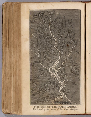
Progress Of The Roman Empire, Illustrated By The course Of The River Amazon. (Accompany) A System of Universal Geography, On The Principles of Comparison and Classification; By William Channing Woodbridge ... Illustrated With Maps and Engravings; And Accompanied by an Atlas ... (with) Ancient Geography, As Connected With Chronology, And Preparatory to the Study of Ancient History: By Emma Willard ... Hartford: Oliver D. Cooke & Sons. 1824. (on verso) ... on the eleventh day of June ... (1824) ... William C. Woodbridge ... and Emma Willard ... have deposited ... a Book ... Connecticut.
Publisher
Oliver D. Cooke & Sons
Author
Willard, Emma
Full Title
The Ancient World According to Strabo. (Accompany) Ancient Geography, As Connected With Chronology, And Preparatory to the Study of Ancient History: By Emma Willard ... Hartford: Oliver D. Cooke & Sons. 1824. (on verso) ... on the eleventh day of June ... (1824). (with) A System of Universal Geography, On The Principles of Comparison and Classification; By William Channing Woodbridge ... Illustrated With Maps and Engravings; And Accompanied by an Atlas ... William C. Woodbridge ... and Emma Willard ... have deposited ... a Book ... Connecticut.
Publisher
Oliver D. Cooke & Sons
Author
Willard, Emma
Full Title
Map No. 1. Countries Known To The Ancients. So Arranged as to Show by the Characters & Colours Used during Which of the Six Epocha's into Which Ancient Time is Divided, Each Century Become Known. Entered according to act of Congress 5th. Day of September 1827 by Oliver D. Cooke & Co. of the State of Connecticut.
Publisher
Belknap and Hamersley
Author
Willard, Emma
Full Title
Map No. II. The World As Known To The Ancients. The Modern Name of Places Inserted on this Map... Placed under the Ancient names... Entered according to act of Congress 5th. Day of September 1827 by Oliver D. Cooke & Co. of the State of Connecticut.
Publisher
Belknap and Hamersley
Author
Willard, Emma
Full Title
Map No. VI. Migrations, Settlements &c Of Barbarous Tribes. Illustrating the Account which is given to Them in Willard's Ancient Geography. (arrow on the map) Shows the direction of the Wondering Tribes. Entered according to act of Congress 5th. Day of September 1827 by Oliver D. Cooke & Co. of the State of Connecticut.
Publisher
Belknap and Hamersley
Author
Page, H.R. & Co.
Full Title
Map of the World.
Publisher
H.R. Page & Co.
Author
Woodbridge, William C.
Full Title
Map Of The World. Adapted To Woodbridge's Geography. Exhibiting The Eastern & Western Hemisphere, And the Land Hemisphere, Together With Comparative View Of the Rivers And Lake of the Two Continents. Includes 2 insets and Comparative View of Rivers & Lakes on The Eastern and Western Continents. Entered ... 1845, by W.C. Woodbridge ... Massachusetts. Hartford. Published By Wm. Jas. Hamersley. (to accompany) Modern Atlas, Physical, Political And Statistical; Exhibiting On Separate Maps ... Entered ... 1843, by W.C. Woodbridge ... Massachusetts. Hartford. Published By Belknap And Hamersley.
Publisher
Belknap and Hamersley
Author
Woodbridge, William C.
Full Title
Moral And Political Chart Of the Inhabited World. Exhibiting The Prevailing Religions, Forms Of Government And Degrees Of Civilization, And Population Of Each Country. By W.C. Woodbrige. Entered ... 1845, by W.C. Woodbridge ... Massachusetts. Hartford. Published By Wm. Jas. Hamersley. (inset map) Central Europe. (inset untitled map) showing Polynesia and Australia. (to accompany) Modern Atlas, Physical, Political And Statistical; Exhibiting On Separate Maps ... Entered ... 1843, by W.C. Woodbridge ... Massachusetts. Hartford. Published By Belknap And Hamersley.
Publisher
Belknap and Hamersley
Author
Woodbridge, William C.
Full Title
Isothermal Chart Or View Of Climates: Showing also The Situations Of The Principal Plants & Animals Of The World. By W.C. Woodbridge. (to accompany) Modern Atlas, Physical, Political And Statistical; Exhibiting On Separate Maps ... Entered .. . 1843, by W.C. Woodbridge ... Massachusetts. Hartford. Published By Wm. Jas. Hamersley. (inset map) Animals of New Holland.
Publisher
Belknap and Hamersley
Author
Johnson, A.J.
Full Title
(Covers to) Johnson's New Illustrated Family Atlas Of The World, Was Awarded The First Prize Medal At The Universal Exposition Of 1867, In Paris, With A Treatise On Physical Geography, By A. Guyot, LL.D. ... With Descriptions, Geographical, Statistical, And Historical ... A Dictionary Of Religious Denominations, Sects, Parties, And Associations, Compiled By Professor Roswell D. Hitchcock, D.D. ... New York: A.J. Johnson, Publisher, 276 & 278 Mulberry Street. 1870. Entered ... One Thousand Eight Hundred and Seventy, by A.J. Johnson ... New York.
Publisher
A.J. Johnson
Author
Johnson, A.J.
Full Title
(Frontispiece) United States Capital. Engraved upon Steel by C.E. Loven. Entered .. 1886. From a Photograph of the Drawings by T.U. Walter, Architect, Washington D.C.
Publisher
A.J. Johnson
Author
Johnson, A.J.
Full Title
(Title Page to) Johnson's New Illustrated Family Atlas Of The World, Was Awarded The First Prize Medal At The Universal Exposition Of 1867, In Paris, With A Treatise On Physical Geography, By A. Guyot, LL.D. ... With Descriptions, Geographical, Statistical, And Historical ... A Dictionary Of Religious Denominations, Sects, Parties, And Associations, Compiled By Professor Roswell D. Hitchcock, D.D. ... New York: A.J. Johnson, Publisher, 276 & 278 Mulberry Street. 1870. Entered ... One Thousand Eight Hundred and Seventy, by A.J. Johnson ... New York.
Publisher
A.J. Johnson
Author
Johnson, A.J.
Full Title
(Table of Contents to) Johnson's New Illustrated Family Atlas Of The World, Was Awarded The First Prize Medal At The Universal Exposition Of 1867, In Paris, With A Treatise On Physical Geography, By A. Guyot, LL.D. ... With Descriptions, Geographical, Statistical, And Historical ... A Dictionary Of Religious Denominations, Sects, Parties, And Associations, Compiled By Professor Roswell D. Hitchcock, D.D. ... New York: A.J. Johnson, Publisher, 276 & 278 Mulberry Street. 1870. Entered ... One Thousand Eight Hundred and Seventy, by A.J. Johnson ... New York.
Publisher
A.J. Johnson
Author
Johnson, A.J.
Full Title
(Alphabetical Table of Contents to) Johnson's New Illustrated Family Atlas Of The World, Was Awarded The First Prize Medal At The Universal Exposition Of 1867, In Paris, With A Treatise On Physical Geography, By A. Guyot, LL.D. ... With Descriptions, Geographical, Statistical, And Historical ... A Dictionary Of Religious Denominations, Sects, Parties, And Associations, Compiled By Professor Roswell D. Hitchcock, D.D. ... New York: A.J. Johnson, Publisher, 276 & 278 Mulberry Street. 1870. Entered ... One Thousand Eight Hundred and Seventy, by A.J. Johnson ... New York.
Publisher
A.J. Johnson
Author
Johnson, A.J.
Full Title
A Diagram, Exhibiting the difference of time between the places shown & Washington.
Publisher
A.J. Johnson
Author
Johnson, A.J.
Full Title
Johnson's New Chart of National Emblems. Entered ... 1869.
Publisher
A.J. Johnson
Author
Johnson, A.J.
Full Title
Johnson's Chart of Comparative Heights of Mountains, and Lengths of Rivers of Africa ... Asia ... Europe ... South America ... North America. Entered ... 1864.
Publisher
A.J. Johnson
Author
Guyot, A.
Full Title
Johnson's Physical Map, Showing the Principal Mountains, Plateaus & Plains of the World. By Prof. A. Guyot. Published by A.J. Johnson, New York. Entered ... 1870.
Publisher
A.J. Johnson
Author
Guyot, A.
Full Title
Johnson's World Showing the Lines of Equal Magnetic Declination ... the Course of Tidal-Waves in the Three Great Oceans and the Distribution of Volcanoes ... Distribution of the Principal Races of Man. By Prof. A. Guyot. Entered ... 1870.
Publisher
A.J. Johnson
Author
Guyot, A.
Full Title
Johnson's Ocean Currents and the Great River Basins of the World. Entered ... 1870.Johnson's World Showing the Distribution of the Temperature of the Air. Entered ... 1870.
Publisher
A.J. Johnson
Author
Guyot, A.
Full Title
Johnson's World, Showing the Circulation of the Winds, and the Course of Storms. Entered ... 1870. Johnson's World Showing the Distribution of the Rain over the Globe. Entered ... 1870.
Publisher
A.J. Johnson
Author
Guyot, A.
Full Title
Johnson's World, Showing the Distribution of the Characteristic Forest Trees, Principal Useful Plants and Minerals. Entered ... 1870.
Publisher
A.J. Johnson
Author
Johnson, A.J.
Full Title
Coats of Arms. Entered ... 1863.
Publisher
A.J. Johnson
Author
Johnson, A.J.
Full Title
Johnson's Globular World. Western Hemisphere. Eastern Hemisphere. Entered ... 1867.
Publisher
A.J. Johnson
Author
Johnson, A.J.
Full Title
Johnson's World on Mercators Projection. Entered ... 1865.
Publisher
A.J. Johnson
Author
Vancouver, George, 1757-1798
Full Title
(Covers to) A Voyage Of Discovery To The North Pacific Ocean And Round The World In Which The Coast of North-West America Has Been Carefully Examined And Accurately Surveyed. Undertaken by His Majesty's Command, Principally With A View To Ascertain The Existence Of Any Navigable Communication Between The North Pacific and North Atlantic Oceans; And Performed In The Years 1790, 1791, 1792, 1793, 1794, and 1795 In The Discovery Sloop Of War, And Armed Tender Chatham, Under The Command Of Captain George Vancouver. In Three Volumes. London: Printed For G.G. And J. Robinson, Paternoster-Row; And J. Edwards, Pall-Mall. 1798.
Publisher
G.G. & J. Robinson
Author
Marzolla, Benedetto
Full Title
Carta generale del mondo conosciuto dagli antichi. Napoli 1843. Reale Litografia Militare, Benedetto Marzolla, impiegato nel Rle. Officio Topografico esgui col pennello su pietra.
Publisher
B. Marzolla
|