Who What Where WhenREMOVEWHO
WHEN
|
Author
Stanford, Edward
Full Title
(Covers to) Stanford's London atlas of universal geography exhibiting the physical and political divisions of the various countries of the world. Folio edition. One hundred maps, with a list of latitudes and longitudes. Second issue, revised and enlarged. London, Edward Stanford, Geographer to Her Majesty, 12, 13 & 14 Long Acre, W.C. 1901.
Publisher
Edward Stanford
Author
Stanford, Edward
Full Title
(Half Title Page to) Stanford's London atlas of universal geography exhibiting the physical and political divisions of the various countries of the world. Folio edition. One hundred maps, with a list of latitudes and longitudes. Second issue, revised and enlarged. London, Edward Stanford, Geographer to Her Majesty, 12, 13 & 14 Long Acre, W.C. 1901.
Publisher
Edward Stanford
Author
Stanford, Edward
Full Title
(Title Page to) Stanford's London atlas of universal geography exhibiting the physical and political divisions of the various countries of the world. Folio edition. One hundred maps, with a list of latitudes and longitudes. Second issue, revised and enlarged. London, Edward Stanford, Geographer to Her Majesty, 12, 13 & 14 Long Acre, W.C. 1901.
Publisher
Edward Stanford
Author
Stanford, Edward
Full Title
(Dedication Page to) Stanford's London atlas of universal geography exhibiting the physical and political divisions of the various countries of the world. Folio edition. One hundred maps, with a list of latitudes and longitudes. Second issue, revised and enlarged. London, Edward Stanford, Geographer to Her Majesty, 12, 13 & 14 Long Acre, W.C. 1901.
Publisher
Edward Stanford
Author
Stanford, Edward
Full Title
(Preface to) Stanford's London atlas of universal geography exhibiting the physical and political divisions of the various countries of the world. Folio edition. One hundred maps, with a list of latitudes and longitudes. Second issue, revised and enlarged. London, Edward Stanford, Geographer to Her Majesty, 12, 13 & 14 Long Acre, W.C. 1901.
Publisher
Edward Stanford
Author
Stanford, Edward
Full Title
(Contents to) Stanford's London atlas of universal geography exhibiting the physical and political divisions of the various countries of the world. Folio edition. One hundred maps, with a list of latitudes and longitudes. Second issue, revised and enlarged. London, Edward Stanford, Geographer to Her Majesty, 12, 13 & 14 Long Acre, W.C. 1901.
Publisher
Edward Stanford
Author
Stanford, Edward
Full Title
(Preface to) Stanford's London atlas of universal geography exhibiting the physical and political divisions of the various countries of the world. Folio edition. One hundred maps, with a list of latitudes and longitudes. Second issue, revised and enlarged. London, Edward Stanford, Geographer to Her Majesty, 12, 13 & 14 Long Acre, W.C. 1901.
Publisher
Edward Stanford
Author
Hotan, 1654-1738
Full Title
Nanzenbushu bankoku shoka no zu. Rokashi. Hoei 7 (1710)
Publisher
Bundaiken Uje
Author
Hotan, 1654-1738
Full Title
(Covers to) Nanzenbushu bankoku shoka no zu. Rokashi. Hoei 7 (1710)
Publisher
Bundaiken Uje
Author
Colton, G.W.
Full Title
Principal mountains in the World. (Published by J.H. Colton & Co. 1856)
Publisher
J.H. Colton
Full Title
Carte des principales montagnes du globe. Hauteur comparative des principales montagnes du globe. Fonderie et Imprimerie de J. Carez. (1825)
Publisher
J. Carez
Full Title
Carte des principales rivieres du globe. Grave par Le Gagneur, Rue du Marche-Neuf, No. 8. Fonderie et Imprimerie de J. Carez. (1825)
Publisher
J. Carez
Author
Kiepert, Heinrich, 1818-1899
Full Title
Orbis terrarum altero p. Chr. saeculo antiquis notus. Auctore Henrico Kiepert Berolinensi. (with) Regna orientis antiquissima. (with) Orbis Terrarum secundum Erathoshenem (ca. 200 a. Chr.) (with) Orbis Terrarum secundum Ptolemaeum Alexandrinum (ca. 150 p. Chr.). Geographische Verlagshandlung Dietrich Reimer (Ernst Vohsen) Berlin, Wilhemlstr. 29. (1903)
Publisher
Dietrich Reimer.
Author
Kiepert, Heinrich, 1818-1899
Full Title
Imperia Persarum et Macedonum. (with) Regna Diadochorum medio IIIo. a. Chr. saeculo. (with) Regna Graecorum IIo a. Chr. saeculo. Auctore Henrico Kiepert Berolinensi. Geographische Verlagshandlung Dietrich Reimer (Ernst Vohsen) Berlin, Wilhemlstr. 29. (1903)
Publisher
Dietrich Reimer.
Author
Kiepert, Heinrich, 1818-1899
Full Title
(Covers to) Atlas antiquus. Zwolf Karten zur alten Geschichte entworfen und bearbeitet von Heinrich Kiepert. Mit Namenverzeichnis. Berlin, Dietrich Reimer (Ernst Vohsen). (1903)
Publisher
Dietrich Reimer.
Author
Kiepert, Heinrich, 1818-1899
Full Title
(Title Page to) Atlas antiquus. Zwolf Karten zur alten Geschichte entworfen und bearbeitet von Heinrich Kiepert. Mit Namenverzeichnis. Berlin, Dietrich Reimer (Ernst Vohsen). (1903)
Publisher
Dietrich Reimer.
Author
[United States Exploring Expedition (1838-1842), Wilkes, Charles, 1798-1877]
Full Title
(Covers to) Narrative of the United States Exploring Expedition During the Years 1838, 1839, 1840, 1841, 1842. By Charles Wilkes, U.S.N. Commander of the Expedition, member of the American Philosophical Society, etc. In Five Volumes, and an atlas. Vol. I. Philadelphia: Lea & Blanchard. 1845. (on verso) Entered ... 1844, By Charles Wilkes ... District of Columbia.
Publisher
Lea & Blanchard
Author
[United States Exploring Expedition (1838-1842), Wilkes, Charles, 1798-1877]
Full Title
(Half Title Page to) Narrative of the United States Exploring Expedition During the Years 1838, 1839, 1840, 1841, 1842. By Charles Wilkes, U.S.N. Commander of the Expedition, member of the American Philosophical Society, etc. In Five Volumes, and an atlas. Vol. I. Philadelphia: Lea & Blanchard. 1845. (on verso) Entered ... 1844, By Charles Wilkes ... District of Columbia.
Publisher
Lea & Blanchard
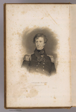
Author
Sully, Thomas
Full Title
Charles Wilkes, Commander U.S.N. Painted by T. Sully. R.W. Dodson sc. (Philadelphia: Lea & Blanchard. 1845)
Publisher
Lea & Blanchard
Author
[United States Exploring Expedition (1838-1842), Wilkes, Charles, 1798-1877]
Full Title
(Title Page to) Narrative of the United States Exploring Expedition During the Years 1838, 1839, 1840, 1841, 1842. By Charles Wilkes, U.S.N. Commander of the Expedition, member of the American Philosophical Society, etc. In Five Volumes, and an atlas. Vol. I. Philadelphia: Lea & Blanchard. 1845. (on verso) Entered ... 1844, By Charles Wilkes ... District of Columbia.
Publisher
Lea & Blanchard
Author
[United States Exploring Expedition (1838-1842), Wilkes, Charles, 1798-1877]
Full Title
(Half Title Page to) Narrative of the United States Exploring Expedition During the Years 1838, 1839, 1840, 1841, 1842. By Charles Wilkes, U.S.N. Commander of the Expedition, member of the American Philosophical Society, etc. In Five Volumes, and an atlas. Vol. II. Philadelphia: Lea & Blanchard. 1845. (on verso) Entered ... 1844, By Charles Wilkes ... District of Columbia.
Publisher
Lea & Blanchard
Author
Agate, A. T.
Full Title
Wm. L. Hudson, Commander U.S.N. (Drawn by) A.T. Agate. (Engraved by) Jordan & Halpin. (Philadelphia: Lea & Blanchard. 1845)
Publisher
Lea & Blanchard
Author
[United States Exploring Expedition (1838-1842), Wilkes, Charles, 1798-1877]
Full Title
(Title Page to) Narrative of the United States Exploring Expedition During the Years 1838, 1839, 1840, 1841, 1842. By Charles Wilkes, U.S.N. Commander of the Expedition, member of the American Philosophical Society, etc. In Five Volumes, and an atlas. Vol. II. Philadelphia: Lea & Blanchard. 1845. (on verso) Entered ... 1844, By Charles Wilkes ... District of Columbia.
Publisher
Lea & Blanchard
Author
[United States Exploring Expedition (1838-1842), Wilkes, Charles, 1798-1877]
Full Title
(Half Title Page to) Narrative of the United States Exploring Expedition During the Years 1838, 1839, 1840, 1841, 1842. By Charles Wilkes, U.S.N. Commander of the Expedition, member of the American Philosophical Society, etc. In Five Volumes, and an atlas. Vol. III. Philadelphia: Lea & Blanchard. 1845. (on verso) Entered ... 1844, By Charles Wilkes ... District of Columbia.
Publisher
Lea & Blanchard
Author
[United States Exploring Expedition (1838-1842), Wilkes, Charles, 1798-1877]
Full Title
(Title Page to) Narrative of the United States Exploring Expedition During the Years 1838, 1839, 1840, 1841, 1842. By Charles Wilkes, U.S.N. Commander of the Expedition, member of the American Philosophical Society, etc. In Five Volumes, and an atlas. Vol. III. Philadelphia: Lea & Blanchard. 1845. (on verso) Entered ... 1844, By Charles Wilkes ... District of Columbia.
Publisher
Lea & Blanchard
Author
[United States Exploring Expedition (1838-1842), Wilkes, Charles, 1798-1877]
Full Title
(Half Title Page to) Narrative of the United States Exploring Expedition During the Years 1838, 1839, 1840, 1841, 1842. By Charles Wilkes, U.S.N. Commander of the Expedition, member of the American Philosophical Society, etc. In Five Volumes, and an atlas. Vol. IV. Philadelphia: Lea & Blanchard. 1845. (on verso) Entered ... 1844, By Charles Wilkes ... District of Columbia.
Publisher
Lea & Blanchard
Author
[United States Exploring Expedition (1838-1842), Wilkes, Charles, 1798-1877]
Full Title
(Title Page to) Narrative of the United States Exploring Expedition During the Years 1838, 1839, 1840, 1841, 1842. By Charles Wilkes, U.S.N. Commander of the Expedition, member of the American Philosophical Society, etc. In Five Volumes, and an atlas. Vol. IV. Philadelphia: Lea & Blanchard. 1845. (on verso) Entered ... 1844, By Charles Wilkes ... District of Columbia.
Publisher
Lea & Blanchard
Author
[United States Exploring Expedition (1838-1842), Wilkes, Charles, 1798-1877]
Full Title
(Half Title Page to) Narrative of the United States Exploring Expedition During the Years 1838, 1839, 1840, 1841, 1842. By Charles Wilkes, U.S.N. Commander of the Expedition, member of the American Philosophical Society, etc. In Five Volumes, and an atlas. Vol. V. Philadelphia: Lea & Blanchard. 1845. (on verso) Entered ... 1844, By Charles Wilkes ... District of Columbia.
Publisher
Lea & Blanchard
Author
[United States Exploring Expedition (1838-1842), Wilkes, Charles, 1798-1877]
Full Title
(Title Page to) Narrative of the United States Exploring Expedition During the Years 1838, 1839, 1840, 1841, 1842. By Charles Wilkes, U.S.N. Commander of the Expedition, member of the American Philosophical Society, etc. In Five Volumes, and an atlas. Vol. V. Philadelphia: Lea & Blanchard. 1845. (on verso) Entered ... 1844, By Charles Wilkes ... District of Columbia.
Publisher
Lea & Blanchard
Author
Burr, David H., 1803-1875
Full Title
(Covers to) A New Universal Atlas; Comprising Separate Maps Of all the Principal Empires, Kingdoms & States Throughout the World: and forming a distinct Atlas Of The United States. Carefully Compiled from the best Authorities Extant by David H. Burr. Published by D.S. Stone, N. York. Printed by Cammeyer & Clark, N.Y.
Publisher
D.S. Stone
Author
Burr, David H., 1803-1875
Full Title
(Title Page to) A New Universal Atlas; Comprising Separate Maps Of all the Principal Empires, Kingdoms & States Throughout the World: and forming a distinct Atlas Of The United States. Carefully Compiled from the best Authorities Extant by David H. Burr. Published by D.S. Stone, N. York. Printed by Cammeyer & Clark, N.Y.
Publisher
D.S. Stone
Full Title
Map illustrative of the currents and whaling grounds by the U.S. Ex. Ex. (Philadelphia: Lea & Blanchard. 1845)
Publisher
Lea & Blanchard
Author
Burr, David H., 1803-1875
Full Title
(Contents to) A New Universal Atlas; Comprising Separate Maps Of all the Principal Empires, Kingdoms & States Throughout the World: and forming a distinct Atlas Of The United States. Carefully Compiled from the best Authorities Extant by David H. Burr. Published by D.S. Stone, N. York. Printed by Cammeyer & Clark, N.Y.
Publisher
D.S. Stone
Author
Cram, George Franklin
Full Title
Map of the World on Mercator's projection. Published by Geo. F. Cram, Chicago, Ill. (1909)
Publisher
E.A. Davis
Author
Cary, John, ca. 1754-1835
Full Title
(Covers to) Chart of the world upon Mercator's projection drawn from the most recent geographical materials exhibiting the whole of the new discoveries with the tracks of the principal navigators accurately adjusted from the most exact astronomical observations. London; published By John Cary, No. 181 Strand June 1819.
Publisher
John Cary
Author
Davis, Ellis Arthur
Full Title
(Covers to) Davis' new commercial encyclopedia, the Pacific Northwest: Washington, Oregon and Idaho. Published by Ellis A. Davis. Berkeley, Cal. Seattle. 1909.
Publisher
E.A. Davis
Author
Davis, Ellis Arthur
Full Title
(Title Page to) Davis' new commercial encyclopedia, the Pacific Northwest: Washington, Oregon and Idaho. Published by Ellis A. Davis. Berkeley, Cal. Seattle. 1909.
Publisher
E.A. Davis
Author
Davis, Ellis Arthur
Full Title
(Contents to) Davis' new commercial encyclopedia, the Pacific Northwest: Washington, Oregon and Idaho. Published by Ellis A. Davis. Berkeley, Cal. Seattle. 1909.
Publisher
E.A. Davis
Author
Cary, John, ca. 1754-1835
Full Title
Chart of the world upon Mercator's projection drawn from the most recent geographical materials exhibiting the whole of the new discoveries with the tracks of the principal navigators accurately adjusted from the most exact astronomical observations. London; published By John Cary, No. 181 Strand June 1819.
Publisher
John Cary
Author
Flemming, Carl
Full Title
Geogr. Verbreitung des Christlichen Staaten Systems auf der ganzen Erde. Lith., Druck u. Verlag v. C. Flemming in Glogau. (1855)
Publisher
C. Flemming
Author
[Berghaus, Heinrich, Flemming, Carl, Sohr, Karl]
Full Title
(Covers to) Vollstandiger Hand-Atlas der neueren Erdbeschreibung uber alle Theile der Erde in 82 Blattern herausgegben von Dr. K. Sohr. Vt. Auflage vermehrt und verbessert durch Dr. Heinrich Berghaus, Professor u. Director der geograph. Kunstschule zu Potsdam. Glogau und Leipzig 1855. Druck u. Verlag von C. Flemming.
Publisher
C. Flemming
Author
[Berghaus, Heinrich, Flemming, Carl, Sohr, Karl]
Full Title
(Title Page to) Vollstandiger Hand-Atlas der neueren Erdbeschreibung uber alle Theile der Erde in 82 Blattern herausgegben von Dr. K. Sohr. Vt. Auflage vermehrt und verbessert durch Dr. Heinrich Berghaus, Professor u. Director der geograph. Kunstschule zu Potsdam. Glogau und Leipzig 1855. Druck u. Verlag von C. Flemming. (with) Supplementband, 32 Blattern.
Publisher
C. Flemming
Author
[Berghaus, Heinrich, Flemming, Carl, Sohr, Karl]
Full Title
(Contents to) Vollstandiger Hand-Atlas der neueren Erdbeschreibung uber alle Theile der Erde in 82 Blattern herausgegben von Dr. K. Sohr. Vt. Auflage vermehrt und verbessert durch Dr. Heinrich Berghaus, Professor u. Director der geograph. Kunstschule zu Potsdam. Glogau und Leipzig 1855. Druck u. Verlag von C. Flemming. (with) Supplementband, 32 Blattern.
Publisher
C. Flemming
Author
[Asher & Adams, Higgins & Ryan]
Full Title
Higgins & Ryan's World on Mercators projection. Entered according to act of Congress in the year 1871 by Asher & Adams, in the office of the Librarian of Congress at Washington. (Indianapolis: Higgins & Ryan, 1871?)
Publisher
Higgins & Ryan
Full Title
Table of the comparative heights of the principal mountains &c. in the World. (Written and engraved by Jos. Perkins. 1845)
Publisher
Tanner's Geographical Establishment
Full Title
Index map to charts. George Philip & Son, Ltd. The London Geographical Institute. (1922)
Publisher
[C.S. Hammond & Company. London: George Philip & Son, Ltd. The London Geographical Institute, Philip, Son & Nephew, Ltd.]
Full Title
Commercial chart of the World. George Philip & Son, Ltd. The London Geographical Institute. (1922)
Publisher
[C.S. Hammond & Company. London: George Philip & Son, Ltd. The London Geographical Institute, Philip, Son & Nephew, Ltd.]
Author
[Brue, Adrien Hubert, 1786-1832, Picquet, C.]
Full Title
Mappemonde aux la projection de Mercator, par A. Brue, Geographe du Roi. Revue et augmentee par Chles. Picquet, Geographe du Roi et du Duc d'Orleans. Paris, Chez Chles. Picquet, Quai Conti No. 17, pres du Pont des Arts. 1842.
Publisher
C. Picquet
Author
[Brue, Adrien Hubert, 1786-1832, Picquet, C.]
Full Title
Mappemonde en deux hemispheres. Dressee par A. Brue, Geographe du Roi. Revue et augmentee par Ch. Picquet, Geographe du Roi et du Duc d'Orleans. A Paris, Chez Ch. Picquet, Quai Conti No. 17, pres du Pont des Arts, 1842.
Publisher
C. Picquet
Author
[Brue, Adrien Hubert, 1786-1832, Picquet, C.]
Full Title
Mappemonde projetee sur l'horizon de Paris et sur son antipode. Mappemonde sur la projection polaire. Cartes dressees par A. Brue, Geographe du Roi. Revue et augmentee par Charles Picquet, Geographe du Roi et du Duc d'Orleans, Quai Conti No. 17, pres du Pont des Arts. Paris 1842.
Publisher
C. Picquet
|