Who What Where When |
REFINE
Browse All : Images by Anville, Jean Baptiste Bourguignon d, 1697-1782 and Laurie & Whittle
1-24 of 24
Author
[Anville, Jean Baptiste Bourguignon d, 1697-1782, Dunn, Samuel, Robert Laurie & James Whittle]
Full Title
A general map of the World or terraqueous globe with all the new discoveries and marginal delineations, containing the most interesting particulars of the solar, starry and mundane system, by Saml. Dunn, mathematician. (North half). London, Published by Laurie & Whittle, No. 53, Fleet Street, 12th May, 1799.
Publisher
Laurie & Whittle
Author
[Anville, Jean Baptiste Bourguignon d, 1697-1782, Dunn, Samuel, Riccioli, Giovanni Battista, Robert Laurie & James Whittle]
Full Title
(A general map of the World or terraqueous globe with all the new discoveries and marginal delineations, containing the most interesting particulars of the solar, starry and mundane system, by Saml. Dunn, mathematician. South half. London, Published by Laurie & Whittle, No. 53, Fleet Street, 12th May, 1799)
Publisher
Laurie & Whittle
Author
[Anville, Jean Baptiste Bourguignon d, 1697-1782, Dunn, Samuel, Riccioli, Giovanni Battista, Robert Laurie & James Whittle]
Full Title
(Composite of) A general map of the World or terraqueous globe with all the new discoveries and marginal delineations, containing the most interesting particulars of the solar, starry and mundane system, by Saml. Dunn, mathematician. London, Published by Laurie & Whittle, No. 53, Fleet Street, 12th May, 1799.
Publisher
Laurie & Whittle
Author
[Anville, Jean Baptiste Bourguignon d, 1697-1782, Kitchin, Thomas, Robert Laurie & James Whittle]
Full Title
Europe divided into its empires, kingdoms, states, republics, &c. (North half). By Thos. Kitchin, Hydrographer to the King, with many additions and improvements from the latest surveys and observations of Mr. d'Anville. London, Published by Laurie & Whittle, No. 53, Fleet Street, 12th May, 1795.
Publisher
Laurie & Whittle
Full Title
(Europe divided into its empires, kingdoms, states, republics, &c. (South half). By Thos. Kitchin, Hydrographer to the King, with many additions and improvements from the latest surveys and observations of Mr. d'Anville. London, Published by Laurie & Whittle, No. 53, Fleet Street, 12th May, 1795)
Publisher
Laurie & Whittle
Author
[Anville, Jean Baptiste Bourguignon d, 1697-1782, Kitchin, Thomas, Robert Laurie & James Whittle]
Full Title
(Composite of) Europe divided into its empires, kingdoms, states, republics, &c. By Thos. Kitchin, Hydrographer to the King, with many additions and improvements from the latest surveys and observations of Mr. d'Anville. London, Published by Laurie & Whittle, No. 53, Fleet Street, 12th May, 1795.
Publisher
Laurie & Whittle
Author
[Anville, Jean Baptiste Bourguignon d, 1697-1782, Robert Laurie & James Whittle]
Full Title
A new map of Italy, with the islands of Sicily, Sardinia & Corsica. From Monsr. D'Anville: to which have been added the post roads and several other improvements. London, Published by Laurie & Whittle, No. 53 Fleet Street, as the act directs 12th May, 1794. (Title in upper margin:) Carte de l'Italie, et de toutes ses routes de poste, a l'usage des voyageurs.
Publisher
Laurie & Whittle
Author
[Anville, Jean Baptiste Bourguignon d, 1697-1782, Robert Laurie & James Whittle]
Full Title
A new map of the middle and upper parts of Italy, wherein are included the State of the Church, the Grand Duchy of Tuscany; Austrian Lombardy; the states of Parma and Modena, and the republics of Venice, Genoa, Lucca &ca. with the island of Corsica. Drawn with many improvements and additions, from the general map of D'Anville &c. &c. Published 25th March 1799 by Robt. Laurie & Jas. Whittle, No. 53 Fleet Street, London. Jones & Smith sculp., 13 Pleasant Row, Pentonville.
Publisher
Laurie & Whittle
Author
[Anville, Jean Baptiste Bourguignon d, 1697-1782, Robert Laurie & James Whittle]
Full Title
Asia and its islands according to d'Anville; divided into empires, kingdoms, states, regions, &c. &c. with the European possessions and settlements in the East Indies and an exact delineation of all the discoveries made in the eastern parts by the English under Captn. Cook, Vancouver & Peyrouse. (North sheets). London, Publish'd by Laurie & Whittle, No. 53, Fleet Street, Feby. 2d, 1799.
Publisher
Laurie & Whittle
Full Title
(Asia and its islands according to d'Anville; divided into empires, kingdoms, states, regions, &c. &c. with the European possessions and settlements in the East Indies and an exact delineation of all the discoveries made in the eastern parts by the English under Captn. Cook, Vancouver & Peyrouse. Middle sheets. London, Publish'd by Laurie & Whittle, No. 53, Fleet Street, Feby. 2d, 1799)
Publisher
Laurie & Whittle
Full Title
(Asia and its islands according to d'Anville; divided into empires, kingdoms, states, regions, &c. &c. with the European possessions and settlements in the East Indies and an exact delineation of all the discoveries made in the eastern parts by the English under Captn. Cook, Vancouver & Peyrouse. South sheets. London, Publish'd by Laurie & Whittle, No. 53, Fleet Street, Feby. 2d, 1799)
Publisher
Laurie & Whittle
Author
[Anville, Jean Baptiste Bourguignon d, 1697-1782, Robert Laurie & James Whittle]
Full Title
(Composite of) Asia and its islands according to d'Anville; divided into empires, kingdoms, states, regions, &c. &c. with the European possessions and settlements in the East Indies and an exact delineation of all the discoveries made in the eastern parts by the English under Captn. Cook, Vancouver & Peyrouse. London, Publish'd by Laurie & Whittle, No. 53, Fleet Street, Feby. 2d, 1799.
Publisher
Laurie & Whittle
Author
[Anville, Jean Baptiste Bourguignon d, 1697-1782, Robert Laurie & James Whittle]
Full Title
A new map of Turkey in Asia by Monsr. d'Anville, First Geographer to the most Christian King with several additions. London, Published by Laurie & Whittle, No. 53, Fleet Street, as the act directs 12th May, 1794.
Publisher
Laurie & Whittle
Author
[Anville, Jean Baptiste Bourguignon d, 1697-1782, Niebuhr, Carsten, Robert Laurie & James Whittle]
Full Title
A new map of Arabia divided into its several regions and districts. From Monsr. d'Anville, Geographer to the most Christian King with additions and improvements from Mr. Niebuhr. London, Published by Laurie & Whittle, 53 Fleet Street, as the act directs 12th May, 1794.
Publisher
Laurie & Whittle
Author
[Anville, Jean Baptiste Bourguignon d, 1697-1782, Robert Laurie & James Whittle]
Full Title
A new map of the Empire of Persia from Monsr. D'Anville, First Geographer to the most Christian King, with several additions and emendations. London, Published by Laurie & Whittle, 53, Fleet Street, as the act directs 12th May, 1794.
Publisher
Laurie & Whittle
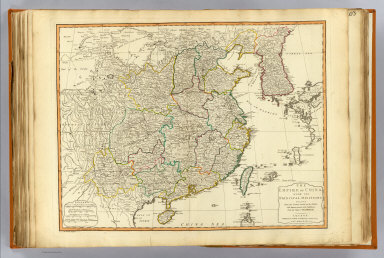
Author
[Anville, Jean Baptiste Bourguignon d, 1697-1782, Robert Laurie & James Whittle]
Full Title
The Empire of China, with its principal divisions; drawn from the surveys made by the Jesuits; with improvements and additions, from the maps of Monsr. D'Anville. London, Published by Laurie & Whittle, 53 Fleet Street, as the act directs 12th May, 1794. M. Bowen, sculpt.
Publisher
Laurie & Whittle
Author
[Anville, Jean Baptiste Bourguignon d, 1697-1782, Jefferys, Thomas, Sayer, Robert]
Full Title
The western coast of Africa from Cape Blanco to Cape Virga, exhibiting Senegambia Proper. By T. Jefferys, Geographer to his Majesty. London, Printed by Robt. Sayer, No. 53, Fleet Street, 1789.
Publisher
Laurie & Whittle
Author
Robert Laurie & James Whittle
Full Title
(A new map of the whole continent of America, divided into north and south and West Indies. North half. Wherein are exactly described the United States of North America as well as the several European possessions according to the Preliminaries of Peace signed at Versailles Jan. 20, 1783. Compiled from Mr. d'Anville's maps of that continent, with the addition of the Spanish discoveries in 1775 to the north of California & corrected in the several parts belonging to Great Britain, from the original materials of Governor Pownall, MP. London, Publish'd by Laurie & Whittle, No. 53, Fleet Street, as the act directs 12th May, 1794)
Publisher
Laurie & Whittle
Author
[Anville, Jean Baptiste Bourguignon d, 1697-1782, Pownall, Thomas, Robert Laurie & James Whittle]
Full Title
A new map of the whole continent of America, divided into north and south and West Indies. (South half). (with) The supplement to North America containing the countries adjoining to Baffins & Hudsons bays. Wherein are exactly described the United States of North America as well as the several European possessions according to the Preliminaries of Peace signed at Versailles Jan. 20, 1783. Compiled from Mr. d'Anville's maps of that continent, with the addition of the Spanish discoveries in 1775 to the north of California & corrected in the several parts belonging to Great Britain, from the original materials of Governor Pownall, MP. London, Publish'd by Laurie & Whittle, No. 53, Fleet Street, as the act directs 12th May, 1794.
Publisher
Laurie & Whittle
Author
[Anville, Jean Baptiste Bourguignon d, 1697-1782, Pownall, Thomas, Robert Laurie & James Whittle]
Full Title
(Composite of) A new map of the whole continent of America, divided into north and south and West Indies. (South half). (with) The supplement to North America containing the countries adjoining to Baffins & Hudsons bays. Wherein are exactly described the United States of North America as well as the several European possessions according to the Preliminaries of Peace signed at Versailles Jan. 20, 1783. Compiled from Mr. d'Anville's maps of that continent, with the addition of the Spanish discoveries in 1775 to the north of California & corrected in the several parts belonging to Great Britain, from the original materials of Governor Pownall, MP. London, Publish'd by Laurie & Whittle, No. 53, Fleet Street, as the act directs 12th May, 1794.
Publisher
Laurie & Whittle
Author
[Anville, Jean Baptiste Bourguignon d, 1697-1782, Robert Laurie & James Whittle]
Full Title
A new and complete map of the West Indies. Comprehending all the coasts and islands known by that name. By Monsr. Danville; with several emendations and improvements. London, Published by Laurie & Whittle, 53 Fleet Street, 12th May, 1794.
Publisher
Laurie & Whittle
Full Title
(A map of South America containing Tierra-Firma, Guayana, New Granada, Amazonia, Brasil, Peru, Paraguay, Chaco, Tucuman, Chili and Patagonia, from Mr. d'Anville with several improvements and additions, and the newest discoveries. North half. (with) A chart of Falkland's Islands named by the French Malouine Islands and discovered by Hawkins, in the year 1593. London, Published by Laurie & Whittle, No. 53 Fleet Street, as the act directs 12th May, 1794)
Publisher
Laurie & Whittle
Author
[Anville, Jean Baptiste Bourguignon d, 1697-1782, Robert Laurie & James Whittle]
Full Title
A map of South America containing Tierra-Firma, Guayana, New Granada, Amazonia, Brasil, Peru, Paraguay, Chaco, Tucuman, Chili and Patagonia, from Mr. d'Anville with several improvements and additions, and the newest discoveries. (South half). London, Published by Laurie & Whittle, No. 53 Fleet Street, as the act directs 12th May, 1794.
Publisher
Laurie & Whittle
Author
[Anville, Jean Baptiste Bourguignon d, 1697-1782, Robert Laurie & James Whittle]
Full Title
(Composite of) A map of South America containing Tierra-Firma, Guayana, New Granada, Amazonia, Brasil, Peru, Paraguay, Chaco, Tucuman, Chili and Patagonia, from Mr. d'Anville with several improvements and additions, and the newest discoveries. (with) A chart of Falkland's Islands named by the French Malouine Islands and discovered by Hawkins, in the year 1593. London, Published by Laurie & Whittle, No. 53 Fleet Street, as the act directs 12th May, 1794.
Publisher
Laurie & Whittle
1-24 of 24
|