Browse All

1807 Chart of Shetland Isles and Orkney Islan … Chart Map (Chart of Shetland Isles and Orkney Isla … |
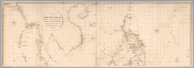
1812 Top sheet: Chart of the East India Islan … Chart Map (Top sheet of) Chart of the East India I … |

1812 Bottom sheet: Chart of the East India Is … Chart Map (Bottom sheet of) Chart of the East Indi … |

1812 Composite: Chart of the East India Islan … Chart Map (Composite of) Chart of the East India I … |

1799 Chart of the coast of Egypt Chart Map Chart of the coast of Egypt, from Alexan … |

1803 Chart Of The West Indies And Spanish Dom … Chart Map Chart Of The West Indies And Spanish Dom … |

1803 Coast of Africa from the Straits of Gibr … Chart Atlas Coast of Africa from the Straits of Gibr … |

1803 Western Coast of Africa, Illustrative Ch … Chart Atlas Western Coast of Africa, Illustrative Ch … |

1803 Coast of Africa, from Cabo Verde to Cabo … Chart Atlas Coast of Africa, from Cabo Verde to Cabo … |

1803 Coast of Africa from Cabo Formosa to the … Chart Atlas Coast of Africa from Cabo Formosa to the … |

1803 Southern Coast of Africa. Chart Atlas Southern Coast of Africa drawn fro a Var … |