Browse All

1869 Title Page: Geological report of the Exp … Exploration Book (Title Page to) Geological Report of the … |

1869 Map Of The Yellowstone And Missouri Rive … Exploration Book U.S. War Department Map Of The Yellowsto … |

1879 Geological map of the district of the hi … [Exploration Book, State Atlas] Geological map of the district of the hi … |

1879 Map of portions of Utah and Arizona show … [Exploration Book, State Atlas] Map of portions of Utah and Arizona show … |

1879 Stereogram of displacements in the distr … [Exploration Book, State Atlas] Stereogram of displacements in the distr … |

1879 Structure sections through the high plat … [Exploration Book, State Atlas] Structure sections through the high plat … |

1879 Structure sections through the high plat … [Exploration Book, State Atlas] Structure sections through the high plat … |

1878 Panoramic Views (Wyoming) View Panoramic Views (Wyoming). W.H. Holmes. … |

1877 Text Page: Geology (continued). (New Ham … State Atlas (Text Page) Geology (continued). (New Ha … |

1877 Text Page: Geology (continued). (New Ham … State Atlas (Text Page) Geology (continued). |

1877 Text Page: Geology (continued). (New Ham … State Atlas (Text Page) Geology (continued). |

1877 Text Page: Geology (concluded). (New Ham … State Atlas (Text Page) Geology (concluded). |

1877 Text Page: Geological Map of New Hampshi … State Atlas (Text Page) Geological Map of New Hampsh … |

1881 Section along 36th parallel Rio Grande-C … Exploration Book Section along 36th parallel from the Rio … |

1881 Section along 37th parallel, Rio Grande- … Exploration Book Section along 37th parallel from the Rio … |

1876 Green River from the Union Pacific Rail … Geologic Atlas Green River from the Union Pacific Rail … |

1876 Structure sections through the Uinta Mou … Geologic Atlas Structure sections through the Uinta Mou … |

1876 Displacement diagrams ... through the Ui … Geologic Atlas Displacement diagrams derived from the S … |

1876 Stereogram of the displacements of the U … Geologic Atlas Stereogram of the displacements of the e … |

1876 Bird's-eye view of a part of the Uinta U … Geologic Atlas Bird's-eye view of a part of the Uinta U … |

1876 Stereogram of the displacements of the U … Geologic Atlas Stereogram of the displacements of the Y … |

1876 Structure sections, displacement diagram … Geologic Atlas No. 1. Structure section through the Asp … |

1879 Bird's eye view of the Black Hills to il … [Exploration Book, Regional Atlas] Bird's eye view of the Black Hills to il … |

1885 Plate XXXVIII: An island of Tufa in Pyra … Geology Book An island of Tufa in Pyramid Lake, Nevad … |

1885 Plate XXXIX: Tufa towers on the shore of … Geology Book Tufa towers on the shore of Pyramid Lake … |

1885 Plate XL: Tufa castle, west of Pyramid L … Geology Book Tufa castle, west of Pyramid Lake, Nevad … |

1885 Plate XLI: Tufa domes in Pyramid Lake, N … Geology Book Tufa domes in Pyramid Lake, Nevada. (to … |

1885 Plate XLII: Tufa tower on the shore of W … Geology Book Tufa tower on the shore of Winnemucca La … |

1885 Plate XLIII: Tufa domes in Mono Lake, Ca … Geology Book Tufa domes in Mono Lake, California. (to … |

1885 Plate XLIV: Post - quaternary fault line … Geology Book Post - quaternary fault lines. Julius Bi … |

1885 Plate XLV: Post - quaternary fault on th … Geology Book Post - quaternary fault on the south sho … |
1885 Plate XLVI: Lake Lahontan : a quaternary … Geology Book Lake Lahontan : a quaternary lake of nor … |

1885 Title Page: Monographs of the United Sta … Geology Book (Title Page to) Department of Interior : … |

1885 Title Page: Monographs of the United Sta … Geology Book (Title Page to) Geological history of La … |

1885 Plate I: Quaternary lakes of the Great B … Geology Book Quaternary lakes of the Great Basin. Jul … |

1885 Plate II: Routes traveled and areas surv … Geology Book Routes traveled and areas surveyed. Juli … |

1885 Plate III: Pre-Quternary fault lines Geology Book Pre-Quternary fault lines. Julius Bien & … |

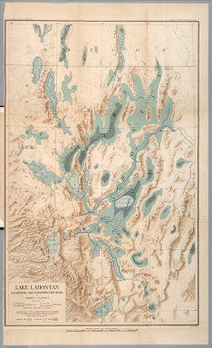
1885 Plate IV: Map of Lake Lahontan Geology Book Map of Lake Lahontan : showing water are … |

1885 Plate V: Depth of Lake Lahontan at highe … Geology Book Depth of Lake Lahontan at highest water … |

1885 Plate VI: Map showing land classificatio … Geology Book Map showing land classification of Lahon … |

1885 Plate VII: Carson Desert, Nevada Geology Book Carson Desert, Nevada. Julius Bien & Co. … |

1885 Plate VIII: Springs of the Lahontan Regi … Geology Book Springs of the Lahontan Region. Julius B … |

1885 Plate IX: Pyramid and Winnemucca Lakes, … Geology Book Pyramid and Winnemucca Lakes, Nevada. W. … |

1885 Plate X: Anaho Island, Pyramid Lake, Nev … Geology Book Anaho Island, Pyramid Lake, Nevada. W.D. … |

1885 Plate XI: Sketch of Pyramid Island, Pyra … Geology Book Sketch of Pyramid Island, Pyramid Lake, … |

1885 Plate XII: The Needles, Pyramid Lake, Ne … Geology Book The Needles, Pyramid Lake, Nevada. (to a … |

1885 Plate XIII: Among he Needles, Pyramid La … Geology Book Among the Needles, Pyramid Lake, Nevada. … |

1885 Plate XIV: Mushroom Rock, north shore of … Geology Book Mushroom Rock, north shore of Anaho Isla … |

1885 Plate XV: Walker Lake, Nevada Geology Book Walker Lake, Nevada. W.D. Johnson, Topog … |

1885 Plate XVI: Soda Lakes near Ragtown, Neva … Geology Book Soda Lakes near Ragtown, Nevada. W.D. Jo … |