Who What Where WhenREMOVE |
REFINE
Browse All : Book Map by Bien, Julius
1-31 of 31
Author
Hayden, F.V.
Full Title
U.S. War Department Map Of The Yellowstone And Missouri Rivers And Their Tributaries explored by Capt. W.F. Raynolds Topl. Engrs. and 1st Lieut. H.E. Maynadier 10th Infy. Assistant. 1859-60. To accompany a report to the Bureau of Topographical Engineers. Lt. Col. Harman Bache in charge. Engraved in the Engineer Bureau War Dept. Prepared to accompany the Geological Report of F.V. Hayden M.D. ... Printed by Julius Bien, N.Y.
Publisher
Government Printing Office
Author
U.S. General Land Office
Full Title
Map of the United States and Territories, Showing the extent of Public Surveys and other details. Constructed From the Plats and official sources of the General Land Office, Under the direction of the Hon. Jos. S. Wilson, Commissioner, by Joseph Gorlinski, Draughtsman, 1867. Julius Bien, N.Y. Department of the Interior General Land Office Oct. 15th 1867. Jos. S. Wilson, Commissioner.
Publisher
Government Printing Office
Author
[Pacific Railroad Survey, Warren, Gouverneur Kemble, 1830-1882, Winterbotham, W.]
Full Title
Reduced section of a general map of North America. Drawn from the best surveys. 1795. To accompany Winterbotham's History. Published by John Reid, New York. Lith of J. Bien, 60 Fulton St., N.Y. U.S. Pacific R.R. Exp. & Surveys. Lt. Warren's Memoir Plate I. (1861)
Publisher
[A.O.P. Nicholson I-XI, T. Ford XII.]
Author
[Pacific Railroad Survey, Warren, Gouverneur Kemble, 1830-1882]
Full Title
Reduced section of a sketch of the western part of the continent of North America between latitudes 35 (degrees) and 52 (degrees) Nth. 1818. Lith of J. Bien, 60 Fulton St., N.Y. U.S. Pacific R.R. Exp. & Surveys. Lt. Warren's Memoir Plate II. (1861)
Publisher
[A.O.P. Nicholson I-XI, T. Ford XII.]
Author
[Pacific Railroad Survey, Warren, Gouverneur Kemble, 1830-1882]
Full Title
Reduced section of map of North America including all the recent geographical discoveries. 1826. Lith of J. Bien, 60 Fulton St., N.Y. U.S. Pacific R.R. Exp. & Surveys. Lt. Warren's Memoir Plate III. (1861)
Publisher
[A.O.P. Nicholson I-XI, T. Ford XII.]
Author
[Bonneville, Benjamin Louis Eulalie de, Pacific Railroad Survey, Warren, Gouverneur Kemble, 1830-1882]
Full Title
Reduced map of the territory west of the Rocky Mountains. By Capt. B.L.E. Bonneville, U.S.A. 1837. Lith of J. Bien, 60 Fulton St., N.Y. U.S. Pacific R.R. Exp. & Surveys. Lt. Warren's Memoir Plate IV. (1861)
Publisher
[A.O.P. Nicholson I-XI, T. Ford XII.]
Author
Powell, John Wesley, 1834-1902.
Full Title
Sketch of Black Rock and vicinity, Utah Territory, Prepared to show the position of the graduated pillar erected by Dr. John Park for observation on the water-level of Great Salt Lake, and the position of the granite bench-mark. (to accompany) Report on the Lands of the Arid Region of the United States, with a More Detailed Account of the Lands of Utah. With Maps. By J.W. Powell. Second edition. Washington: Government Printing Office. 1879.
Publisher
Government Printing Office
Author
Powell, John Wesley, 1834-1902.
Full Title
Comparative map of Great Salt Lake, Utah : compiled to show its increase of area ... (to accompany) Report on the Lands of the Arid Region of the United States, with a More Detailed Account of the Lands of Utah. With Maps. By J.W. Powell. Second edition. Washington: Government Printing Office. 1879.
Publisher
Government Printing Office
Author
Powell, John Wesley, 1834-1902.
Full Title
Map of Utah territory : representing the extent of the irrigable, timber and pasture lands ; compiled and drawn by Charles Mahon, J.H. Renshawe, W.H. Graves and H. Lindenkohl for the Commissioner of Public Lands. (at head of title) Department of the Interior, U.S. Geographical and Geological Survey of the Rocky Mountain region, J.W. Powell in charge. (on upper margin) To accompany report on the Lands of the Arid Region of the U.S.
Publisher
Government Printing Office
Author
Powell, John Wesley, 1834-1902.
Full Title
Map of the United States exhibiting the grants of lands made by the general government to aid in the construction of railroads and wagon roads. For explanation see chapter on "L̀and grants in aid of internal improvements". Julius Bien, Lithographer. (at head of title) Department of the Interior, U.S. Geographical and Geological Survey of the Rocky Mountain region, J.W. Powell in charge. (on upper margin) To accompany report on the Lands of the Arid Region of the U.S.
Publisher
Government Printing Office
Author
Powell, John Wesley, 1834-1902.
Full Title
Rain chart of the United States : showing by isohyetal lines the distribution of the mean annual precipitation in rain and melted snow. This is a copy of the chart constructed for the Smithsonian Institution in 1868 by Charles A Schott ... Julius Bien, Lithographer. (at head of title) Department of the Interior, U.S. Geographical and Geological Survey of the Rocky Mountain region, J.W. Powell in charge. (on upper margin) To accompany report on the Lands of the Arid Region of the U.S.
Publisher
Government Printing Office
Author
Russell, Israel C. (Israel Cook), 1852-1906.
Full Title
Post - quaternary fault lines. Julius Bien & Co. Lith. (to accompany) Geological history of Lake Lahontan : a quaternary lake of Northwestern Nevada. (series title) Department of Interior : Monographs of the United States Geological Survey, vol. XI. (on upper margin) U.S. Geological Survey; Lake Lahontan PL. XLIV.
Publisher
U.S. Govt. Print Office
Author
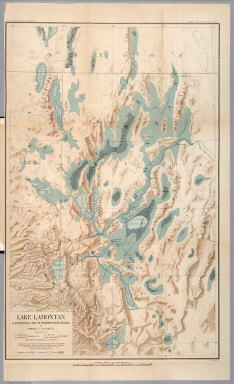
Russell, Israel C. (Israel Cook), 1852-1906.
Full Title
Lake Lahontan : a quaternary lake of northwestern Nevad, by Israel C. Russell. Assisted by A.L. Webster, W.D. Johnson, cartographers ; W.J. McGee. GEO. M. Wright, geologists. Mountain shading, by W.J. Hays. Topography compiled by Eugene Rickseker ... (to accompany) Geological history of Lake Lahontan : a quaternary lake of Northwestern Nevada. (series title) Department of Interior : Monographs of the United States Geological Survey, vol. XI. (on upper margin) U.S. Geological Survey; Lake Lahontan PL. XLVI.
Publisher
U.S. Govt. Print Office
Author
Russell, Israel C. (Israel Cook), 1852-1906.
Full Title
Quaternary lakes of the Great Basin. Julius Bien & Co. Lith. (to accompany) Geological history of Lake Lahontan : a quaternary lake of Northwestern Nevada. (series title) Department of Interior : Monographs of the United States Geological Survey, vol. XI. (on upper margin) U.S. Geological Survey; Lake Lahontan PL. I.
Publisher
U.S. Govt. Print Office
Author
Russell, Israel C. (Israel Cook), 1852-1906.
Full Title
Routes traveled and areas surveyed. Julius Bien & Co. Lith. (to accompany) Geological history of Lake Lahontan : a quaternary lake of Northwestern Nevada. (series title) Department of Interior : Monographs of the United States Geological Survey, vol. XI. (on upper margin) U.S. Geological Survey; Lake Lahontan PL. II.
Publisher
U.S. Govt. Print Office
Author
Russell, Israel C. (Israel Cook), 1852-1906.
Full Title
Pre-Quternary fault lines. Julius Bien & Co. Lith. (to accompany) Geological history of Lake Lahontan : a quaternary lake of Northwestern Nevada. (series title) Department of Interior : Monographs of the United States Geological Survey, vol. XI. (on upper margin) U.S. Geological Survey; Lake Lahontan PL. III.
Publisher
U.S. Govt. Print Office
Author
Russell, Israel C. (Israel Cook), 1852-1906.
Full Title
Map of Lake Lahontan : showing water area and boundary of hydrographic basin by Israel C. Russell. Julius Bien & Co. Lith. (to accompany) Geological history of Lake Lahontan : a quaternary lake of Northwestern Nevada. (series title) Department of Interior : Monographs of the United States Geological Survey, vol. XI. (on upper margin) U.S. Geological Survey; Lake Lahontan PL. IV.
Publisher
U.S. Govt. Print Office
Author
Russell, Israel C. (Israel Cook), 1852-1906.
Full Title
Depth of Lake Lahontan at highest water stage. Julius Bien & Co. Lith. (to accompany) Geological history of Lake Lahontan : a quaternary lake of Northwestern Nevada. (series title) Department of Interior : Monographs of the United States Geological Survey, vol. XI. (on upper margin) U.S. Geological Survey; Lake Lahontan PL. V.
Publisher
U.S. Govt. Print Office
Author
Russell, Israel C. (Israel Cook), 1852-1906.
Full Title
Map showing land classification of Lahontan Region. Julius Bien & Co. Lith. (to accompany) Geological history of Lake Lahontan : a quaternary lake of Northwestern Nevada. (series title) Department of Interior : Monographs of the United States Geological Survey, vol. XI. (on upper margin) U.S. Geological Survey; Lake Lahontan PL. VI.
Publisher
U.S. Govt. Print Office
Author
Russell, Israel C. (Israel Cook), 1852-1906.
Full Title
Carson Desert, Nevada. Julius Bien & Co. Lith. (to accompany) Geological history of Lake Lahontan : a quaternary lake of Northwestern Nevada. (series title) Department of Interior : Monographs of the United States Geological Survey, vol. XI. (on upper margin) U.S. Geological Survey; Lake Lahontan PL. VII.
Publisher
U.S. Govt. Print Office
Author
Russell, Israel C. (Israel Cook), 1852-1906.
Full Title
Springs of the Lahontan Region. Julius Bien & Co. Lith. (to accompany) Geological history of Lake Lahontan : a quaternary lake of Northwestern Nevada. (series title) Department of Interior : Monographs of the United States Geological Survey, vol. XI. (on upper margin) U.S. Geological Survey; Lake Lahontan PL. VIII.
Publisher
U.S. Govt. Print Office
Author
Russell, Israel C. (Israel Cook), 1852-1906.
Full Title
Pyramid and Winnemucca Lakes, Nevada. W.D. Johnson, Topograper. I.C. Russell, Geologist. (to accompany) Geological history of Lake Lahontan : a quaternary lake of Northwestern Nevada. (series title) Department of Interior : Monographs of the United States Geological Survey, vol. XI. (on upper margin) U.S. Geological Survey; Lake Lahontan PL. IX.
Publisher
U.S. Govt. Print Office
Author
Russell, Israel C. (Israel Cook), 1852-1906.
Full Title
Anaho Island, Pyramid Lake, Nevada. W.D. Johnson, Topograper. I.C. Russell, Geologist. (to accompany) Geological history of Lake Lahontan : a quaternary lake of Northwestern Nevada. (series title) Department of Interior : Monographs of the United States Geological Survey, vol. XI. (on upper margin) U.S. Geological Survey; Lake Lahontan PL. X.
Publisher
U.S. Govt. Print Office
Author
Russell, Israel C. (Israel Cook), 1852-1906.
Full Title
Walker Lake, Nevada. W.D. Johnson, Topographer. I.C. Russell, Geologist. (to accompany) Geological history of Lake Lahontan : a quaternary lake of Northwestern Nevada. (series title) Department of Interior : Monographs of the United States Geological Survey, vol. XI. (on upper margin) U.S. Geological Survey; Lake Lahontan PL. XV.
Publisher
U.S. Govt. Print Office
Author
Russell, Israel C. (Israel Cook), 1852-1906.
Full Title
Soda Lakes near Ragtown, Nevada. W.D. Johnson, Topographer. I.C. Russell, Geologist. (to accompany) Geological history of Lake Lahontan : a quaternary lake of Northwestern Nevada. (series title) Department of Interior : Monographs of the United States Geological Survey, vol. XI. (with inset).
Publisher
U.S. Govt. Print Office
Author
Russell, Israel C. (Israel Cook), 1852-1906.
Full Title
Gravel embarkments at west end of Humboldt Lake, Nevada. W.D. Johnson. Topographer. I.C. Russell, Geologist. (to accompany) Geological history of Lake Lahontan : a quaternary lake of Northwestern Nevada. (series title) Department of Interior : Monographs of the United States Geological Survey, vol. XI. (on upper margin) U.S. Geological Survey; Lake Lahontan PL. XVIII.
Publisher
U.S. Govt. Print Office
Author
Russell, Israel C. (Israel Cook), 1852-1906.
Full Title
Gravel embarkments on south border of the Carson Desert, Nevada. W.D. Johnson. Topographer. I.C. Russell, Geologist. (to accompany) Geological history of Lake Lahontan : a quaternary lake of Northwestern Nevada. (series title) Department of Interior : Monographs of the United States Geological Survey, vol. XI. (on upper margin) U.S. Geological Survey; Lake Lahontan PL. XIX.
Publisher
U.S. Govt. Print Office
Author
Russell, Israel C. (Israel Cook), 1852-1906.
Full Title
Gravel embarkments at Buffalo Springs, Nevada. W.D. Johnson. Topographer. I.C. Russell, Geologist. (to accompany) Geological history of Lake Lahontan : a quaternary lake of Northwestern Nevada. (series title) Department of Interior : Monographs of the United States Geological Survey, vol. XI. (on upper margin) U.S. Geological Survey; Lake Lahontan PL. XX.
Publisher
U.S. Govt. Print Office
Author
Russell, Israel C. (Israel Cook), 1852-1906.
Full Title
Gravel embarkments three miles south of Buffalo Springs, Nevada. W.D. Johnson. Topographer. I.C. Russell, Geologist. (to accompany) Geological history of Lake Lahontan : a quaternary lake of Northwestern Nevada. (series title) Department of Interior : Monographs of the United States Geological Survey, vol. XI. (on upper margin) U.S. Geological Survey; Lake Lahontan PL. XXI.
Publisher
U.S. Govt. Print Office
Author
Russell, Israel C. (Israel Cook), 1852-1906.
Full Title
Present drainage areas of the Lahontan Region. Julius Bien & Co. Lith. (to accompany) Geological history of Lake Lahontan : a quaternary lake of Northwestern Nevada. (series title) Department of Interior : Monographs of the United States Geological Survey, vol. XI. (on upper margin) U.S. Geological Survey; Lake Lahontan PL.XXIX.
Publisher
U.S. Govt. Print Office
Author
Russell, Israel C. (Israel Cook), 1852-1906.
Full Title
Water surface on Lake Lahontan at thinolite stage. Juliud Bien & Co. Lith. (to accompany) Geological history of Lake Lahontan : a quaternary lake of Northwestern Nevada. (series title) Department of Interior : Monographs of the United States Geological Survey, vol. XI. (on upper margin) U.S. Geological Survey; Lake Lahontan PL. XXXI.
Publisher
U.S. Govt. Print Office
1-31 of 31
|