Who What Where WhenREMOVEWHERE
WHOShow More |
Author
[Britton & Rey, San Francisco City]
Full Title
Map of the proposed line of Montgomery Avenue from the corner Washington and Montgomery Street to the corner of Union and Stockton Street. Length 2354 feet, Width 80 feet. Britton & Rey.
Publisher
Britton & Rey
Author
Britton & Rey
Full Title
Britton & Rey's Guide Map of the City of San Francisco. 1887. Copyright. (with) Geo. F. Schild's Map Attachment. Patented Dec. 8th 1885.
Publisher
Britton & Rey
Author
Britton & Rey
Full Title
(Covers to) Britton & Rey's Guide Map of the City of San Francisco. 1887. Copyright. (with) Geo. F. Schild's Map Attachment. Patented Dec. 8th 1885. (and with) Index of Britton & Rey's Street Guide Map of the City and County of San Francisco, with Geo. F. Schild's Patented Attachment for Finding Instantly Any Point or Distance on Map. (on verso) Map: Copyrighted by Britton & Rey, August, 1886. Attachment: Patented by Geo. F. Schild, December 8th, 1885.
Publisher
Britton & Rey
Author
Britton & Rey
Full Title
Map showing the Golden Gate Park, The Avenue And Buena Vista Park. 1903. Lith. Britton & Rey, S.F.
Publisher
Britton & Rey
Author
Britton & Rey
Full Title
Map of San Francisco, Compiled from latest Surveys & containing all late extensions & Division of Wards. Published By Britton & Rey, San Francisco Cal.
Publisher
Britton & Rey
Author
[Arnold, T. J. (Thomas Jefferson), d. 1878, California. Board of State Harbor Commissioners for San Francisco Harbor]
Full Title
Map exhibiting the salt marsh, tide and submerged lands disposed of by the State of California in and adjacent to the bays of San Francisco and San Pablo and now subject to reclamation. Prepared from maps of the U.S. Coast Survey & official records by order of the Board of State Harbor Commissioners for the United States Commissioners on San Francisco Harbor. By T.J. Arnold, engineer of the sea wall. 1874. U.S. Commissioners Rear Admiral John Rodgers, Major G.H. Mendell, Prof. George Davidson. State Harbor Commissioners Samuel Soule, T.D. Mathewson, D.C. McRuer. Britton Rey & Co. Lith. S.F.
Publisher
Britton & Rey
Author
[McMurray, William, Layne, J.P.]
Full Title
(Covers to) Map Of White Pine District Lander Co. Nev. Showing The Principal Mines. Made For J.P. Layne Esq. By Wm. Mc.Murray, C.E. Septr. 1868. Lith. Britton & Rey, S.F. (with profile) Section Through A.B. Treasure Mountain.
Publisher
Britton & Rey
Author
[McMurray, William, Layne, J.P.]
Full Title
Map Of White Pine District Lander Co. Nev. Showing The Principal Mines. Made For J.P. Layne Esq. By Wm. Mc.Murray, C.E. Septr. 1868. Lith. Britton & Rey, S.F. (with profile) Section Through A.B. Treasure Mountain.
Publisher
Britton & Rey
Author
[C.H. Street & Co., Immigration Association of California]
Full Title
Map of the state of California, compiled expressly for C.H. Street & Co., successors to the Immigration Association of California, 415 Montgomery St., San Francisco ... Lith. Britton & Rey, S.F. (1886?)
Publisher
Britton & Rey
Author
[C.H. Street & Co., Immigration Association of California]
Full Title
(Covers to) Map of the state of California, compiled expressly for C.H. Street & Co., successors to the Immigration Association of California, 415 Montgomery St., San Francisco ... Lith. Britton & Rey, S.F. (1886?)
Publisher
Britton & Rey
Author
[C.H. Street & Co., Immigration Association of California]
Full Title
(Text Page to) Map of the state of California, compiled expressly for C.H. Street & Co., successors to the Immigration Association of California, 415 Montgomery St., San Francisco ... Lith. Britton & Rey, S.F. (1886?)
Publisher
Britton & Rey
Author
Higley, Horace A.
Full Title
Official Map Of The County Of Alameda California Surveyed and compiled by Order of the Board of Supervisors. Horace A. Higley, County Surveyor. April - 1857. Lithy. of Britton & Rey, S.F.
Publisher
Britton & Rey
Author
Goddard, George H. (George Henry), 1817-1906
Full Title
Britton & Rey's Map Of The State Of California. Compiled from the U.S. Land & Coast Surveys, the several Military, Scientific & Rail Road Explorations, the State & County Boundary Surveys made under the Order of the Surveyor General of California, & from Private Surveys. By George H. Goddard, C.E. Completed with Additions & Corrections up to the day of publication from the U.S. Land Office & other reliable sources. Lithy. Of Britton & Rey, Montgomery St. Cor. Commercial, S.F. Entered ... 1857 by Britton & Rey ... California. Engraved by H. Steinegger.
Publisher
Britton & Rey
Author
Weber, C.F.
Full Title
(Covers to) Weber's Township And County Map Of California And Nevada Compiled From The Latest Official Data. Published By C.F. Weber & Co. San Francisco And Los Angeles California. Copyright, 1910, By C.F. Weber & Co. Photo-Lith. Britton & Rey.
Publisher
C.F. Weber & Co.
Author
Weber, C.F.
Full Title
(Title Page to) Weber's Township And County Map Of California And Nevada Compiled From The Latest Official Data. Published By C.F. Weber & Co. San Francisco And Los Angeles California. Copyright, 1910, By C.F. Weber & Co. Photo-Lith. Britton & Rey.
Publisher
C.F. Weber & Co.
Author
Weber, C.F.
Full Title
Weber's Township And County Map Of California And Nevada Compiled From The Latest Official Data. Published By C.F. Weber & Co. San Francisco And Los Angeles California. Copyright, 1910, By C.F. Weber & Co. Photo-Lith. Britton & Rey.
Publisher
C.F. Weber & Co.
Author
San Francisco Board of Supervisors
Full Title
Map Of The Outside Lands Of The City And County Of San Francisco Showing Reservations Selected for Public Purposes, under the Provisions of Order No. 800 ... Litho. Britton & Rey.
Publisher
Britton & Rey
Author
San Francisco Board of Supervisors
Full Title
Map Of The Outside Lands Of The City And County Of San Francisco Showing Reservations Selected for Public Purposes, under the Provisions of Order No. 800 ... Litho. Britton & Rey.
Publisher
Britton & Rey
Author
Rumble, A. C.
Full Title
(Covers to) Second grand excursion to, and monster auction sale of lots and blocks in Park Place, a subdivision of the famous Laundry Farm, By Bovee, Toy & Co., on Saturday, September 8th, 1888. (to accompany) Map showing A Portion Of Park Place, Formerly Known As "Laundry Farm" Adjoining Mills Seminary On The Line Of The Alameda County Railway : Alameda County, Cal. Scale 200'=1". Surveyed July, 1888 A.C. Rumble, C.E. Lith. Britton & Rey, S.F. Shaded Lots are Sold. (map on verso) Relative Position of Park Place, Laundry Farm With Oakland & Vicinity. Britton & Rey Lith. S.F.
Publisher
Britton & Rey
Author
Rumble, A. C.
Full Title
Relative Position of Park Place, Laundry Farm With Oakland & Vicinity. Britton & Rey Lith. S.F. (on verso) Map showing A Portion Of Park Place, Formerly Known As "Laundry Farm" Adjoining Mills Seminary On The Line Of The Alameda County Railway : Alameda County, Cal. Scale 200'=1". Surveyed July, 1888 A.C. Rumble, C.E. Lith. Britton & Rey, S.F. Shaded Lots are Sold.
Publisher
Britton & Rey
Author
Rumble, A. C.
Full Title
Map showing A Portion Of Park Place, Formerly Known As "Laundry Farm" Adjoining Mills Seminary On The Line Of The Alameda County Railway : Alameda County, Cal. Scale 200'=1". Surveyed July, 1888 A.C. Rumble, C.E. Lith. Britton & Rey, S.F. Shaded Lots are Sold. (map on verso) Relative Position of Park Place, Laundry Farm With Oakland & Vicinity. Britton & Rey Lith. S.F.
Publisher
Britton & Rey
Author
Grunskey, C.E.
Full Title
System Of Sewerage For The City And County Of San Francisco. Sewerage Districts Sewered On The Separate System Location Of Sewers And Of Pumping Stations. C.E. Grunsky, Civil Engineer in Charge, Marsden Manson, C.S. Tilton, Associate Engineers. October 29, 1899. Photo Lith. Britton & Rey, S.F.
Publisher
Britton & Rey
Author
California Pacific Railroad
Full Title
Map Showing California Pacific Rail Road Extension And California Pacific Rail Road With Their Connections. 1869. Steam Litho. Britton & Rey, S.F.
Publisher
Britton & Rey
Author
California Development Board
Full Title
Geographical, Topographical, State Highway And Railroad Map Of California. Published By California Development Board 1914 ... Copyrighted 1914 California Development Board. Britton & Rey, Lithographers, Inc., S.F. (inset) Land area of California ...
Publisher
California Development Board
Author
California Public Works Commission
Full Title
Sutter Basin. Compiled from surveys made and data collected by the late State Engineer Department; from Public Land, Rail Road and private surveys. 1895. Commissioner Of Public Works, California. A.H. Rose, Commissioner. Marsden Manson, C.E. Grunsky, Consulting Engineers. J.C. Henkenius, Chief Draughtsman. Photo. Lith. Britton & Rey, S.F.
Publisher
Britton & Rey
Author
Spring Valley Water Works
Full Title
Map Of San Francisco Showing The Water Service Of Spring Valley Water Works. Distributing Reservoirs, Districts Supplied By Each And Location Of Principal Distributing Mains, Contour Lines, Showing Elevation Above Water & Fire Department And Fire Patrol Buildings. 1894. Photo. Lith. Britton & Rey, S.F.
Publisher
Britton & Rey
Author
Williamson, R.S.
Full Title
Map of Parts of California, Nevada, Oregon And Idaho Territory, Showing the Routes to the Humboldt And Reese River Mines, Surproise Valley, Owyhee Mines, Idaho, etc. etc. Compiled from the latest Information and comprising the Results of Explorations ... By Bvt. Lieut. Col. R.S. Williamson, U.S.A. Maj. Of Engrs. John D. Hoffmann, C.E. & Topographer, In 1865, Lieut. W.H. Heuer, U.S. Engr. In 1866, U.S. Engineers Office, San Francisco, 1866. Published with Official Consent by Britton & Rey, San Francisco. ... (Reproduction).
Publisher
Britton & Rey
Author
[Beasley, T.D., Taylor, Jas. T.]
Full Title
Oahu, Hawaiian Islands. Compiled from Maps of Government Surveys and other reliable sources. Drawn by T.D. Beasley under supervision of Jas. T. Taylor, M. Am. Soc. C.E. November, 1899. United States, Copyright by Jas. T. Taylor 1899. Lith. Britton & Rey, S.F., Cal.
Publisher
J.T. Taylor
Author
Thompson, Thos. H.
Full Title
Map of the state of California, compiled expressly for Thos. H. Thompson, publisher, Tulare, Cal. Issued with the Fresno County atlas. Lith. Britton & Rey, S.F. (1891)
Publisher
Thompson Thos. H.
Author
Goddard, George H.
Full Title
City and County of San Francisco. Compiled from U.S. Land and Coast Surveys from the Official Surveys of the City, The Outside Lands. The Tide Land Commission and the Homestead Associations by George H. Goddard C.E. 1869. Lithographed & Published by Britton & Rey, Corr. Commercial & Leidesdorff Sts. S. Entered ... 1869.
Publisher
Britton & Rey
Author
California. State Earthquake Investigation Commission
Full Title
Map of the city of San Francisco showing the streets and the burnt area, 1906. Earthquake Investigation Commission. Britton & Rey, engravers, San Francisco. (Carnegie Institution of Washington. 1908)
Publisher
Carnegie Institution
Author
Allardt, G. F.
Full Title
Sale map no. 11. Salt marsh and tide lands situate in the counties of Alameda & Contra Costa, state of California. To be sold at public auction by order of the Board of Tide Land Commissioners ... Greenbaum & Co. Auctioneers. Sale to commence Wednesday July 10th 1872, at 11 A.M. at the sales rooms of Greenbaum & Co. Nos. 115 & 117 Bush Street, San Francisco. R.P. Johnson, Edgar Briggs, C.M. Stratton, Board of Tide Land Commissioners. J.M. Currier, Secretary. G.F. Allardt, Chief Engineer. Lith. Britton & Rey S.F. (inset) Tide lands in Lake Merritt.
Publisher
Britton & Rey
Author
Langley, Henry G.
Full Title
Map of San Francisco from the latest surveys. Engraved expressly for the San Francisco Directory. 1873. Lith. Britton & Rey, S.F.
Publisher
H.G. Langley
Author
Smith, F. E. (Frank Enos)
Full Title
Official map of Madera County, California 1914. Compiled from official records and surveys. Published by F.E. Smith, Co. Surveyor. Drawn by Irving Bacon, Deputy. Approved and declared the Official map of Madera County by order of the Board of Supervisors ... Copyright by F.E. Smith, 1914. Britton & Rey Lithographers Inc., S.F. (inset) City of Madera.
Publisher
F.E. Smith, County Surveyor
Author
Smith, F. E. (Frank Enos)
Full Title
(Covers to) Official map of Madera County, California 1914. Compiled from official records and surveys. Published by F.E. Smith, Co. Surveyor. Drawn by Irving Bacon, Deputy. Approved and declared the Official map of Madera County by order of the Board of Supervisors ... Copyright by F.E. Smith, 1914. Britton & Rey Lithographers Inc., S.F.
Publisher
F.E. Smith, County Surveyor
Author
Henkenius, J.C.
Full Title
Map of the City of Oakland and Surroundings. Compiled from Official and Private Surveys. by J.C. Henkenius. Published by Woodward and Gamble, Real Estate and General Agents, 902 Broadway, Oakland. 1888. Britton & Rey Lith., S.F. Cal. Entered...1887.
Publisher
[Woodward and Gamble, Britton & Rey]
Author
Goddard, George H. (George Henry), 1817-1906
Full Title
Birds eye view of the city of San Francisco and surrounding country. Drawn by George H. Goddard. Lith. Britton & Rey, S.F. Entered according to act of Congress in the year 1868 by Snow & May in the ... U.S. District Court for the Northern District of California.
Publisher
Snow & May
Author
[Britton & Rey, De Pue & Company, Wyttenbach, Emanuel, fl. 1877-1895]
Full Title
Prof. A.M. Elston, Joseph Griffin, Mrs. Joseph Griffin, John R. Briggs. (Drawn by) E. Wyttenbach. De Pue & Co. Pub., S.F. Britton & Rey, Litho., S.F. (1879)
Publisher
De Pue & Company
Author
[Britton & Rey, De Pue & Company]
Full Title
Residence and farm of Benjamin Ely embracing 1800 acres, 6 miles east from Winters, Yolo Co., Cal. Residence and farm of Joseph Griffin embracing 480 acres, 5 miles north east from Winters, Yolo Co., Cal. De Pue & Co. Pub., S.F. Britton & Rey, Litho., S.F. (1879)
Publisher
De Pue & Company
Author
[Britton & Rey, De Pue & Company]
Full Title
Jno. W. Rhodes, S.N. Mering, J.H. Harlan, D.N. Hershey, W.W. Theobalds, Wm. Saunders, D.M. Burns. De Pue & Co. Pub., S.F. Britton & Rey, Litho., S.F. (1879)
Publisher
De Pue & Company
Author
[Britton & Rey, De Pue & Company, Wyttenbach, Emanuel, fl. 1877-1895]
Full Title
P.S. Chiles, J.F. Chiles, Mrs. P.S. Chiles, W.D. Chiles. (Drawn by) E. Wyttenbach. De Pue & Co. Pub., S.F. Britton & Rey, Lith., S.F. (1879)
Publisher
De Pue & Company
Author
[Britton & Rey, De Pue & Company]
Full Title
Farm of Jno. M. Rhodes, embracing 1,400 acres and Capay Valley, looking north. Residence and farm of Hon. J.H. Harlan, embracing 480 acres, 5 miles S.W. from Woodland, Yolo Co., Cal. De Pue & Co. Pub., S.F. Lith. Britton & Rey, S.F. (1879)
Publisher
De Pue & Company
Author
[Britton & Rey, De Pue & Company, Wyttenbach, Emanuel, fl. 1877-1895]
Full Title
W.C. Curtiss, Mrs. G.G. Todd, mother of Mrs. W.C. Curtiss, Mrs. W.C. Curtiss, Mattie E. Todd. (Drawn by) E. Wyttenbach. De Pue & Co. Pub., S.F. Britton & Rey, Lith., S.F. (1879)
Publisher
De Pue & Company
Author
[Britton & Rey, De Pue & Company]
Full Title
Pioneers of the Sacramento Valley. John R. Wolfskill, William Gordon, Jonas Spect, Stephen Cooper, S.U. Chase. De Pue & Co. Pub., S.F. Britton & Rey, Litho., S.F. (1879)
Publisher
De Pue & Company
Author
[Britton & Rey, De Pue & Company, Wyttenbach, Emanuel, fl. 1877-1895]
Full Title
Pioneers of Yolo Co., Cal. Chas. F. Reed, J.D. Stephens, G.D. Stephens, F.S. Freeman, Chas. Coil, Geo. D. Fiske, D.Q. Adams. (Drawn by) E. Wyttenbach. De Pue & Co. Pub., S.F. Britton & Rey, Lith., S.F. (1879)
Publisher
De Pue & Company
Author
[Britton & Rey, De Pue & Company, Wyttenbach, Emanuel, fl. 1877-1895]
Full Title
J.W. Freeman, J.W. Aldrich, P.G. Everett, James Moore 1849, F.J. Barnes, I.R. Loranger, R.L. Beamer 1849. (Drawn by) E. W(yttenbach). De Pue & Co. Pub., S.F. Britton & Rey, Lith., S.F. (1879)
Publisher
De Pue & Company
Author
[Britton & Rey, De Pue & Company]
Full Title
J.P. Bullock, A.W. Gable, H.C. Gable, J. Craig, H.P. Merritt, F. Bullard, R.H. Beamer. De Pue & Co. Pub., S.F. Britton & Rey, Lith., S.F. (1879)
Publisher
De Pue & Company
Author
[Britton & Rey, De Pue & Company, Wyttenbach, Emanuel, fl. 1877-1895]
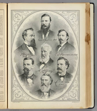
Full Title
Geo. H. Jackson, M.D., Thos. Ross, M.D.C.M., E.L. Parramore, M.D., A. Strong, M.D., Thornton Craig, M.D.C.M., L.B. Holmes, D.D.S., W.J. Prather. (Drawn by) E. Wyttenbach. De Pue & Co. Pub., S.F. Britton & Rey, Lith., S.F. (1879)
Publisher
De Pue & Company
Author
Trask, John B.
Full Title
Map Of The State Of California. Published by Britton & Rey Lithographers, Cor. of Commercial & Montgomery Sts. San Francisco. Drawn & Compiled from the most recent Surveys by J.B. Trask. Entered ... 1853 by Britton & Rey ... California.
Publisher
Britton & Rey
|