Browse All

1872 Map of the proposed line of Montgomery A … Separate Map Map of the proposed line of Montgomery A … |

1887 Britton & Rey's Guide Map of the City of … Pocket Map Britton & Rey's Guide Map of the City of … |

1887 Cover: San Francisco, Britton & Rey's gu … Pocket Map (Covers to) Britton & Rey's Guide Map of … |

1903 Golden Gate Park, 1903 Separate Map Map showing the Golden Gate Park, The Av … |

1852 Map of San Francisco. Separate Map Map of San Francisco, Compiled from late … |

1874 Map exhibiting the salt marsh ... lands … [Chart Map, Wall Map] Map exhibiting the salt marsh, tide and … |

1868 Covers: White Pine District Lander Co. N … Pocket Map (Covers to) Map Of White Pine District L … |

1868 White Pine District Lander Co. Nev. Pocket Map Map Of White Pine District Lander Co. Ne … |

1886 California. Separate Map Map of the state of California, compiled … |

1886 Cover: California. Separate Map (Covers to) Map of the state of Californ … |

1886 Text Page: California. Separate Map (Text Page to) Map of the state of Calif … |

1857 The County Of Alameda California. Wall Map Official Map Of The County Of Alameda Ca … |

1857 Britton & Rey's Map Of The State Of Cali … Wall Map Britton & Rey's Map Of The State Of Cali … |

1910 Covers: California And Nevada Pocket Map (Covers to) Weber's Township And County … |

1910 Title Page: Index to Map Of California A … Pocket Map (Title Page to) Weber's Township And Cou … |

1910 California And Nevada Pocket Map Weber's Township And County Map Of Calif … |

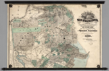
1868 Map Of The Outside Lands Of The City And … Separate Map Map Of The Outside Lands Of The City And … |

1868 Map Of The Outside Lands Of The City And … Separate Map Map Of The Outside Lands Of The City And … |

1888 Covers:Park Place, Formerly Known As Lau … Real Estate (Covers to) Second grand excursion to, a … |

1888 Park Place, Formerly Known As Laundry Fa … Real Estate Relative Position of Park Place, Laundry … |

1888 Park Place, Formerly Known As Laundry Fa … Real Estate Map showing A Portion Of Park Place, For … |

1899 System Of Sewerage For The City And Coun … Separate Map System Of Sewerage For The City And Coun … |

1869 Map Showing California Pacific Rail Road … Separate Map Map Showing California Pacific Rail Road … |

1914 California Highway And Railroad Map Separate Map Geographical, Topographical, State Highw … |

1895 Sutter Basin Separate Map Sutter Basin. Compiled from surveys made … |

1894 Map Of San Francisco Showing The Water S … Separate Map Map Of San Francisco Showing The Water S … |

1866 Map of Parts of California, Nevada, Oreg … Separate Map Map of Parts of California, Nevada, Oreg … |

1899 Oahu, Hawaiian Islands. Separate Map Oahu, Hawaiian Islands. Compiled from Ma … |

1891 California. County Atlas Map of the state of California, compiled … |
1869 City and County of San Francisco. Wall Map City and County of San Francisco. Compil … |

1908 San Francisco burnt area, 1906. Physical Atlas Map of the city of San Francisco showing … |

1872 Sale map no. 11. Salt marsh, tide lands, … Separate Map Sale map no. 11. Salt marsh and tide lan … |

1872 Sale map no. 11. Salt marsh, tide lands, … Separate Map Sale map no. 11. Salt marsh and tide lan … |

1873 San Francisco from latest surveys. Separate Map Map of San Francisco from the latest sur … |

1914 Madera County, Calif. Pocket Map Official map of Madera County, Californi … |

1914 Cover: Madera County, Calif. Pocket Map (Covers to) Official map of Madera Count … |

1888 Map of the City of Oakland and Surroundi … Wall Map Map of the City of Oakland and Surroundi … |

1868 San Francisco, surrounding country. [Separate Map, View] Birds eye view of the city of San Franci … |

1879 (Yolo Co. portraits) County Atlas Prof. A.M. Elston, Joseph Griffin, Mrs. … |

1879 Winters area residences, farms. County Atlas Residence and farm of Benjamin Ely embra … |

1879 (Yolo Co. portraits) County Atlas Jno. W. Rhodes, S.N. Mering, J.H. Harlan … |

1879 (Chiles family portraits) County Atlas P.S. Chiles, J.F. Chiles, Mrs. P.S. Chil … |

1879 Capay Valley, Harlan farm. County Atlas Farm of Jno. M. Rhodes, embracing 1,400 … |

1879 (Curtiss & Todd family portraits) County Atlas W.C. Curtiss, Mrs. G.G. Todd, mother of … |

1879 Pioneers Sacto. Valley. County Atlas Pioneers of the Sacramento Valley. John … |

1879 Pioneers Yolo County. County Atlas Pioneers of Yolo Co., Cal. Chas. F. Reed … |

1879 (Yolo Co. portraits) County Atlas J.W. Freeman, J.W. Aldrich, P.G. Everett … |

1879 (Yolo Co. portraits) County Atlas J.P. Bullock, A.W. Gable, H.C. Gable, J. … |
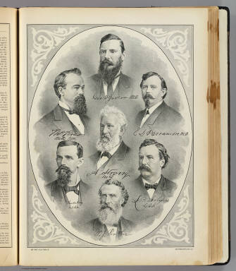
1879 (Yolo Co. doctors, dentists) County Atlas Geo. H. Jackson, M.D., Thos. Ross, M.D.C … |

1853 Map of the State of California. Separate Map Map Of The State Of California. Publishe … |