Browse All

1829 Cover: Atlas, State of New York. State Atlas (Covers to) An atlas of the State of New … |

1829 Half Title: Atlas, State of New York. State Atlas (Half Title Page to) An atlas of the Sta … |

1829 Title Page: Atlas, State of New York. State Atlas (Title Page to) An atlas of the State of … |

1829 Contents: Atlas, State of New York. State Atlas (Contents to) An atlas of the State of N … |

1832 New-York State, surrounding country. State Atlas Map of the State of New-York and the sur … |

1832 New York City & County. State Atlas Map of the City and County of New York w … |

1829 New York, Queens, Kings, Richmond counti … State Atlas Map of the counties of New York, Queens, … |

1829 Suffolk County. State Atlas Map of the County of Suffolk. By David H … |

1829 Westchester County. State Atlas Map of the County of Westchester. By Dav … |

1829 Dutchess, Putnam counties. State Atlas Map of the counties of Dutchess and Putn … |

1829 Orange, Rockland counties. State Atlas Map of the counties of Orange and Rockla … |

1829 Ulster County. State Atlas Map of the County of Ulster. By David H. … |

1829 Sullivan County. State Atlas Map of the County of Sullivan. By David … |

1829 Delaware County. State Atlas Map of the County of Delaware. By David … |

1829 Greene County. State Atlas Map of the County of Greene. By David H. … |

1829 Columbia County. State Atlas Map of the County of Columbia. By David … |

1829 Rensselaer County. State Atlas Map of the County of Rensselaer. By Davi … |

1829 Albany, Schenectady counties. State Atlas Map of the counties of Albany and Schene … |

1829 Schoharie County. State Atlas Map of the County of Schoharie. By David … |

1829 Montgomery County. State Atlas Map of the County of Montgomery. By Davi … |

1829 Hamilton County. State Atlas Map of the County of Hamilton. By David … |

1829 Saratoga County. State Atlas Map of the County of Saratoga. By David … |

1829 Washington County. State Atlas Map of the County of Washington. By Davi … |

1829 Warren County. State Atlas Map of the County of Warren. By David H. … |

1829 Essex County. State Atlas Map of the County of Essex. By David H. … |

1829 Clinton County. State Atlas Map of the County of Clinton. By David H … |

1829 Franklin County. State Atlas Map of the County of Franklin. By David … |

1829 St. Lawrence County. State Atlas Map of the County of St. Lawrence. By Da … |

1829 Jefferson County. State Atlas Map of the County of Jefferson. By David … |

1829 Lewis County. State Atlas Map of the County of Lewis. By David H. … |

1829 Herkimer County. State Atlas Map of the County of Herkimer. By David … |

1829 Oneida County. State Atlas Map of the County of Oneida. By David H. … |

1829 Madison County. State Atlas Map of the County of Madison. By David H … |

1829 Oswego County. State Atlas Map of the County of Oswego. By David H. … |

1829 Otsego County. State Atlas Map of the County of Otsego. By David H. … |

1829 Chenango County. State Atlas Map of the County of Chenango. By David … |

1829 Broome County. State Atlas Map of the County of Broome. By David H. … |

1829 Cortland County. State Atlas Map of the County of Cortland by David H … |

1829 Tompkins County. State Atlas Map of the County of Tompkins. By David … |

1829 Tioga County. State Atlas Map of the County of Tioga. By David H. … |

1829 Steuben County. State Atlas Map of the County of Steuben. By David H … |

1829 Onondaga County. State Atlas Map of the County of Onondaga. By David … |

1829 Cayuga County. State Atlas Map of the County of Cayuga. By David H. … |

1829 Seneca County. State Atlas Map of the County of Seneca. By David H. … |

1829 Ontario, Yates counties. State Atlas Map of the counties of Ontario & Yates. … |

1829 Wayne County. State Atlas Map of the County of Wayne. By David H. … |

1829 Livingston County. State Atlas Map of the County of Livingston. By Davi … |

1829 Monroe County. State Atlas Map of the County of Monroe. By David H. … |

1829 Orleans County. State Atlas Map of the County of Orleans. By David H … |
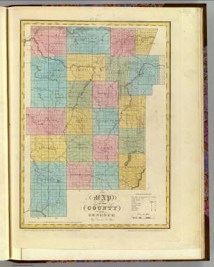
1829 Genesee County. State Atlas Map of the County of Genesee. By David H … |