Who What Where WhenREMOVEWHATWHEREWHO |
REFINE
Browse All : Case Map by Edward Stanford of United States
1-8 of 8
Author
Stanford, Edward
Full Title
Stanford's New Large-Print Map Of The United States Of North America. Distinguishing The Cities & Towns According To Population &c. And Shewing The Boundary Of The Seceded States. London: Edward Stanford, 6, Charing Cross, May 13th 1861. Constructed & Engrd. at Stanford's Geographical Establishmt. London.
Publisher
Edward Stanford
Author
Stanford, Edward
Full Title
Stanford's Map Of The United States And Part Of The Dominion Of Canada. London: Published by Edward Stanford, 55 Charing Cross, September 1st 1875. (inset) Newfoundland, Nova Scotia, Cape Breton & Prince Edward Is.
Publisher
Edward Stanford
Author
Stanford, Edward
Full Title
Stanford's Railway & County Map Of The United States And Territories. London. Edward Stanford, 6, Charing Cross. 1861.
Publisher
Edward Stanford
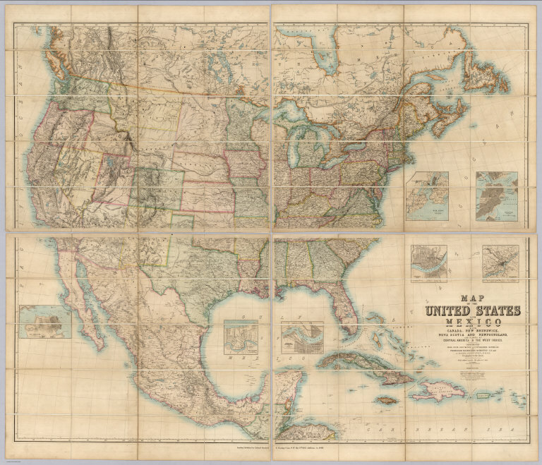
Author
[Johnston, Alexander Keith, 1804-1871, Rogers, Henry Darwin, Stanford, Edward]
Full Title
(Covers to) Map Of The United States And Mexico With Canada, New Brunswick, Nova Scotia and Newfoundland, And Parts Of Central America & The West Indies. Constructed From State Documents & Unpublished Materials By Professor H.D. Rogers of Boston U.S. and A. Keith Johnston, F.R.S.E Geographer to the Queen. London; Published by Edward Stanford, 6 Charing Cross, S.W. May 13th. 1861. Additions to 1869.
Publisher
Edward Stanford
Author
Stanford, Edward
Full Title
(Covers to) Stanford's New Large-Print Map Of The United States Of North America. Distinguishing The Cities & Towns According To Population &c. And Shewing The Boundary Of The Seceded States. London: Edward Stanford, 6, Charing Cross, May 13th 1861. Constructed & Engrd. at Stanford's Geographical Establishmt. London.
Publisher
Edward Stanford
Author
Stanford, Edward
Full Title
(Covers to) Stanford's Map Of The United States And Part Of The Dominion Of Canada. London: Published by Edward Stanford, 55 Charing Cross, September 1st 1875. (inset) Newfoundland, Nova Scotia, Cape Breton & Prince Edward Is.
Publisher
Edward Stanford
Author
Stanford, Edward
Full Title
(Covers to) Stanford's Railway & County Map Of The United States And Territories. London. Edward Stanford, 6, Charing Cross. 1861.
Publisher
Edward Stanford
Author
[Johnston, Alexander Keith, 1804-1871, Rogers, Henry Darwin, Stanford, Edward]
Full Title
(Covers to) Map Of The United States And Mexico With Canada, New Brunswick, Nova Scotia and Newfoundland, And Parts Of Central America & The West Indies. Constructed From State Documents & Unpublished Materials By Professor H.D. Rogers of Boston U.S. and A. Keith Johnston, F.R.S.E Geographer to the Queen. London; Published by Edward Stanford, 6 Charing Cross, S.W. May 13th. 1861. Additions to 1869.
Publisher
Edward Stanford
1-8 of 8
|