Who What Where WhenREMOVE |
REFINE
Browse All : Images by Fremont, J.C.
1-14 of 14
Author
Fremont, J.C.
Full Title
(Title Page to) Report of The Exploring Expedition to The Rocky Mountains in the Year 1842, and to Oregon and North California in the Years 1843-'44.
Publisher
Blair and Rives
Author
Fremont, J.C.
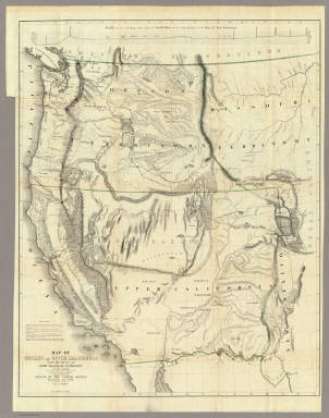
Full Title
Map Of An Exploring Expedition To The Rocky Mountains in the Year 1842, Oregon & North California In The Years 1843-44. By Brevet Capt. J. C. Fremont Of The Corps Of Topographical Engineers Under the orders of Col. J.J. Abert, Chief Of The Topographical Bureau. Lith. by E. Weber & Co. Baltimore, Md.
Publisher
Blair and Rives
Author
Fremont, J.C.
Full Title
(Title Page to) Geographical Memoir upon Upper California In Illustration of His Map of Oregon and California, by John Charles Fremont: Addressed to the Senate of the United States. Washington: Wendell and Van Benthuysen, Printers. 1848. [Senate.] 30th Congress, 1st Session. Miscellaneous. No. 148.
Publisher
Wendell and Van Benthuysen
Author
Fremont, J.C.
Full Title
Map Of Oregon And Upper California From the Surveys of John Charles Fremont And other Authorities. Drawn By Charles Preuss Under the Order of the Senate Of The United States, Washington City 1848. Lithy. by E. Weber & Co. Balto. (inset) Profile of the travelling route from the South Pass of the Rocky Mountains to the Bay of San Francisco.
Publisher
Wendell and Van Benthuysen
Author
Fremont, J.C.
Full Title
Las Mariposas Estate Mariposas County California. Containing 44,386 83/100 Acres Or 70 Square Miles. Lith of Sarony, Major & Knapp, 449 Broadway, N.Y. Max Strobel Engineer.
Publisher
Sarony, Major & Knapp
Author
[Fremont, J.C., Preuss, Charles]
Full Title
Topographical Map Of The Road From Missouri To Oregon, Commencing At The Mouth Of The Kansas In The Missouri River And Ending At The Mouth Of The Wallah Wallah In The Columbia. In VII Sections. Section VII. From the field notes and journal of Capt. J.C. Fremont, and from sketches and notes made on the ground by his assistant Charles Preuss. Compiled by Charles Preuss, 1846 By order of the Senate of the United States ... Lithogr. by E. Weber & Co. Baltimore ...
Publisher
U.S.
Author
[Fremont, J.C., Preuss, Charles]
Full Title
Topographical Map Of The Road From Missouri To Oregon, Commencing At The Mouth Of The Kansas In The Missouri River And Ending At The Mouth Of The Wallah Wallah In The Columbia. In VII Sections. Section I. From the field notes and journal of Capt. J.C. Fremont, and from sketches and notes made on the ground by his assistant Charles Preuss. Compiled by Charles Preuss, 1846 By order of the Senate of the United States ... Lithogr. by E. Weber & Co. Baltimore ...
Publisher
U.S.
Author
[Fremont, J.C., Preuss, Charles]
Full Title
Topographical Map Of The Road From Missouri To Oregon, Commencing At The Mouth Of The Kansas In The Missouri River And Ending At The Mouth Of The Wallah Wallah In The Columbia. In VII Sections. Section II. From the field notes and journal of Capt. J.C. Fremont, and from sketches and notes made on the ground by his assistant Charles Preuss. Compiled by Charles Preuss, 1846 By order of the Senate of the United States ... Lithogr. by E. Weber & Co. Baltimore ...
Publisher
U.S.
Author
[Fremont, J.C., Preuss, Charles]
Full Title
Topographical Map Of The Road From Missouri To Oregon, Commencing At The Mouth Of The Kansas In The Missouri River And Ending At The Mouth Of The Wallah Wallah In The Columbia. In VII Sections. Section III. From the field notes and journal of Capt. J.C. Fremont, and from sketches and notes made on the ground by his assistant Charles Preuss. Compiled by Charles Preuss, 1846 By order of the Senate of the United States ... Lithogr. by E. Weber & Co. Baltimore ...
Publisher
U.S.
Author
[Fremont, J.C., Preuss, Charles]
Full Title
Topographical Map Of The Road From Missouri To Oregon, Commencing At The Mouth Of The Kansas In The Missouri River And Ending At The Mouth Of The Wallah Wallah In The Columbia. In VII Sections. Section IV. From the field notes and journal of Capt. J.C. Fremont, and from sketches and notes made on the ground by his assistant Charles Preuss. Compiled by Charles Preuss, 1846 By order of the Senate of the United States ... Lithogr. by E. Weber & Co. Baltimore ...
Publisher
U.S.
Author
[Fremont, J.C., Preuss, Charles]
Full Title
Topographical Map Of The Road From Missouri To Oregon, Commencing At The Mouth Of The Kansas In The Missouri River And Ending At The Mouth Of The Wallah Wallah In The Columbia. In VII Sections. Section V. From the field notes and journal of Capt. J.C. Fremont, and from sketches and notes made on the ground by his assistant Charles Preuss. Compiled by Charles Preuss, 1846 By order of the Senate of the United States ... Lithogr. by E. Weber & Co. Baltimore ...
Publisher
U.S.
Author
[Fremont, J.C., Preuss, Charles]
Full Title
Topographical Map Of The Road From Missouri To Oregon, Commencing At The Mouth Of The Kansas In The Missouri River And Ending At The Mouth Of The Wallah Wallah In The Columbia. In VII Sections. Section VI. From the field notes and journal of Capt. J.C. Fremont, and from sketches and notes made on the ground by his assistant Charles Preuss. Compiled by Charles Preuss, 1846 By order of the Senate of the United States ... Lithogr. by E. Weber & Co. Baltimore ...
Publisher
U.S.
Author
Nicollet, J. N. (Joseph Nicolas), 1786-1843
Full Title
(Title Page to) Report Intended To Illustrate A Map Of The Hydrographical Basin of the Upper Mississippi River, Made by I.N. Nicollet ... February 16, 1841. Washington: Blair and Rives, Printers. 1843. [Senate.] 26th Congress, 2d Session. [237].
Publisher
Blair and Rives
Author
Nicollet, J. N. (Joseph Nicolas), 1786-1843
Full Title
Hydrographical Basin of the Upper Mississippi River From Astronomical and Barometrical Observations Surveys and Information by J.N. Nicollet ... assisted ... by Lieut. J.C. Fremont ... Reduced and compiled under the direction of Col. J.J. Abert in the Bureau of the Corps of Topl. Engrs. by Lieut. W.H. Emory ... 1843 ... W.J. Stone Sc.
Publisher
Blair and Rives
1-14 of 14
|