Who What Where WhenREMOVEWHEREShow More |
REFINE
Browse All : Images by Cramer and Henry Tanner and DeFerrer and Ellicott
1-8 of 8
Author
[Blunt, Edmund M. (Edmund March), 1770-1862, Hooker, William]
Full Title
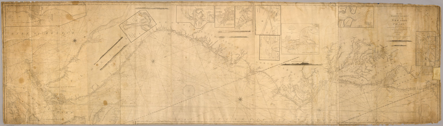
To the Marine Society of the city of New York; this chart, extending from lat. 40¦15' N. long: 72¦15' W. to Lat. 22¦35" N. long: 80¦25' W. is respectfully dedicated, by their obedient servant, Edmund M. Blunt, 1820 ... Plans engraved by Hooker, N. York.
Publisher
Wm. Hooker.
Author
[Blunt, Edmund M. (Edmund March), 1770-1862, Hooker, William]
Full Title
Books and charts published by Edmund Blunt or William Hooker, 202 Water, corner of Fulton Street, New-York, November, 1819.
Publisher
Wm. Hooker.
Author
Blunt, Edmund M. (Edmund March), 1770-1862
Full Title
Chart Of The North Atlantic Ocean, From the Equator to 65° North Latitude. According to the Latest Surveys & Observations. New York, Published by E. & G.W. Blunt, 154 Water St. Corner of Maiden Lane. 1832. Entered ... 1832, by Edmund & George W. Blunt ... New York. Additions to 1835. Engraved by W. Hooker. Lettered by D.R. Harrison. (with) three inset maps listed in Notes.
Publisher
E. & G.W. Blunt.
Author
[Adams, D. P., Blunt, Edmund M. (Edmund March), 1770-1862]
Full Title
The harbour of New York surveyed by Edmund Blunt. (with) Entrance fo the Chesapeake Bay, reduced from the surveys made by D.P. Adams and others by order of the Navy Commissioners of the U.S. by E. Blunt. (with) Views of land between Cape Henlopen and Cape Charles. (insets on 1st sheet of : The coast of the United States of North America; from New York to St. Augustine drawn and regulated according the the latest surveys and astronomical observations by Edmund Blunt). New York: published and sold by E. & G.W. Blunt, 154 Water Street cor. of Maiden Lane. Engraved & printed by W. Hooker, 202 Water Street, New York, 1827.
Publisher
E. & G.W. Blunt.
Author
Blunt, Edmund M. (Edmund March), 1770-1862
Full Title
The coast of the United States of North America; from New York to St. Augustine (2nd sheet) drawn and regulated according the the latest surveys and astronomical observations by Edmund Blunt. New York: published by E. & G.W. Blunt, 154 Water Street, corner of Maiden Lane. Engraved & printed by W. Hooker, 202 Water Street, New York. Entered acording to Act of Congress the 3rd. day of April 1827 by E. & G.W. Blunt of the State of New York.
Publisher
E. & G.W. Blunt.
Author
Blunt, Edmund M. (Edmund March), 1770-1862
Full Title
(The coast of the United States of North America; from New York to St. Augustine. 3rd sheet. Drawn and regulated according the the latest surveys and astronomical observations by Edmund Blunt). New York: published by E. & G.W. Blunt, 154 Water Street, corner of Maiden Lane. Engraved & printed by W. Hooker, 202 Water Street, New York.
Publisher
E. & G.W. Blunt.
Author
Blunt, Edmund M. (Edmund March), 1770-1862
Full Title
(The coast of the United States of North America; from New York to St. Augustine. 4th sheet. Drawn and regulated according the the latest surveys and astronomical observations by Edmund Blunt). New York: published by E. & G.W. Blunt, 154 Water Street, corner of Maiden Lane. Engraved & printed by W. Hooker, 202 Water Street, New York.
Publisher
E. & G.W. Blunt.
Author
[Blunt, Edmund M. (Edmund March), 1770-1862, Gauld, George.]
Full Title
The coasts of West Florida, Alabama, Mississippi & Louisiana; drawn from the surveys of Gauld, and improved from other authorities. By Edmund Blunt. New-York, published by E. & G.W. Blunt. No. 154 Water Street, corner of Maiden Lane, 1828. Engraved & printed at W. Hooker's office, New York.
Publisher
E. & G.W. Blunt.
1-8 of 8
|