Browse All

1829 Cover: Hooker's new pocket plan, City of … Pocket Map (Covers to) Hooker's New Pocket Plan Of … |

1829 Hooker's New Pocket Plan Of The City Of … Pocket Map Hooker's New Pocket Plan Of The City Of … |

1833 Cover: Hooker's new pocket plan, City of … Pocket Map (Covers to) Hooker's New Pocket Plan Of … |

1833 Hooker's New Pocket Plan Of The City Of … Pocket Map Hooker's New Pocket Plan Of The City Of … |

1820 Chart, extending from 40¦15' N. , 72¦15' … Chart Map To the Marine Society of the city of New … |

1820 Books, charts by E. Blunt or W. Hooker. Chart Map Books and charts published by Edmund Blu … |

1827 The harbour of New York, Entrance to Che … Chart Atlas The harbour of New York surveyed by Edmu … |

1827 The coast of the United States from New … Chart Atlas The coast of the United States of North … |

1827 The coast of the United States from New … Chart Atlas (The coast of the United States of North … |

1827 The coast of the United States from New … Chart Atlas (The coast of the United States of North … |

1827 Composite: U.S. coast N.Y. to St. August … Chart Atlas (Composite of) The coast of the United S … |

1828 The coasts of West Florida, Alabama, Mis … Chart Atlas The coasts of West Florida, Alabama, Mis … |

1804 United Kingdoms. World Atlas United Kingdoms of Great Britain and Ire … |

1804 Scotland. World Atlas Scotland. From Genl. Roy's map corrected … |

1804 Netherlands. World Atlas Netherlands. From Ferrari's map. Hooker … |

1804 Austrian Dominions. World Atlas Austrian Dominions. From Arrowsmith's ma … |

1804 Turkey In Europe. World Atlas Turkey in Europe. From Arrowsmith's Map … |

1804 Germany north. World Atlas Germany north of the Mayn. From Chanchar … |

1804 Central Asia. World Atlas Central Asia. From Du Halde, D'Anville, … |

1804 Hindoostan. World Atlas Hindoostan. From Arrowsmith's map of Asi … |

1804 East India Islands. World Atlas Chart of the East India Islands exhibiti … |

1804 North America. World Atlas North America. Hooker sc. (Published by … |

1804 Maine. World Atlas Maine. Drawn by S. Lewis. Engd. by Hooke … |

1804 British possessions in America. World Atlas British possessions in America. Jones sc … |

1804 South America. World Atlas South America. Hooker sculpt. (Published … |

1804 Egypt. World Atlas Egypt. From D'Anville. Ruld. by Hooker. … |

1812 United Kingdoms. World Atlas United Kingdoms of Great Britain and Ire … |

1812 Netherlands. World Atlas Netherlands. From Ferrari's map. Hooker … |

1812 Austrian Dominions. World Atlas Austrian Dominions. From Arrowsmith's ma … |

1812 Germany north. World Atlas Germany north of the Mayn. Engraved by T … |

1812 Hindoostan. World Atlas Hindoostan. From Arrowsmith's map of Asi … |

1812 British possessions in America. World Atlas British Possessions in America. Jones sc … |

1812 South America. World Atlas South America. Hooker sculpt. (Boston: P … |

1812 Egypt. World Atlas Egypt. From D'Anville. Ruld. by Hooker. … |
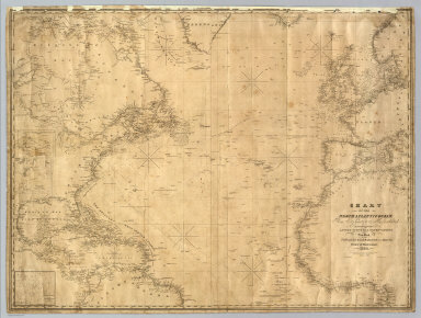
1835 North Atlantic Ocean. Chart Map Chart Of The North Atlantic Ocean, From … |